40 Surprising Maps That Show A Completely Different Side To The World We Live In (New Pics)
Who doesn't love a good map? I'd even say we'd get lost without one. They enrich our understanding of the world in a simple, visual way.
Maps teach us not only about the size and shapes of countries but also show many more interesting things, like earthquake locations and wealth distribution. The local status of gay marriage or car reliance. Pretty much everything we have data on!
So let's revisit this subreddit for a new dose of cartography — it hits just as strong as the previous ones.
This post may include affiliate links.
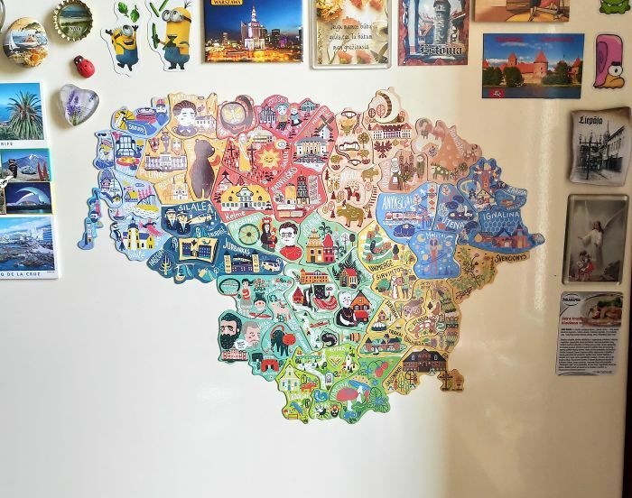
Lithuania Has Made A Map Of Magnets In Which Each Magnet Can Only Be Found In A Specific Area, To Boost Tourism, Specifically Local Tourism. (Credit To Demilked)
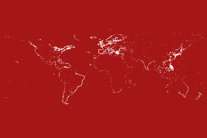
Outline Of The World By Mapping All Lighthouses (Osm Data, Oc)
The creator of this online group, Patrick McGranaghan, described himself in a previous Bored Panda article on the subreddit as a "Denver-based techno-geek with a focus on all things geospatial and cartographic and a coding hobbyist with an emphasis on geospatial applications."
He is a land surveyor and a member of #maptime Denver, Rocky Mountain Map Society, NACIS, PLSC, Charles Close Society, and Open Street Map Foundation, just to name a few. He decided to share his passion with the world and start the project in May 2011 while living in Taiwan, and the rest is history.
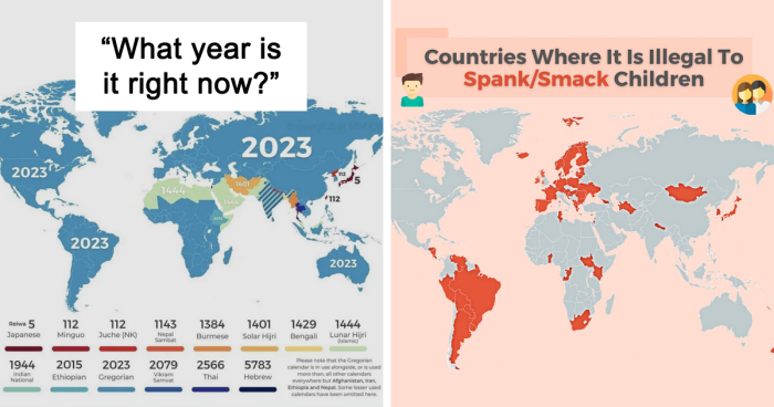
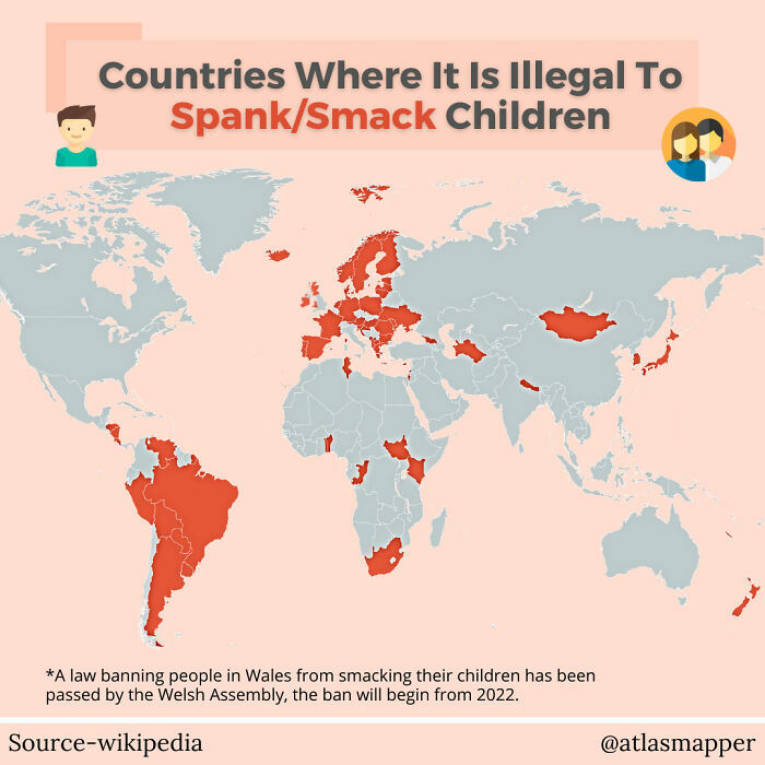
Countries Where It Is Illegal To Spank/Smack Children (700x700)
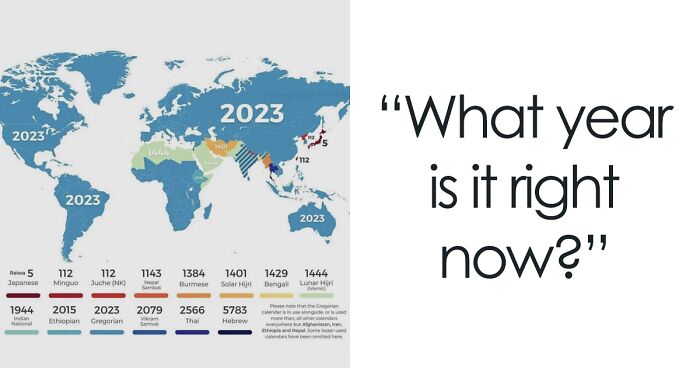
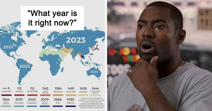
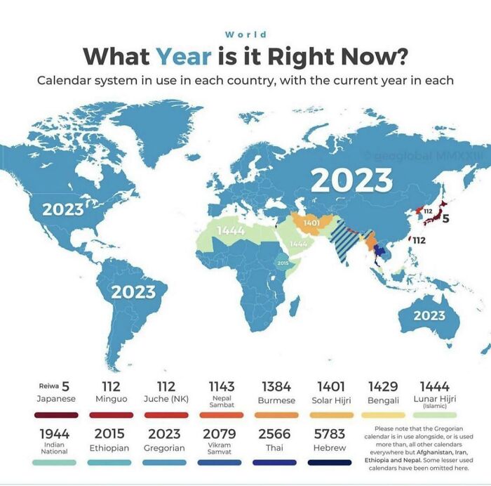
What Year Is It Right Now?
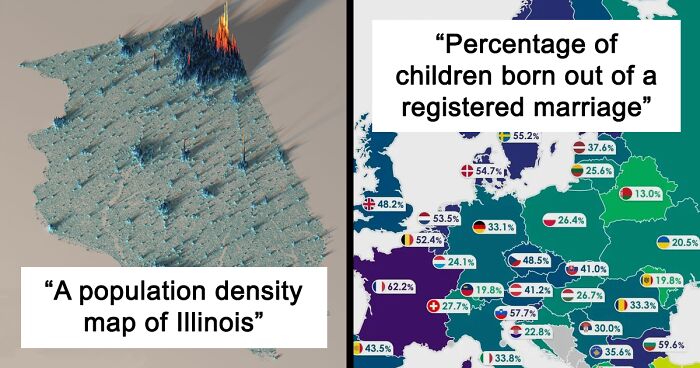
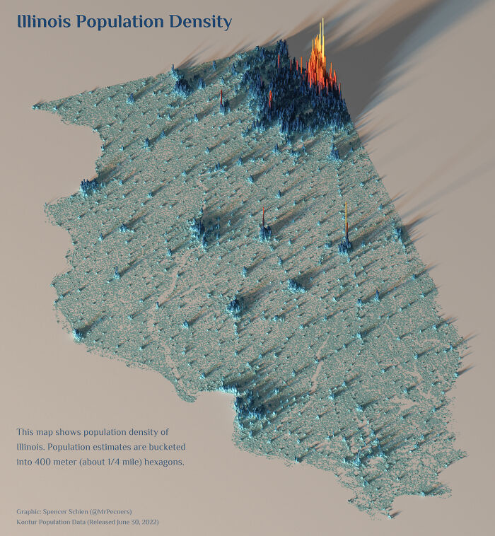
A Population Density Map Of Illinois
Patrick revealed that while the community was pretty stable in the past, everything changed the morning when Russia invaded Ukraine.
"The subreddit usually has between 2,000 and 4,000 users at a given moment on a normal day. That number spiked to a peak of over 20,000 users looking for ... maps of the situation there," he told us.
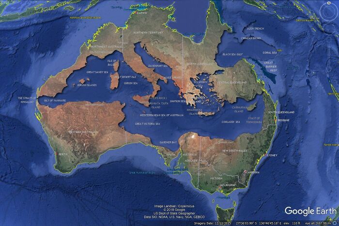
Mediterranean Sea Fits Inside Australia - Should Be A Much Better Image Than Last One
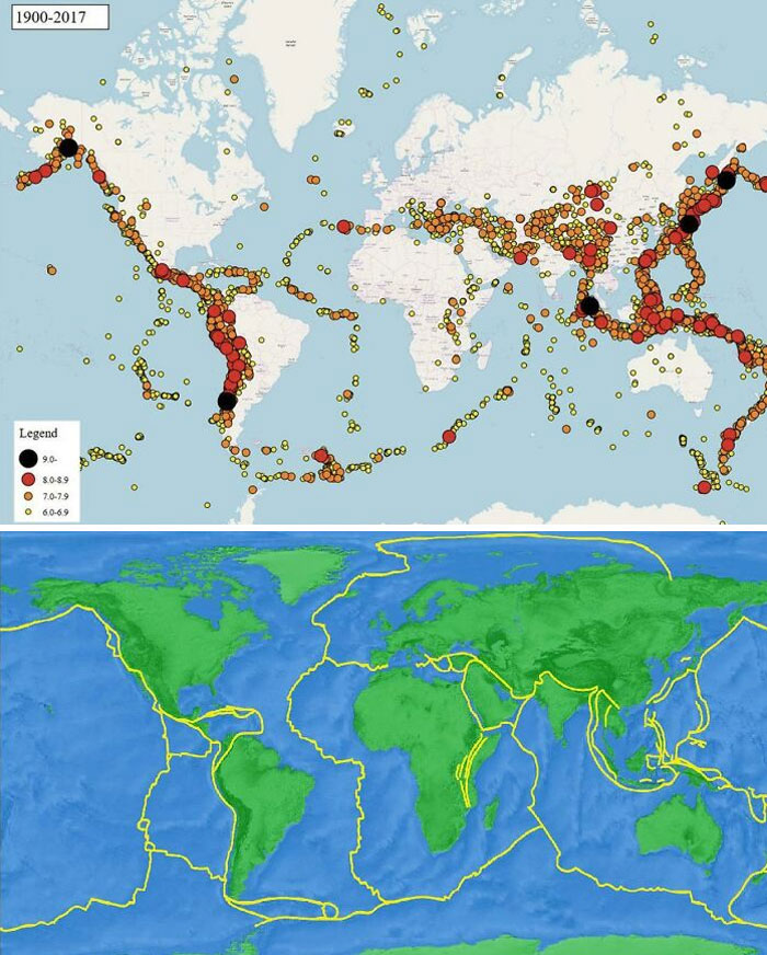
Someone Here Posted A Map Of Earthquakes Since 1900(Top One) Now Watch It 1by1 To The Map Of Actual Tectonic Plates(Bottom One)
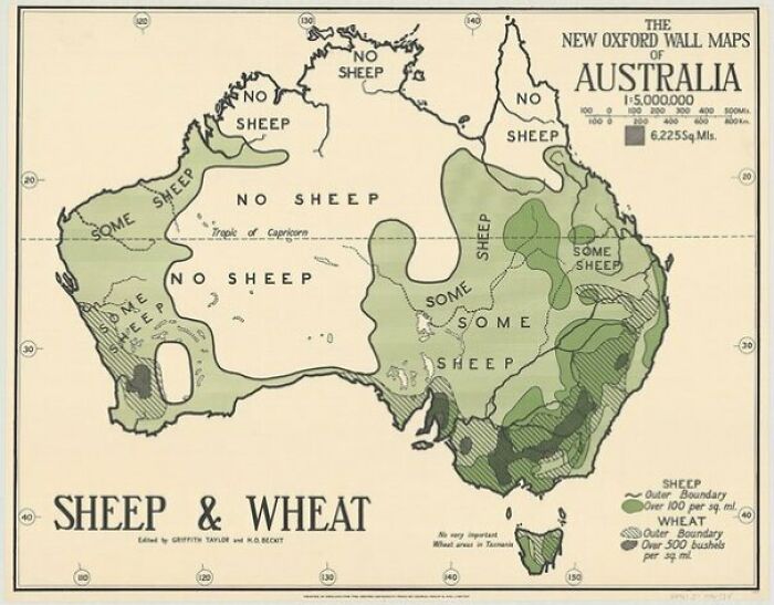
1920 Australian Map Of Sheep
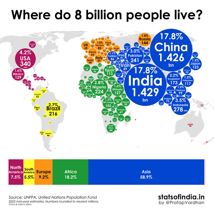
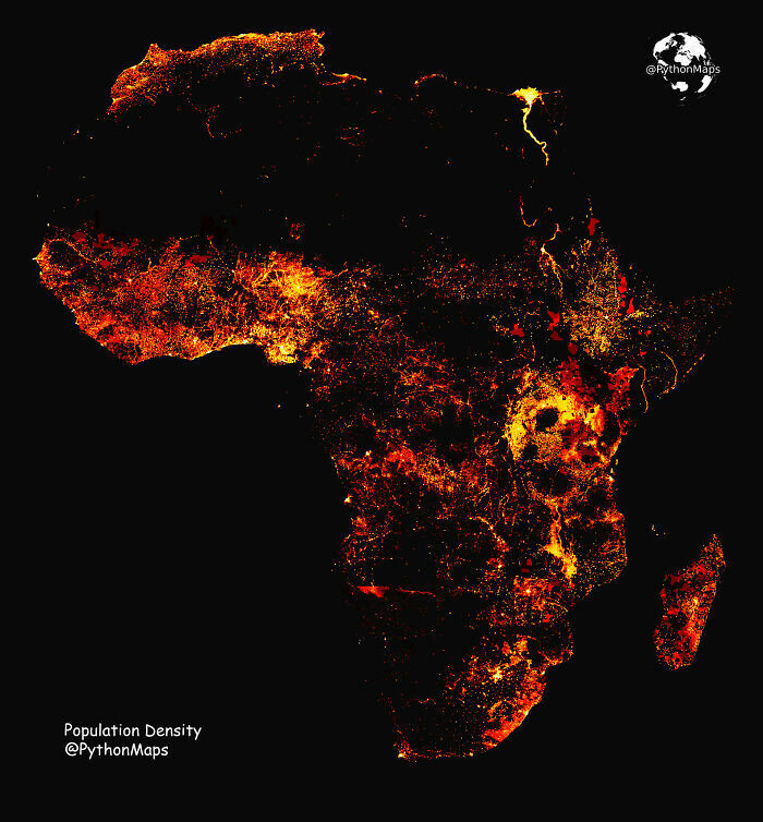
Where Does The World's Population Of 8 Billion Live?
When it comes to the way people think about cartography, the founder of the subreddit believes it's currently going through a period of change.
"The previous generation was accustomed to paper maps that they used to navigate. This required skills in orientation and awareness that are no longer necessary with digital maps on mobile devices. Whilst there are lots of articles that eulogize the loss of these skills, I don't think it's necessarily all bad," he explained.
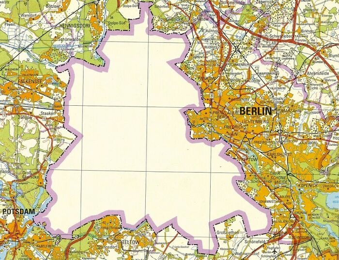
Here Is A 1988 Map Of Berlin (Produced In The Ddr)
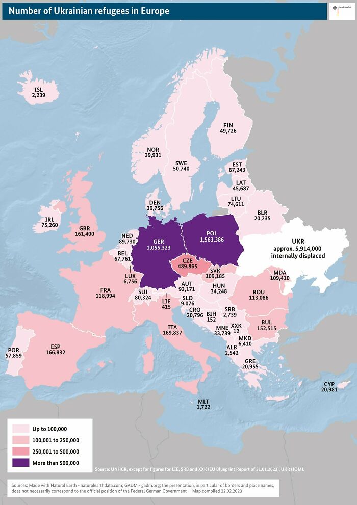
Number Of Ukrainian Refugees Displaced In Europe In February 2023
I wish they would flood any and every public ... thing the putin-friends of our furthest right of the relevant parties, the AfD, are conducting, and teach them some common sense. Ok, they're rightwingers leaning well into radical (not all members are radical, but you can't remain a member without at least finding the publicly known radicalism to be acceptable), so we cannot expect them to be of the brightest kind... But I don't see how it requires much thought or thinkability to understand that invading other countries, unprovoked and against every contract, promise and rights, is wrong by any and every means.
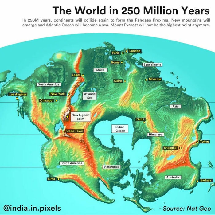
The World In 250 Million Years
Uh, according to my science class, the mid-atlantic ridge sits on a divergent plate boundary and the Pacific plate is surrounded by covergent plates... but that info might be inaccurate ¯\_(ツ)_/¯
You are correct, this map os wrong. The Atlantic is growing and Pacific shrinking.
Load More Replies...As people have pointed out, this map is wrong. The Pacific is shrinking and the Atlantic is growing. The resulting continent is to be named Amasia.
Amasia is an amazingly good name for that though…
Load More Replies...Wow border control will certainly change. Don't tell the folks who want a southern wall...
Humans will have all died out by then, as well as a lot of plant and animal life if we continue this way.
Well it's sad a lot of species will die with us, but after, new ones will be evolving in peace. And maybe the next human-like (in terms if capabilities) species will have more respect for nature's wonders.
Load More Replies...Ummm, no. I believe I've read that the west coast of North and South America are very slowly moving toward the east coast of China and other Asian companies. One of the reasons there are a lot of earthquakes along those coastlines.
Florida will go from sea level to space level :) Beach view to mountain view woohoo!
I don’t think this is right, they would move more far apart from each other than closer
Yeah its opposite. Maybe they meant 500 million years ago as Pangea?
Load More Replies...I will witness the triumphant return of the Appalachian Range. Former and new Highest Mountain champion of the world.
Question: Does this take into consideration water levels or just an example of where places will end up due to tetonics?
I was just about to complain that the flights from Seattle to Paris are already hideously long (10hrs), but it appears that both cities will be closer to the polar cap, so this should really shorten the distance. So exciting!, I can't wait.
Given the age of Appalachian mountains, I can't picture how the Himalayan Mountains or the Andes would largely disappear so quickly. Much more believable but still wild: Los Angeles is up by ALaska. It took me a while to figure out what happened in the Atlantic: Africa has moved between North America and Europe, rotating Europe clockwise about 45 degrees. The new Top of the World is Florida.
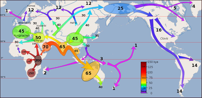
Estimated Migration Of Early Homo Sapiens Out Of Africa To The Rest Of The World, In Thousands Of Years Ago (Kya)
"The digital generation has a heightened awareness of how maps can visualize data," Patrick pointed out.
"The tools to make maps have been democratized. This has increased interest in finding new and clever ways to see spatial data."
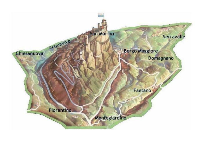
Relief Map Of San Marino
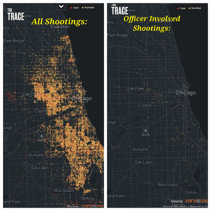
All Shootings vs. Shootings With Officer Involved In Chicago (2014-2022)
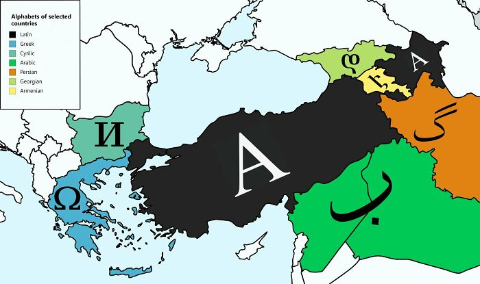
Turkey, Bordering 7 Different Countries With 7 Different Alphabets
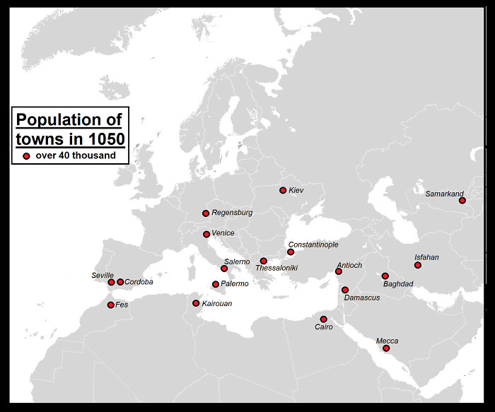
The Largest Towns In 1050 In Europe, North Africa And West Asia (Population Over 40 Thousand)
In another Bored Panda interview, Patrick said that moderating the subreddit has always been about finding the right balance.
"It is impossible to please everybody. If you are too laissez-faire you get a lot of low-effort and ugly submissions and the users complain. If you are too strict, then you risk alienating those who supply the content for the sub. I try to find a balance between these two extremes. Overall, I'm satisfied with the moderating and I don't foresee any changes in the immediate future," he said.
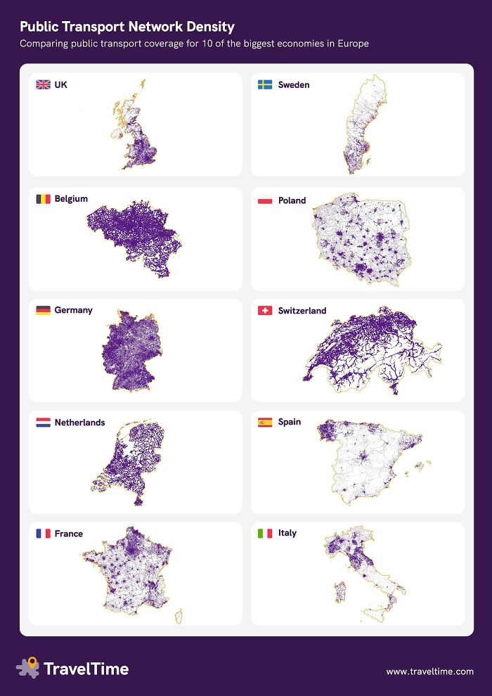
Public Transport Network Density
In case of Germany it's not a question of density but if there is any traffic on it... (hint: You need a car in this country to get around outside of cities)
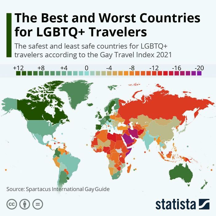
The Best And The Worst For Lgbtq+ Travelers
Go Canada! I hope that soon being LGBT+ becomes normalised everywhere
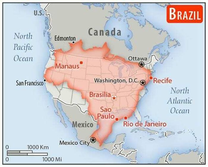
How Big Brazil Actually Is!
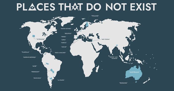
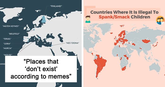
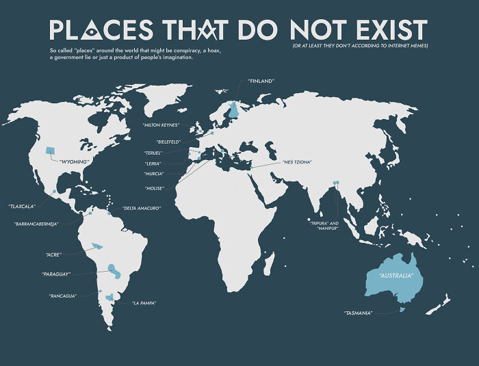
Places That "Don't Exist" According To Internet Memes (Many Based On The Original "Bielefeld Conspiracy")
The popularity of this subreddit and, in turn, alternative maps, illustrates the way Chris Heffernan, a teacher of 20 years, approaches geography. Heffernan, who is a seventh-grade social science and math teacher at Jefferson Junior High School in Naperville, Illinois, said he no longer thinks about map quizzes when he thinks about geography class, but rather “human geography,” the study of culture, economy, and politics, which ends up affecting all of us.
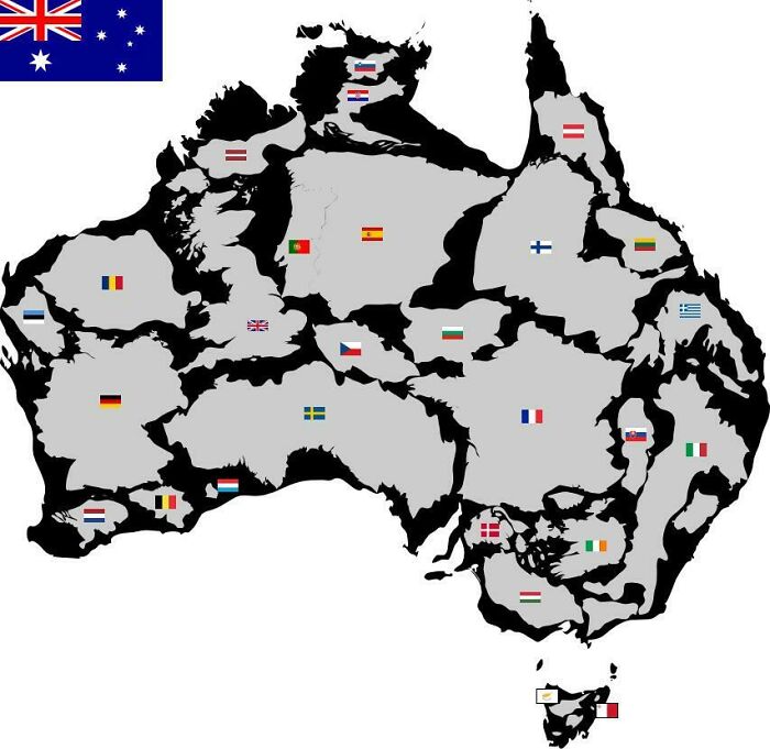
The Size Of Australia vs. Other Countries
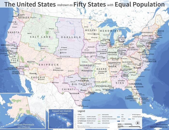
The U.S. Map Redrawn As 50 States With Equal Population
I like how California has now become 5 separate “states” XD It took me a while to realize this map has chunked out “areas” that match each other area’s population, which is why Cali is 5 tiny “states”… LOTS of population packed into relatively small areas in the state.
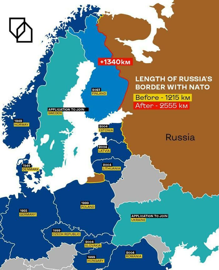
Russia’s New Border With Nato Now That Finland Is Finally In Nato!
They had it coming. All the silly accusations of "NaTo Is ThReAtEnInG tHe PoOr DeAr VlAdi11" become more and more real, the more they react to them as if they already had been real. Well ... the three baltic states, former soviet republics, now see that their decision to join NATO was the rightest idea they ever could even have had - what else is it that makes Ukraine different to them?
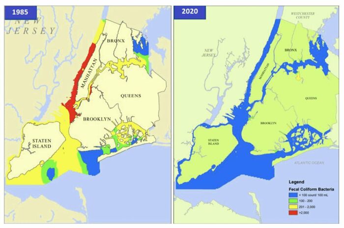
Fecal Bacteria Contamination In New York Waters, 1985 vs. 2020
"Geography matters more now than ever because students need to know human geography," Heffernan wrote. "They need to understand the relationships that exist between cultures. They need to see not just the differences in cultures, but the similarities."
"Students need to know that the kid sitting in a school in Afghanistan today probably doesn’t speak the same language, practice the same religion or live in a home that looks anything like a student in the United States, but they have a lot of things in common [too]."
"Geography matters now more than ever because of global crises that range from migration to climate change to pandemics," Heffernan continued. "Geography matters because we are all connected. Geography matters because this is our world."
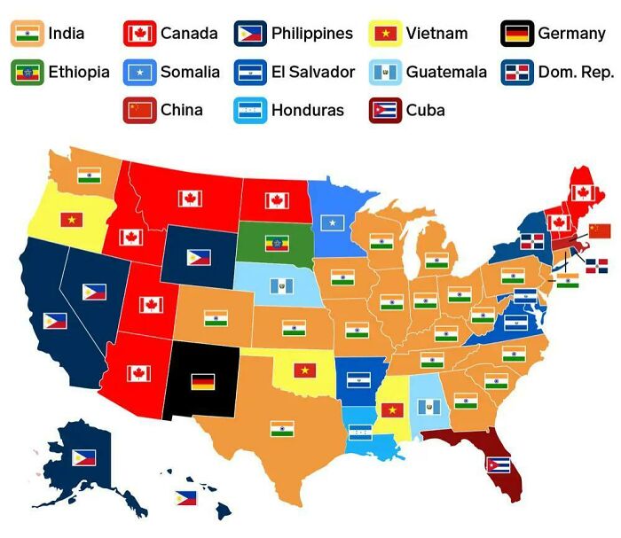
Most Common Country Of Birth For Residents Of Foreign Origin, Excluding Mexico
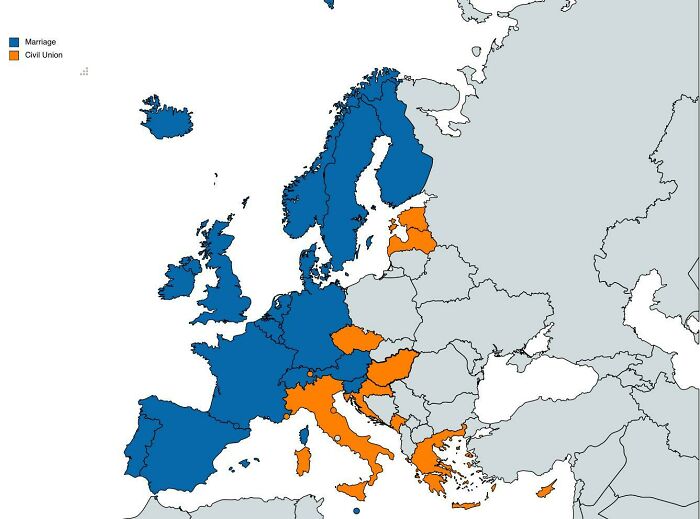
Status Of Gay Marriage In Europe
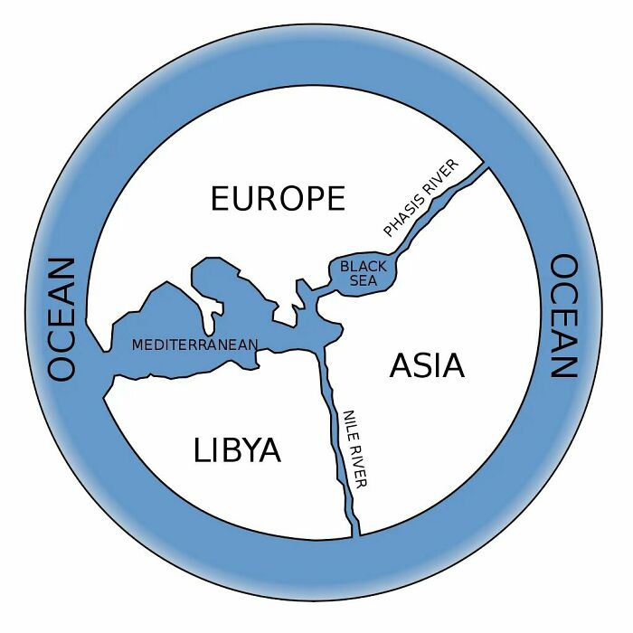
The First World Map By Anaximander Of Miletus (610bc-546bc), Greece Mathematician And Geographist. Original Map Was Not Saved!
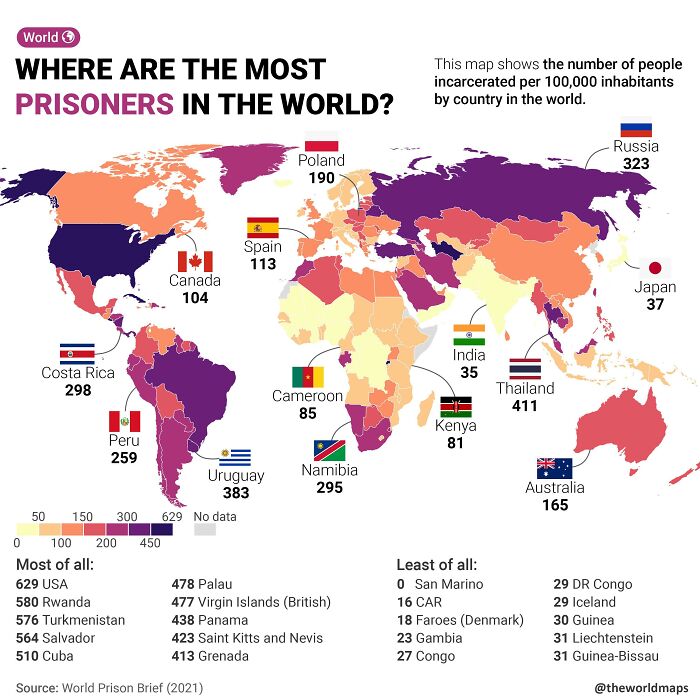
Number Of Prisoners Per 100,000 People Across The World
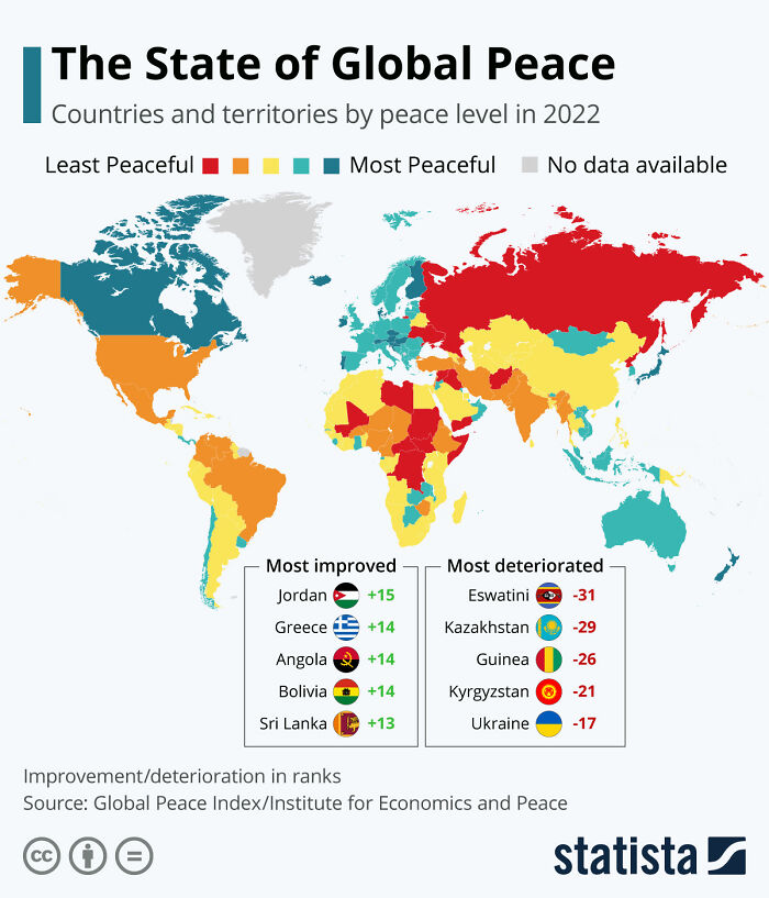
The 2022 Edition Of The Global Peace Index
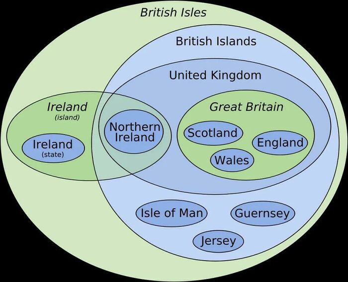
The Euler Diagram-Map Of The British Isles./-
The only quibble I have with this is 'British Isles'. Eire/the Republic of Ireland most definitely does not agree to this term being used of their country. Eire is not part of the British Isles as Eire is not part of Britain. formally disavowed in September 2005 by the Irish Government when Foreign Minister Dermot Ahern stated: "The British Isles is not an officially recognised term in any legal or inter-governmental sense. It is without any official status.
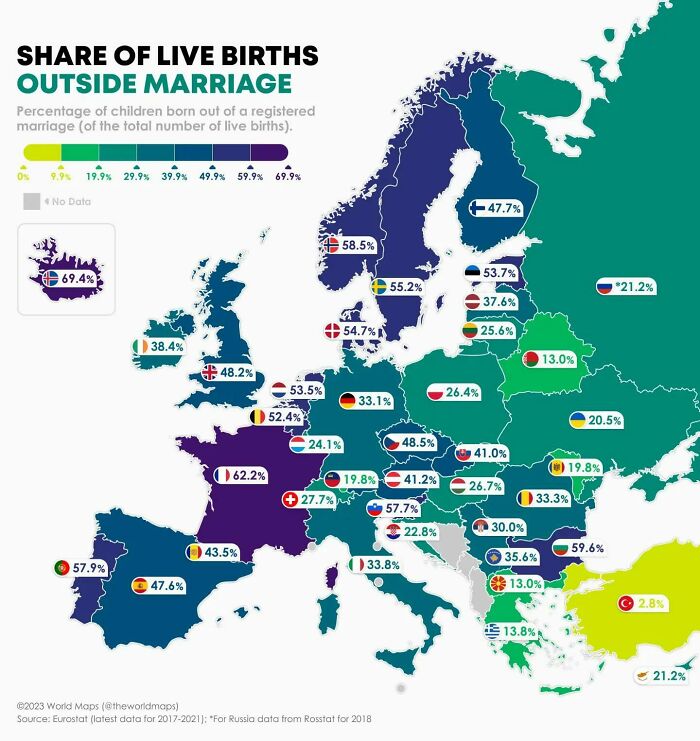
Percentage Of Children Born Out Of A Registered Marriage
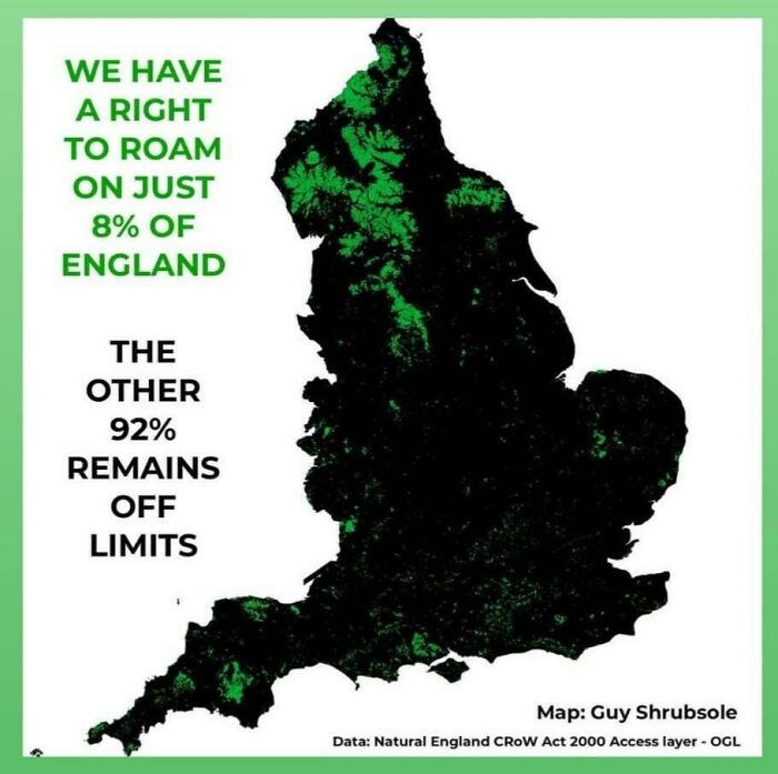
England, Right To Roam Map
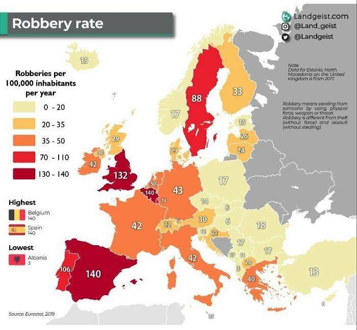
Robbery Rates In European Countries
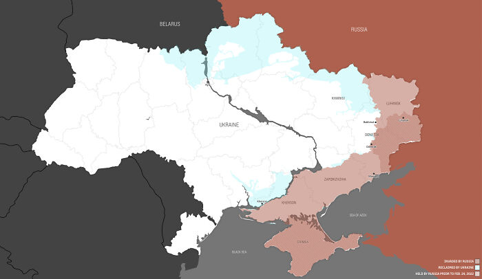
How Much Territory Russia And Ukraine Hold At One Year Of War
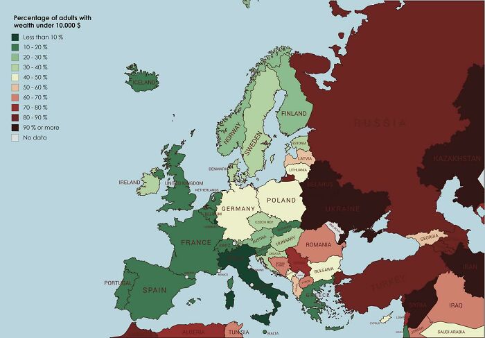
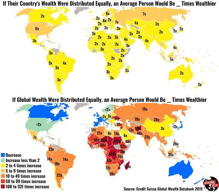
Percentage Of Europeans Whose Wealth Is Under $10,000
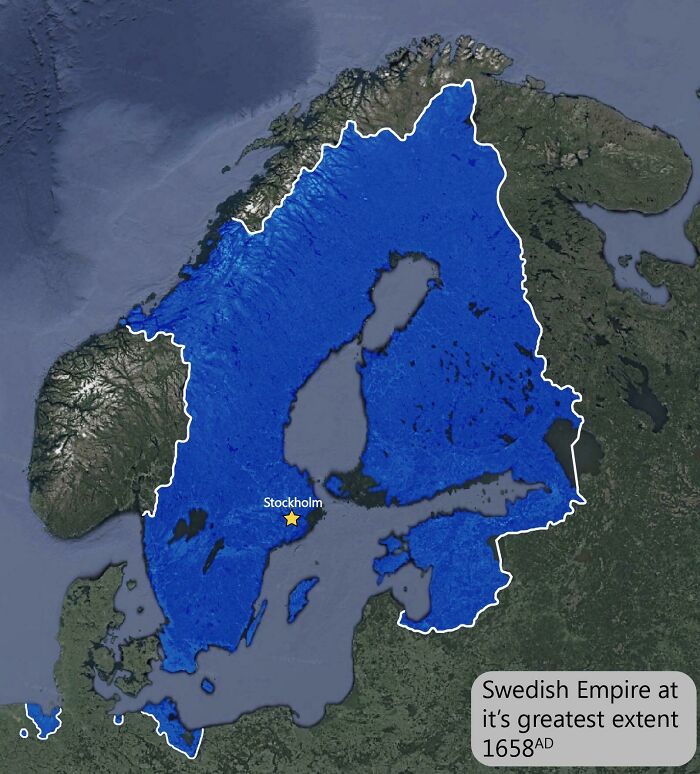
The Swedish Empire At It’s Height
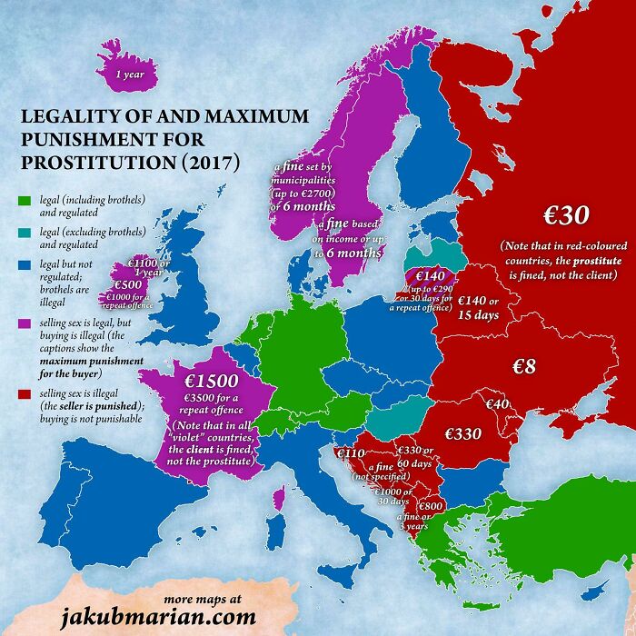
Legality Of Prostitution
Violet is the only humane option. Illegal for the buyers. Sex work is almost always a form of abuse, not of empowerment and since it's near impossible to find out which sex worker is coerced and which one does it on their own free will (for the authorities AND the buyers in equal measure!) punishing the buyers is the only way. Also when someone is paying for sex they can't tell if the prostitute is being forced and thus they're ok with possibly committing rape.
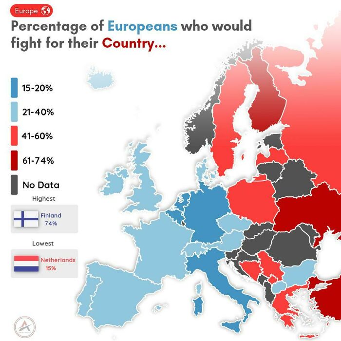
Europeans Who Would Fight For Their Own Country
I see this a tad ... different. I'd not hesitate defend every european border that surrounds an area of humanism against any attack of less humanist invaders. I'd link it to ideas and values more than to country, because that's what really counts. But, if I'd be able to supply a service that's of value there, why not? If I were a Russian, given that I know and feel what I do now as a german, I would certainly NOT fight "for my country", but either get my a*s into safety, or get my a*s into Ukraine's service.
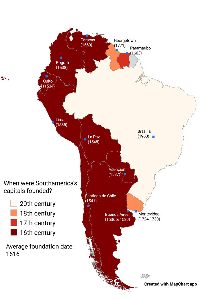
When Were Southamerica's Capitals Founded?
Hmm I liked most of these but they can be misleading. The thing is to view them with a critical eye but go easy on the author of the post because they are usually just blindly copypasting from Reddit and don't bother checking the details.
OK pandas, there's a lot of really interesting maps but they're all toward the bottom. Can we vote them up higher please so more people can enjoy them when BP inevitably hides them behind a link at the bottom?
Caught myself downvoting (on former #14 about gangs, guns, and violence) but have removed all of those minuses. So many Pandas here find support and healing for surviving horrific prejudice, marginalization, and abuse it's weird to see them sling vitriol at others. By retaliating for the hate I got, I almost bought into their hating. But nope. Not going to be part of that.
My 8 year olds version of Europe... It won't let me post it. But man--- it is awesome. H started Africa this morning. It's all amazing. Borders countries even the tiny ones fille din with their flag. He has markers and white out, and erasers. He is doing his best to honor every country and every flag. At 8 years old
So you’re whining because an article taught you something, aroused your interest but you had to do something on your own?
Load More Replies...Hmm I liked most of these but they can be misleading. The thing is to view them with a critical eye but go easy on the author of the post because they are usually just blindly copypasting from Reddit and don't bother checking the details.
OK pandas, there's a lot of really interesting maps but they're all toward the bottom. Can we vote them up higher please so more people can enjoy them when BP inevitably hides them behind a link at the bottom?
Caught myself downvoting (on former #14 about gangs, guns, and violence) but have removed all of those minuses. So many Pandas here find support and healing for surviving horrific prejudice, marginalization, and abuse it's weird to see them sling vitriol at others. By retaliating for the hate I got, I almost bought into their hating. But nope. Not going to be part of that.
My 8 year olds version of Europe... It won't let me post it. But man--- it is awesome. H started Africa this morning. It's all amazing. Borders countries even the tiny ones fille din with their flag. He has markers and white out, and erasers. He is doing his best to honor every country and every flag. At 8 years old
So you’re whining because an article taught you something, aroused your interest but you had to do something on your own?
Load More Replies...
 Dark Mode

 No fees, cancel anytime


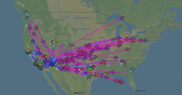











![Percentage Of Population Able To Hold A Conservation In German [607x650] Percentage Of Population Able To Hold A Conservation In German [607x650]](https://www.boredpanda.com/blog/wp-content/uploads/2023/05/6464b57e2c2ac_1d9qvmqsarca1__700.jpg)



![Italian And German Surnames In South America [oc] Italian And German Surnames In South America [oc]](https://www.boredpanda.com/blog/wp-content/uploads/2023/05/6464b72483e83_uq895sm47nxa1-png__700.jpg)
![The United States As James K. Polk Wanted It [964 X 740] The United States As James K. Polk Wanted It [964 X 740]](https://www.boredpanda.com/blog/wp-content/uploads/2023/05/6464b513517fc_pwXoy__700.jpg)
