Get Premium
Dark mode theme is available exclusively for premium users. Learn more about the benefits of subscribing.
No fees, cancel anytime.

 Dark Mode Ad-Free Browsing Unlimited Content
 Ad-Free Browsing Unlimited Content Dark Mode
Join 1.2 million Panda readers who get the best art, memes, and fun stories every week!
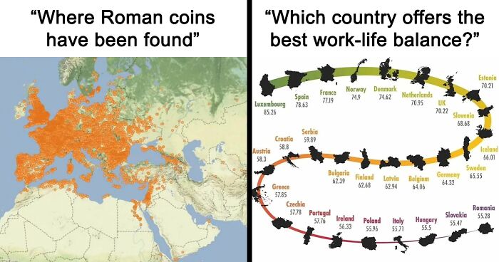
Cartography is cool. Where would we be without it as a species? I, personally, wouldn't know that my country looks like a tiny Africa and would get lost driving in any new city that I visit. We can also learn tons of cool stuff from maps, like in which countries it's illegal to dance on a bar.
If you like learning new random facts and are partial to geography, you'll probably love Fan Maps. It's an Instagram page that features cool, interesting maps that let you learn something new with each different one. Eager to get some knowledge? Scroll down and check them out!
To know more about mapmaking magic, we reached out to Daniel P. Huffman, a cartographer and a mapping educator. He told us more about what the day of a cartographer is like, what misconceptions people have about his job, and what's the secret to making interesting and creative maps.
Daniel Huffman: Something About Maps | Portfolio | Mastodon | Prints
This post may include affiliate links.
Search thetruesize website, you can move the countries and see their real size, so interesting.
The story of how Daniel got into mapmaking is a long one, and he has detailed it in his blog. But he agreed to tell us the short version, too. "I like maps and wanted to pursue a creative profession while struggling with depression," he told us via email.
For him, making maps is a form of art. "Mapmaking is a practical art: we have to fulfill specific goals and produce something functional, but it's also very much down to individual preferences of aesthetics and taste. It's like any artisan — a maker of furniture or pottery or a designer of buildings, etc."
Still, there is a fair amount of practicality in mapmaking. "Another common analogy I use is journalism," Daniel tells us. As an educator, he often used to have journalism students in his courses, so the two disciplines somewhat overlap.
"Journalists go out and gather as much information as they can, but they then curate what information is shown to the reader," the mapmaker says. "They decide what pieces are most critical and leave off the rest. And then they use their creative skills to find a way to present that information in an engaging way."
So, what do mapmakers actually do? Aside from the creativity aspect of the job, where do they get their information from? "My days are spent on the computer," Huffman tells us.
"Gathering data, processing it through specialized geographic information software tools to get the pieces that I want, and then using graphic design software to style things how I like — setting labels, choosing colors and line weights, etc. And there is a lot of email[s], of course. Going back-and-forth with my clients and such."
Thank god they likely served the drinks at the Super Bowl with paper straws. Plastic straws would be so bad for the environment ...
Apparently, mapmaking doesn't sound so cool to everybody. "When I tell people what I do for a living, I am often met with a response like: 'Hasn't everything been mapped already? Why are there still mapmakers?' These responses always surprise me. People seem very unaware of how often they interact with maps," Daniel points out.
This map is made before Thanksgiving. After that day, the map is all yellow.
And he's probably right: we use maps for almost everything, but they've been so ingrained into our everyday lives that we barely register how omnipresent they are. "In the Western world, most of those people have probably seen several maps just that day: on their phone, in the news, on a sign by the bus stop, etc.," Daniel says.
"We interact with maps constantly, but for some reason, people don't stop to think of them as 'maps' when I tell them that I am a mapmaker. There is a person (or group) behind every map you consume," he gives us some food for thought.
Does anyone really believe that those bottles have water sourced from where it claims?
"All maps are subjective, just like anything created by humans," Huffman says. "Someone made decisions about what should be shown and how. And everyone will do it differently." He goes back to the journalism analogy -- how different journalists can cover the same topic from a different angle. One might choose to omit a thing, and others would include it in their piece.
"There's nothing nefarious about that: you just make different decisions. It is the same for maps," Huffman tells us. "We all consider our audience and make assumptions about what that audience needs to know. On a tourist map, I might choose to show certain popular buildings but probably would not show something like crime statistics, even though both of those things are part of the reality of the place."
Population of South Korea is shrinking every year. England has the benefit of immigration.
"There's no set answer to how to be 'interesting and informative,' but it helps to always keep your audience in mind. What they want, what they expect, and how easily they can read what you are trying to communicate," the mapmaker and mapmaking educator says.
Huh, and growing up in Tennesse I would have always thought Mexico would have been closer
There doesn't seem to be that much difference between 250 and 500. Unless I am blinder than I thought, they look exactly the same
Here are some fun map facts for you: one of the oldest surviving maps is the Babylonian Map of The World. Archaeologists date it back to around 700 to 500 B.C. The map was a clay tablet nearly the size of an iPhone.
At the center of the map was a circular Babylon, divided by the Euphrates River and surrounded by the ocean. Historians say it wasn't so much about navigation but about imagining yourself at the center of the world.
France and Denmark, the only countries where you first have to master mathematics, before you can learn how to count to 100
A more accurate first attempt at a map was by Claudius Ptolemy. He located towns with the help of documents and by speaking with travelers. He put his findings on paper on a system of longitude and latitude and plotted around 10,000 locations. It included places in Britain, Europe, Asia, and North Africa.
So I live outside Denver about where the dot of the “I” in the word Relative. And my sister lives in Houston, TX, between Prague and Milan on this map. Driving away from her house, 12 hours o driving and I hadn’t left Texas yet.
Give me half an hour and an extra kilometer, and I'll take you to Asia and South America as well. Untitled-6...9975c9.jpg 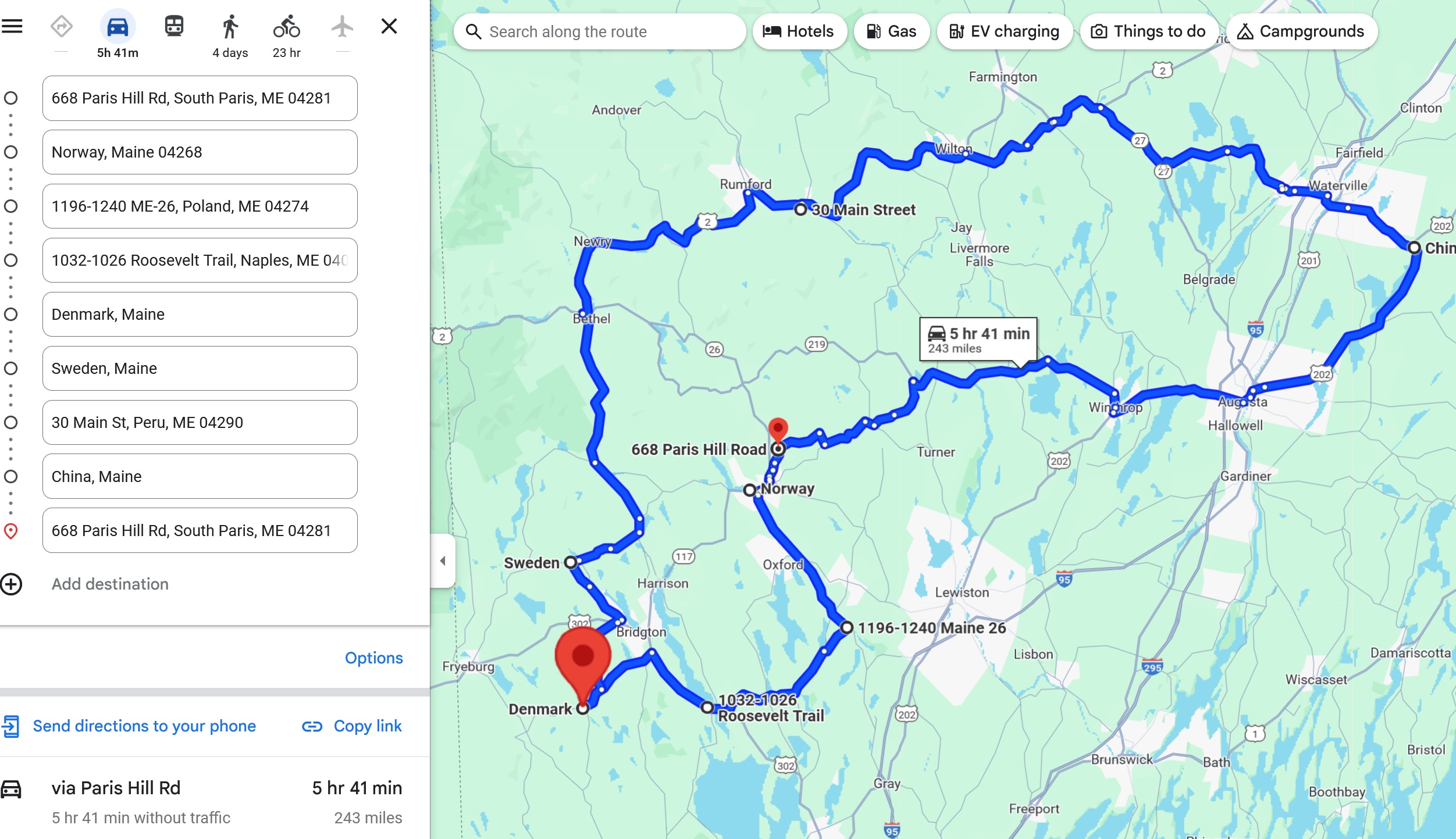
Since the OP didn't find it necessary, here's what this is about. That thick red line shows all of the US that the border patrol considers to be within 100 miles of the border, where they can stop, detain, and search you without probable cause. Chicago is actually over 200 miles from the border, but they treat the shore of Lake Michigan as the border.
In case this isn't clear, it's the increase in the duration of daylight from March 1st to 31st, not the December solstice to the March equinox.
I don't understand this map... USA are mono-ethnicity? If so, we need to talk. Unless it is saying that China is mono-ethnicity, in that case we need to talk some more.
I can understand why Oppenheimer is trending hard in New Mexico but Mississippi for Barbie? I just don't get it especially since Barbie was born in New York City.
Not Quite Done Yet!
Subscribe Premium to Compare Your Stats with Others
| User | Result | Reward |
|---|---|---|
 | / 20 | |
| | / 20 | |


 No fees, cancel anytime


")
")


")
")