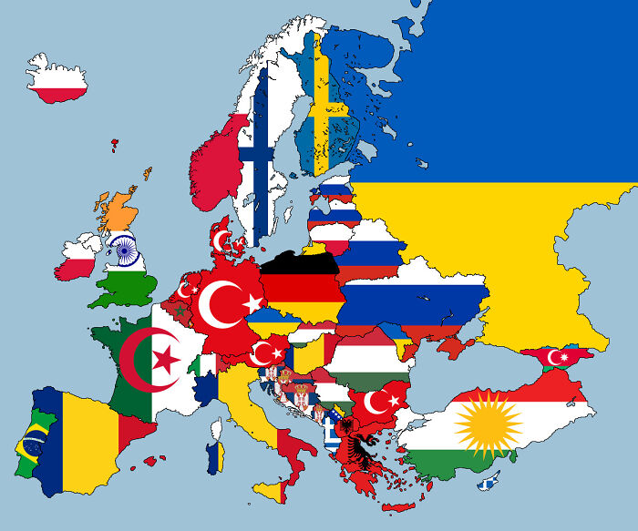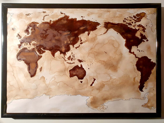
ADVERTISEMENT

We can’t stop feasting our eyes on gorgeous and interesting maps, and we know that some of you Pandas can’t either. That’s why we’ve put together another list of the coolest content to come from this subreddit that has a dedicated community of nearly 1.4 million fans.

And while we can’t mention the full name of the subreddit (the internet’s gotten a lot stricter in recent years when it comes to certain words! Gosh darn you, internet censorship!), we can tell you all about the project that was started up way back in 2011 by map lover Patrick McGranaghan. What started out as a labor of love has since grown into a dedicated niche for map geeks the world over.

Patrick, the founder of the subreddit dedicated to maps told Bored Panda about how we can improve our spatial awareness and navigational skills. "The older I get, the more I realize that spatial awareness just comes naturally to some people, and for others, it's a struggle," he said, highlighting that practice and repetition are key to honing this skill.

However, just like spell check can make our grammar skills go numb, so can GPS and easily accessible digital maps harm our ability to orient ourselves. "In a way, reliance on Google Maps has made us dumber. We let the navigation app do all the work for us and don't engage with making the decisions," Patrick said. Be sure to read on for the rest of our latest interview with the subreddit's founder, Patrick, below.

In the mood for some more amazing maps? We know you are! When you’re done upvoting your fave maps in this list, check out Bored Panda’s previous posts about the cartography-loving community here, here, and here.

More info: Reddit | Twitter | Tumblr

#1

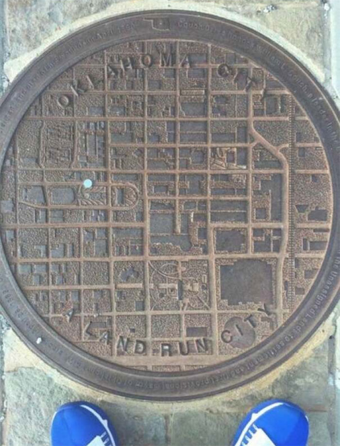
Oklahoma Man Hole Covers Have A City Map On, With A Blue Dot To Show Where You Are

Oklahoma Man Hole Covers Have A City Map On, With A Blue Dot To Show Where You Are

CatherineCortez Report

#3

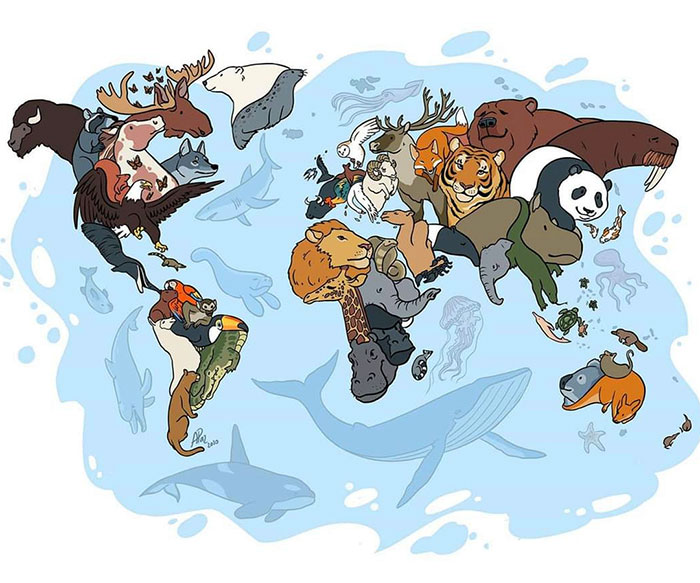
Animals Of The World Map

Animals Of The World Map

ShapeShiftingCats Report

"If you live in a place with a tall hill or some viewpoint, go up there some time and look around. Try to identify as many landmarks as you can. Notice where they are in relation to each other. Look for new landmarks that you've never noticed before and keep them in mind as you navigate your home town. If there are rivers or other features that cause chokepoints on bridges or highways, memorize all the bridges and where they go. In this way, you'll know the layout of your city and how to get around," Patrick gave us some awesome and practical advice on how to improve our navigation skills.
ADVERTISEMENT
#5

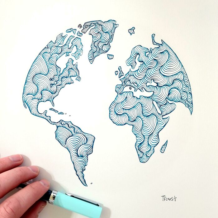
Someone Joked That Instead Of Google Earth I Should Make Doodle Earth. I Liked The Idea So I Gave It A Shot

Someone Joked That Instead Of Google Earth I Should Make Doodle Earth. I Liked The Idea So I Gave It A Shot

tfoust10 Report

#6

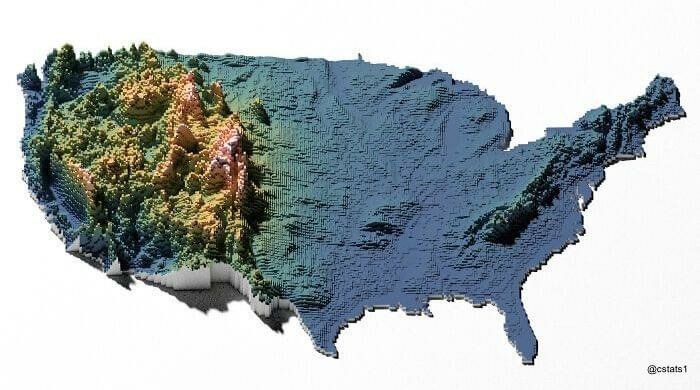
United States Elevation Map

United States Elevation Map

blntdfam Report

Bored Panda also had a chat with Patrick about the current Covid-19 situation worldwide. Vaccines are being rolled out, plenty of map-lovers would love to visit the places they've been staring at on their maps for a long time, but is it safe to travel yet? Patrick was very upfront that you have to trust your local medical and scientific experts in these matters.

"I think we all have to take precautions, get vaccinated, and avoid risky behaviors. That said, I think we need to remember that we're fighting to eradicate this disease and get back to a normal state of affairs. I really miss the freedom of travel. We're losing years of potential happiness to the lockdowns and at some point, we need to open up. Those are issues above my pay grade though and I hope it's sooner rather than later," he shared his take on the current climate.

ADVERTISEMENT
#7

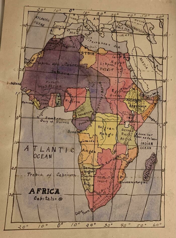
My Great Grandpa Drew This Map Of Africa In The 1910’s

My Great Grandpa Drew This Map Of Africa In The 1910’s

zherper Report

ADVERTISEMENT
#9

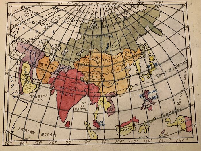
Since You All Liked My Great Grandpa’s Drawing Of Africa At Age 12, Here’s One He Did Of Asia (Ca. 1910’s)

Since You All Liked My Great Grandpa’s Drawing Of Africa At Age 12, Here’s One He Did Of Asia (Ca. 1910’s)

zherper Report

There are plenty of people out there who feel like everything's been mapped and Patrick's heard this response plenty of times when he's told then that he's a land surveyor and that he makes maps for a living. "People say, 'Hasn't everything been mapped?' The world is constantly changing and accurate spatial data is a fleeting thing. Google Maps certainly gives the impression that everything is mapped, but there is selection and generalization in their data," Patrick pointed out that there's a constant need to map and remap the world.

"Infrastructure is a key thing that we all rely on and don't realize it. The electricity to turn on your lights, the fiber that carries this message, the water that you drink. All those things are traveling to you above and below ground. Construction is constantly happening along this route. Knowing where to safely build is critical."

ADVERTISEMENT

He continued: "There are other themes that have spatial data too. Municipalities pass zoning and other restrictions all the time. Cities like London have an umbrella of rules about the preservation of old buildings, view-lines, noise nuisances, and other regulations. Making accurate maps is a constant struggle that is going to stay with us for a long time. As more things get built, knowing where these are located is important. Maintain the world's databases of spatial information is the task of the modern map-maker."

#11

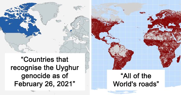
A Map Of All Of The World's Roads

A Map Of All Of The World's Roads

RossBoss31 Report

#12

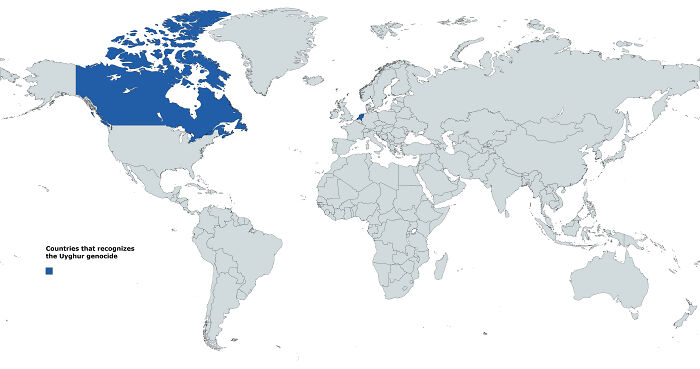
Countries That Recognises The Uyghur Genocide As Of February 26, 2021

Countries That Recognises The Uyghur Genocide As Of February 26, 2021

Blulien Report

During my previous chat with the founder of the subreddit, Patrick, he told me all about what sparked his passion for maps and how amateur cartographers can learn to create better maps. For Patrick, his love of maps started very early on in his life, all thanks to his father.

ADVERTISEMENT

“I developed my passion for maps very early. My family traveled and moved around a lot. My dad taught me how to read maps and I would help him navigate. I used to flip through our Rand McNally atlas to pass hours traveling across the countryside,” he shared earlier with Bored Panda.

#13

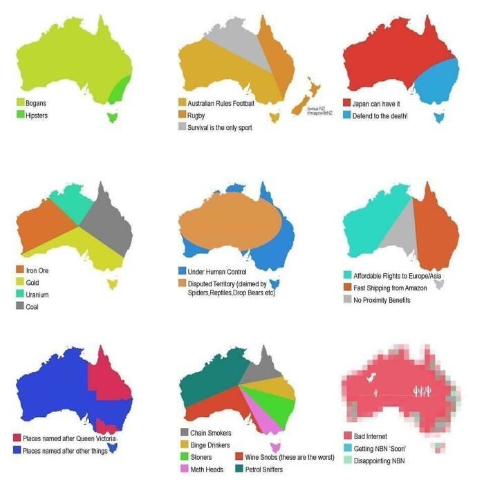
Some Alternate Maps Of Down Under

Some Alternate Maps Of Down Under

UggBootPimpJuice Report

#14

Map Of Most Photographed Places In The World

Map Of Most Photographed Places In The World

the-70s-kid Report

#15

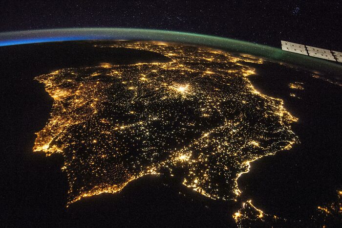
The Iberian Peninsula At Night By Nasa

The Iberian Peninsula At Night By Nasa

Homesanto Report

“Maps are invitations to explore and visit new places. They give security in the knowledge that there's a way to get to your destination. If all else fails, a map will be your guide," Patrick opened up about the romantic side of his passion for all things related to cartography.

#16

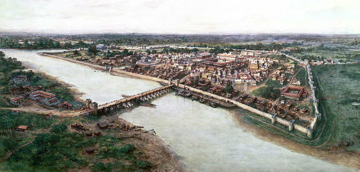
An Artists' Impression Of The Roman Port City Of Londinium, Established Between 47-50 Ad

An Artists' Impression Of The Roman Port City Of Londinium, Established Between 47-50 Ad

last_goodbye1 Report

ADVERTISEMENT
#17

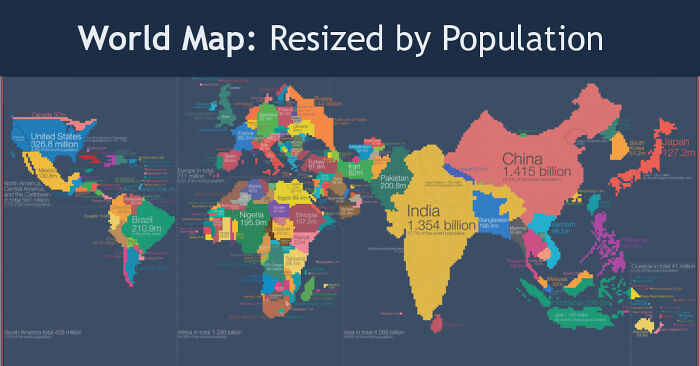
World Map Resized According To Population

World Map Resized According To Population

fasterthanksi Report

Add photo comments
POST
Bobert Robertson
Community Member
3 years ago DotsCreated by potrace 1.15, written by Peter Selinger 2001-2017

As a Canadian, that map is pretty accurate to where most of us already live anyway.... the rest is (more or less) vacant, minus some sporadic beautiful towns in the territories.

View More Replies...
View more commentsArrow down menu
#18

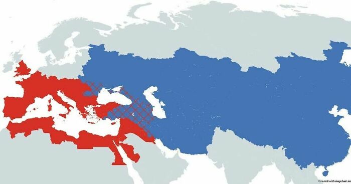
The Roman Empire vs. The Mongol Empire At Their Peaks

The Roman Empire vs. The Mongol Empire At Their Peaks

vladgrinch Report

Add photo comments
POST
Hans
Community Member
3 years ago DotsCreated by potrace 1.15, written by Peter Selinger 2001-2017

Quite impressive. At least over here, Asian history is not taught much in school.

View More Replies...
View more commentsArrow down menu

He actually came up with the idea to start the subreddit way back in 2011. At the time, he was living in a small flat in Taipei, in Taiwan. “I knew that I had a good idea and it felt almost electric. Like a fork in the road and your destiny is changing. When I moved back to the states I was able to find a career making maps (as a land surveyor) and I am grateful every day that I can do something that I love,” he shared how his excitement for the project grew from a single powerful idea that simply captivated him.

#19

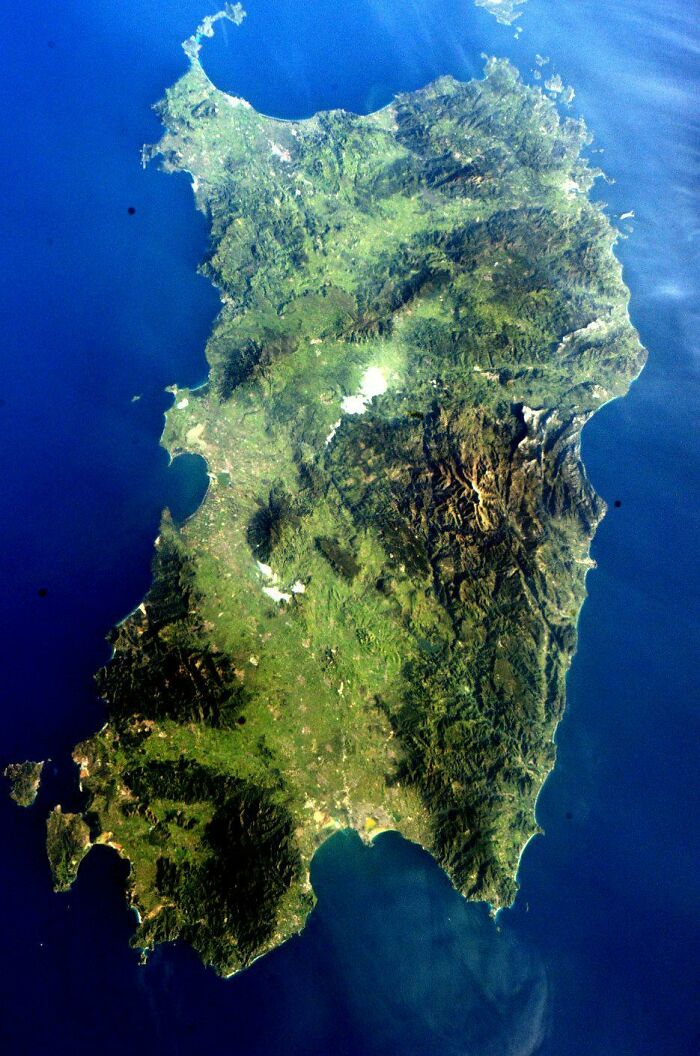
The Island Of Sardinia As Seen From The International Space Station

The Island Of Sardinia As Seen From The International Space Station

MXN006 Report

#20

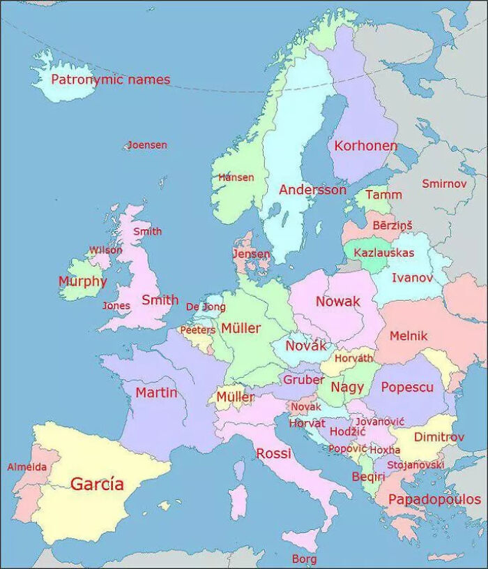
Most Popular Lastnames In Europe

Most Popular Lastnames In Europe

vitor350z Report

Add photo comments
POST
Phendrena
Community Member
3 years ago DotsCreated by potrace 1.15, written by Peter Selinger 2001-2017

We are the Borg. Resistance is Futile. We will add your biological and technological distinctiveness to our own. Your culture will adapt to service us.

H Edwards
Community Member
3 years ago DotsCreated by potrace 1.15, written by Peter Selinger 2001-2017

hehehe... but it's actually pronounced Borj with a soft G sound. Joseph Borg is the Maltese equivalent of John Smith.

Load More Replies...
Kadek Crocker
Community Member
3 years ago DotsCreated by potrace 1.15, written by Peter Selinger 2001-2017

This means that if a man named has a John has a son named Tom, Tom's last name will be Johnson. If John has a daughter named Samantha, her last name will be Johndóttir (dottir is icelandic for daughter)

Load More Replies...
Charlotte A.
Community Member
3 years ago DotsCreated by potrace 1.15, written by Peter Selinger 2001-2017

"Popular" might not be the right term seeing as most people get the name of their parents (or spouse). "Common" seems a better choice... (If I may do a bit of nitpicking.)

Erik Granqvist
Community Member
3 years ago DotsCreated by potrace 1.15, written by Peter Selinger 2001-2017

I am almost sure that no one on Iceland has the name "patronymic names" in their name.

AdoptALLtheKitties
Community Member
3 years ago DotsCreated by potrace 1.15, written by Peter Selinger 2001-2017

We know that the popular names change over time as well, with the increase/decrease of family sizes/ends of lineages. What time snipet does this represent?
CORLEONE
Community Member
3 years ago DotsCreated by potrace 1.15, written by Peter Selinger 2001-2017
Beqiri - That is not true the most popular last name in Albania is Hoxha

Dynein
Community Member
3 years ago DotsCreated by potrace 1.15, written by Peter Selinger 2001-2017

At least in Germany, the way you factor in spelling makes a difference. The equivalent of "Smith" has various possible spellings - if you count all of them together, that surname is actually the most common.

Lina Touba
Community Member
3 years ago DotsCreated by potrace 1.15, written by Peter Selinger 2001-2017

lol the the last name of the only finnish person I know is Kohonen

Cip IESAN
Community Member
3 years ago DotsCreated by potrace 1.15, written by Peter Selinger 2001-2017

I'm from Romania and I know only 5 families named Popescu.

Bobert Robertson
Community Member
3 years ago DotsCreated by potrace 1.15, written by Peter Selinger 2001-2017

I've never met a Papadopoulos, Beqiri, Stojanovsjki, Borg.... Actually most of these

H Edwards
Community Member
3 years ago DotsCreated by potrace 1.15, written by Peter Selinger 2001-2017

and. yet. Have you ever been to Malta? or any of the places where you would encounter those particular surnames? I can assure you the there are plenty of people called Borg in Malta, despite your own little experience of the world.

Load More Replies...
View More Replies...
View more commentsArrow down menu
ADVERTISEMENT
#21

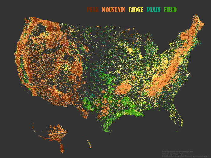
Place Names That Contain The Word 'Peak', 'Mountain', 'Ridge', 'Plain' And 'Field' In The United States

Place Names That Contain The Word 'Peak', 'Mountain', 'Ridge', 'Plain' And 'Field' In The United States

AJgloe Report

Patrick was very friendly in sharing some tips and tricks on how we can all make our maps look better. For instance, he drew attention to the fact that plenty of amateurs have great ideas, are overflowing with creativity, but their execution needs a bit of work. That way, the maps can end up looking gorgeous and less “hasty and skeletal.”

"It is not that they are bad, it's just that they don't know that they can make their maps so much better. I'm talking about things like fonts and information boxes, detail and vicinity maps, adding gradients to water features, thoughtful color choices, shadows behind place markers. The subtleties are what make maps exquisite," the founder of the subreddit explained.

#22

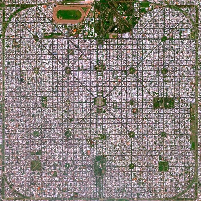
La Plata.. Buenas Aires.. Argentina

La Plata.. Buenas Aires.. Argentina

mitozzzzzz Report

Add photo comments
POST
Phendrena
Community Member
3 years ago DotsCreated by potrace 1.15, written by Peter Selinger 2001-2017

Impressive urban planning. This is a clipped and rotated shot though. The road running as a diagonal from the Northwest to Southeast actually runs North to South.

View More Replies...
View more commentsArrow down menu
#23

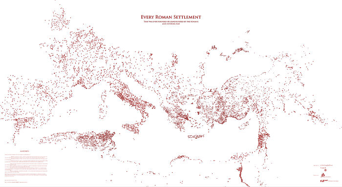
Every Roman Settlement, And Nothing Else

Every Roman Settlement, And Nothing Else

ImUsingDaForce Report

ADVERTISEMENT

"The best way to learn how to do these things is to look at lots of maps and see how other cartographers solve these problems. Imitate the masters. Read a few books on cartography and design. Some of the books that influenced me are 'Info We Trust' by RJ Andrews, 'Cartography' by Kenneth Field, and 'Things Maps Don't Tell Us' by Armin Lobeck. If you can integrate the ideas in these books you'll be a league above the average amateur cartographer."

Earlier, Patrick shared that he plans to start traveling again once the Covid-19 pandemic dies down a bit. On his bucket list is a trip to the Baltics, specifically, to the Soviet map store in Latvia.

#25

In A Straight Line You Can Go From Belguim To France 11 Times

In A Straight Line You Can Go From Belguim To France 11 Times

Percentagon Report

Add photo comments
POST
Katz
Community Member
3 years ago DotsCreated by potrace 1.15, written by Peter Selinger 2001-2017

How many of you counted the connection points? Just to be sure it is correctly referred in heading :)

View More Replies...
View more commentsArrow down menu
#26

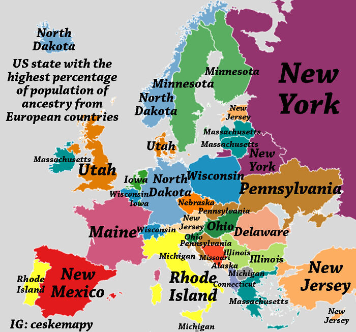
In Which State You Can Find The Highest Percentage Of People With Ancestry From Every European Country?

In Which State You Can Find The Highest Percentage Of People With Ancestry From Every European Country?

ceskemapy Report

Add photo comments
POST
Hans
Community Member
3 years ago DotsCreated by potrace 1.15, written by Peter Selinger 2001-2017

It would be interesting to also see the numbers along with this...

View More Replies...
View more commentsArrow down menu
#27

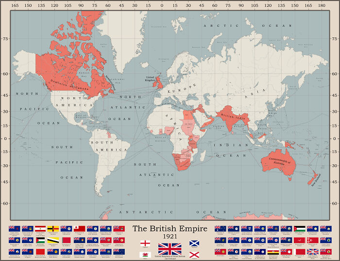
The British Empire At It's Territorial Peak

The British Empire At It's Territorial Peak

freddyfredric Report

Meanwhile, keep an eye out for the subreddit’s upcoming 10th birthday. The community will be celebrating the anniversary on its founding day, May 21. We can’t wait for the big day!

ADVERTISEMENT

Be sure to give the subreddit a follow to stay up to date with the community’s latest posts, dear Pandas. And we also can’t wait to hear which of the maps featured here were your favorite and why. Got any amateur maps to share with us? Post them in the comment section for everyone else to see.

#28

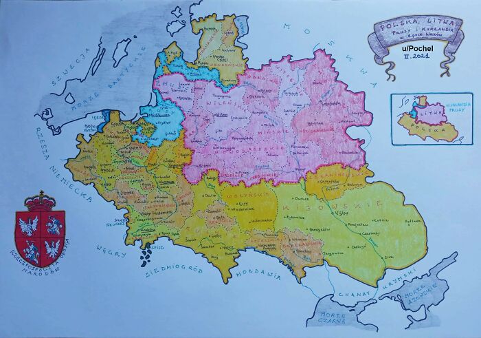
Hand-Drawn Map Of The Polish-Lithuanian Commonwealth In 1618, By Me

Hand-Drawn Map Of The Polish-Lithuanian Commonwealth In 1618, By Me

Pochel Report

#29

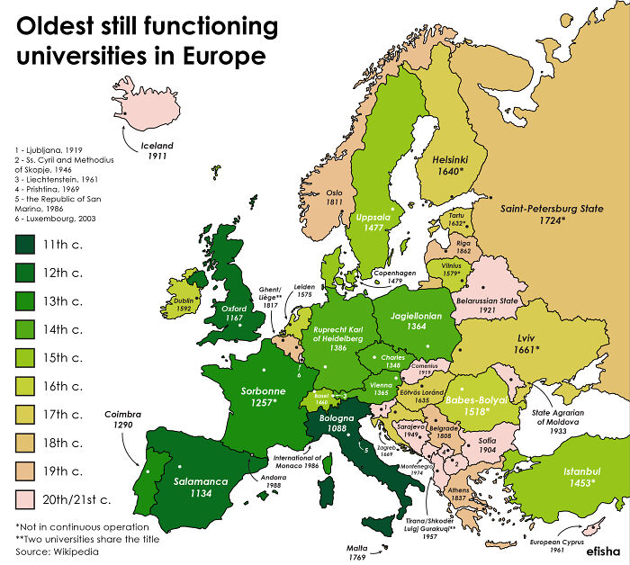
Oldest Still Open Universities In Europe (The Word University Is Omitted On The Map)

Oldest Still Open Universities In Europe (The Word University Is Omitted On The Map)

efisha Report

Add photo comments
POST
Jos Poisquet
Community Member
3 years ago DotsCreated by potrace 1.15, written by Peter Selinger 2001-2017

Belgium: not correct. Catholic university of Louvain (Katholieke Universiteit Leuven) founded in 1425. Ranking 45 worldwide!

View More Replies...
View more commentsArrow down menu
#30

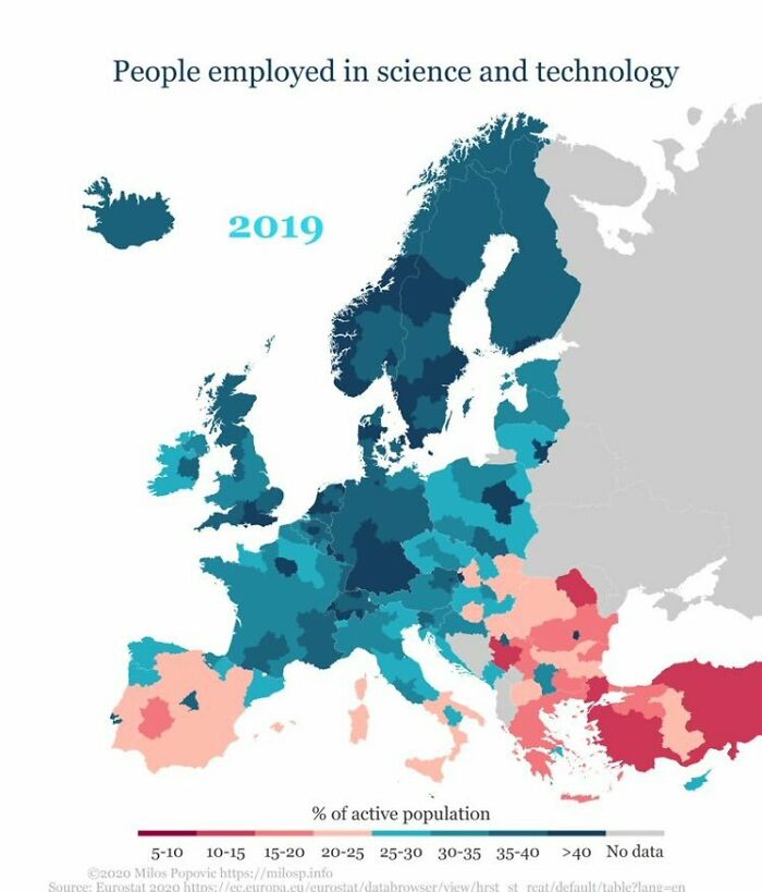
People Employed In Science And Technology In Europe

People Employed In Science And Technology In Europe

betoelpro Report

Continue reading with Bored Panda Premium
Unlimited content
Ad-free browsing
Dark mode
#31

Un Member Country That Does Not Recognise China

Un Member Country That Does Not Recognise China

Indic_historie Report

#32

Nobody Lives Here - Norway: Green Blocks Of 25km2 Where Nobody Lives

Nobody Lives Here - Norway: Green Blocks Of 25km2 Where Nobody Lives

eauctomisho Report

ADVERTISEMENT
#34

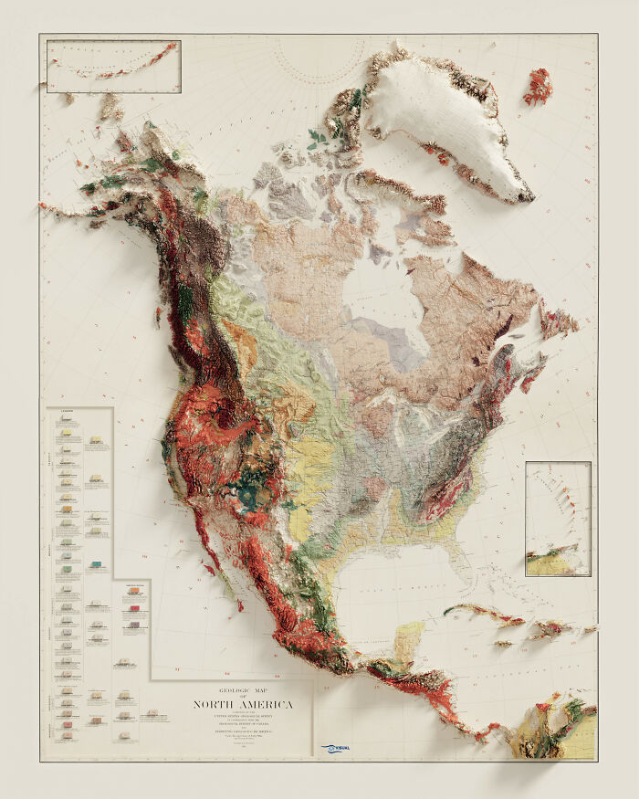
Geological Map Of North America

Geological Map Of North America

czn9001 Report

Add photo comments
POST
Mihai Mara
Community Member
3 years ago DotsCreated by potrace 1.15, written by Peter Selinger 2001-2017

Looks awesome, I am sure it took quite some time and dedication to complete.
View more commentsArrow down menu
#35

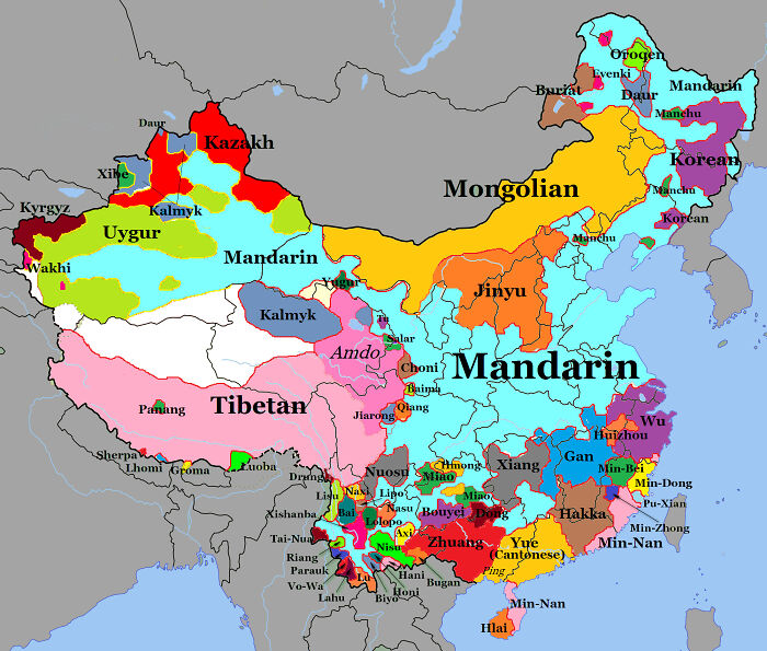
Language Map Of China

Language Map Of China

marofendre Report

#36

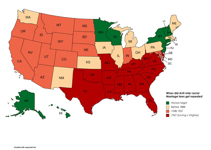
When Did Interracial Marriage Become Legal In Each U.s State?

When Did Interracial Marriage Become Legal In Each U.s State?

BLAZENIOSZ Report

Add photo comments
POST
Sum Guy
Community Member
3 years ago DotsCreated by potrace 1.15, written by Peter Selinger 2001-2017

I'm not saying Canada had a good influence on the north... the map says it

View more commentsArrow down menu
#37

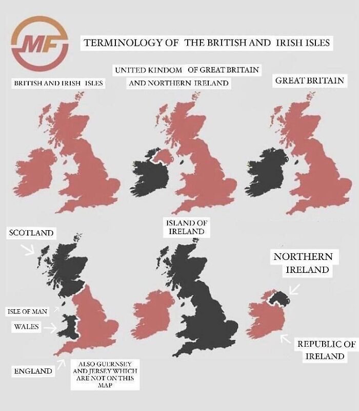
Terminology Of The British And Irish Isles

Terminology Of The British And Irish Isles

phantom_1c3man Report

#38

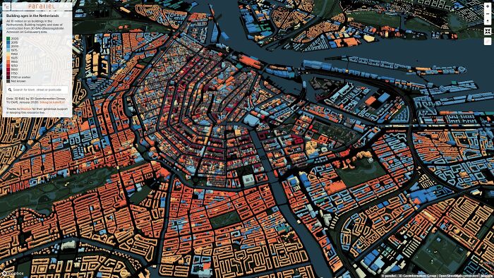
Central Amsterdam In 3D, With Buildings Coloured By Age

Central Amsterdam In 3D, With Buildings Coloured By Age

Litvi Report

#39

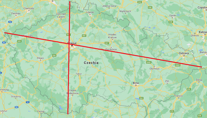
If You Connect The Easternmost Point With The Westernmost Point And The Northernmost With The Southernmost In Czechia, Prague Lies Almost Perfectly At The Intersection

If You Connect The Easternmost Point With The Westernmost Point And The Northernmost With The Southernmost In Czechia, Prague Lies Almost Perfectly At The Intersection

Aglaz Report

Add photo comments
POST
Aroha
Community Member
3 years ago DotsCreated by potrace 1.15, written by Peter Selinger 2001-2017

I personally wish people didn't say Czechia... I still stubbornly will use Czech Republic :D.

View More Replies...
View more commentsArrow down menu
#40

The Longest Distance You Can Travel Between Two Points In Straight Line Without Crossing Any Ocean Or Any Major Water Bodies

The Longest Distance You Can Travel Between Two Points In Straight Line Without Crossing Any Ocean Or Any Major Water Bodies

rmuradov Report

#41

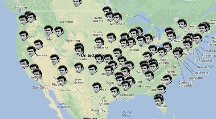
Places Where Johnny Cash Went In The Song "I've Been Everywhere"

Places Where Johnny Cash Went In The Song "I've Been Everywhere"

keith2301 Report

ADVERTISEMENT
#42

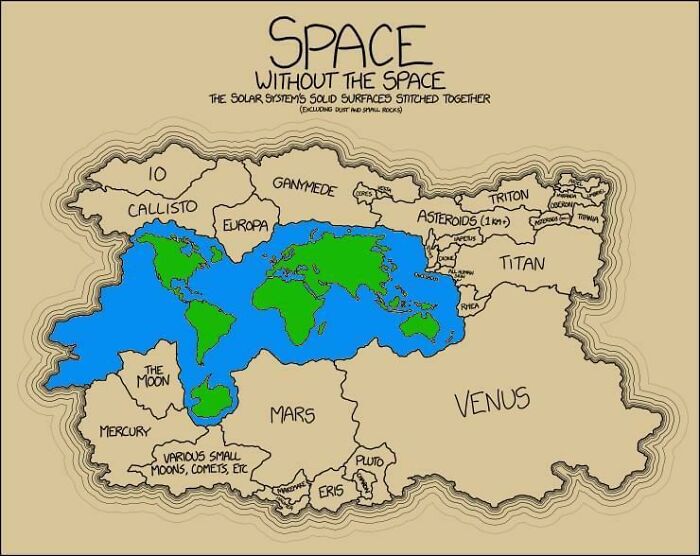
The Solar Systems Solid Surfaces Stitched Together

The Solar Systems Solid Surfaces Stitched Together

therocketflyer Report

#43

9 Ways To Divide Kazakhstan

9 Ways To Divide Kazakhstan

ShadowZ100 Report

Add photo comments
POST
The-JoeBai
Community Member
3 years ago DotsCreated by potrace 1.15, written by Peter Selinger 2001-2017

So the laidback people are the ones doing bride kidnappings, according to this?!

View more commentsArrow down menu
#44

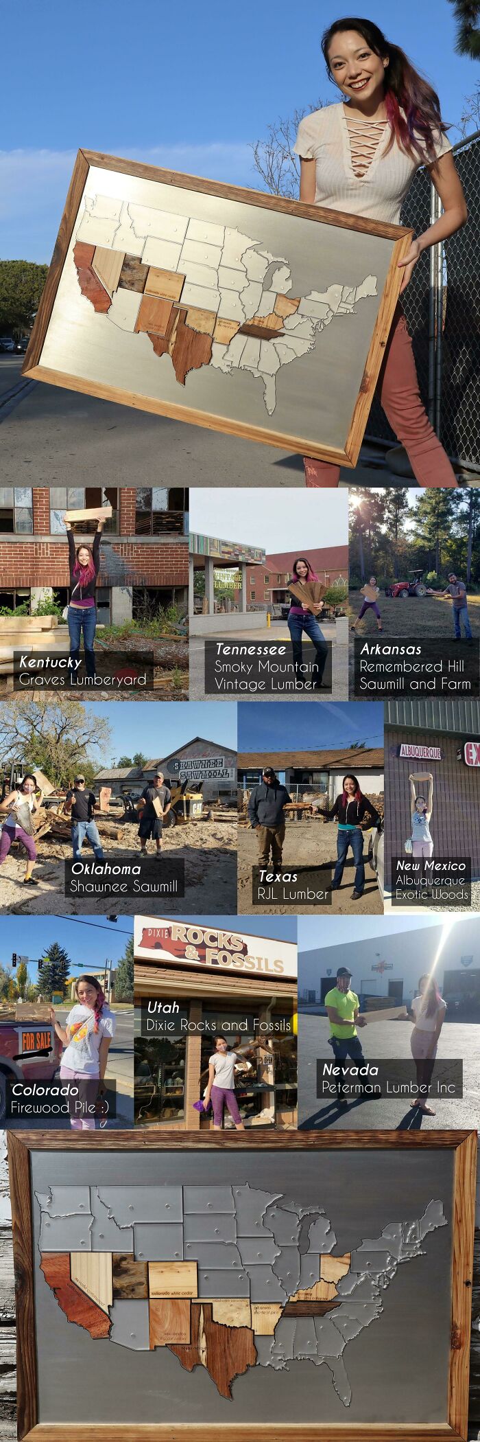
I Drove Across The USA Visiting A Sawmill In Every State And Made A Map Of Local Woods!

I Drove Across The USA Visiting A Sawmill In Every State And Made A Map Of Local Woods!

Physical-Order Report

#45

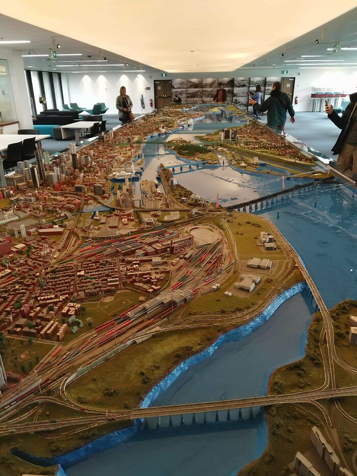
Huge Scale Model Of The Port Of Montreal At The Port Hq

Huge Scale Model Of The Port Of Montreal At The Port Hq

Bri-guy15 Report

#46

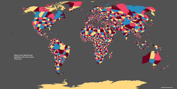
Map Of The World's Subdivisions That Satisfies The Four Color Theorem

Map Of The World's Subdivisions That Satisfies The Four Color Theorem

DarkerThanAzure Report

#47

How Europe Is Classified By United Nations

How Europe Is Classified By United Nations

Arthur_Sebastian_703 Report

#48

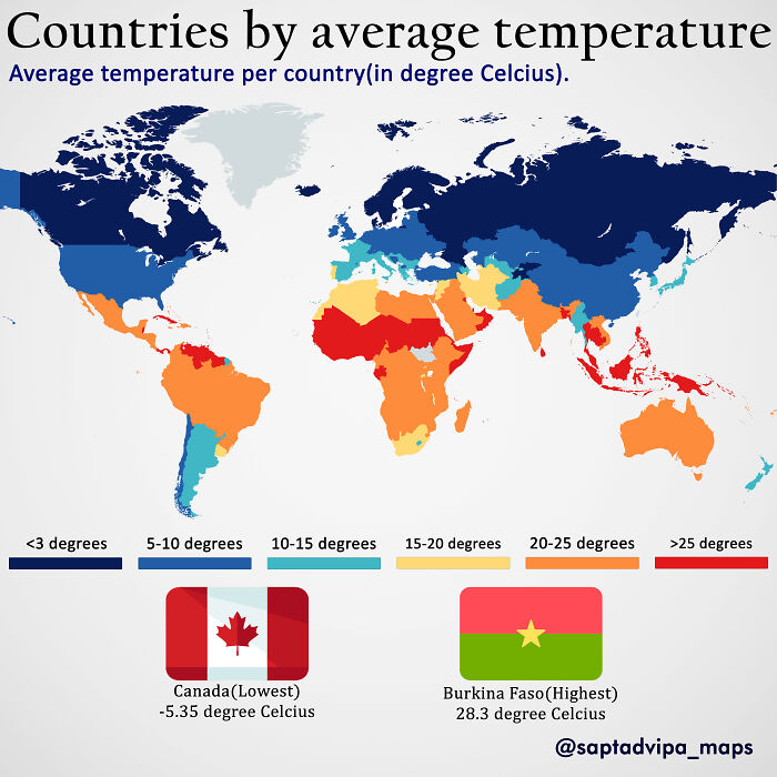
Average Temperature By Countries

Average Temperature By Countries

Saptadvipamaps Report

Add photo comments
POST
Tiny Dynamine
Community Member
3 years ago DotsCreated by potrace 1.15, written by Peter Selinger 2001-2017

This will tie in very closely with skin tones of people, which shows why we are the way we are. That is all that skin tones tell us. #endracism

View more commentsArrow down menu
#49

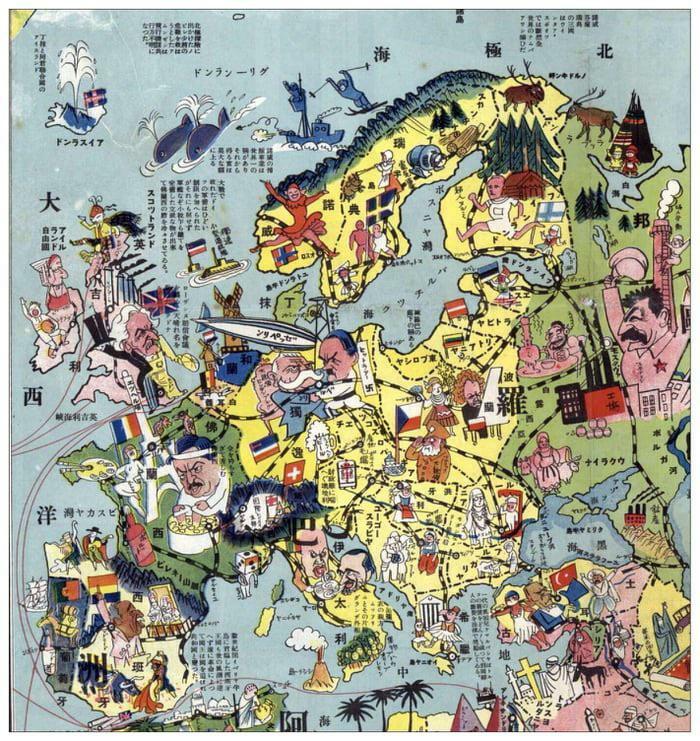
A Japanese Map Of European Stereotypes, 1932

A Japanese Map Of European Stereotypes, 1932

AnonAf21 Report

ADVERTISEMENT
#50

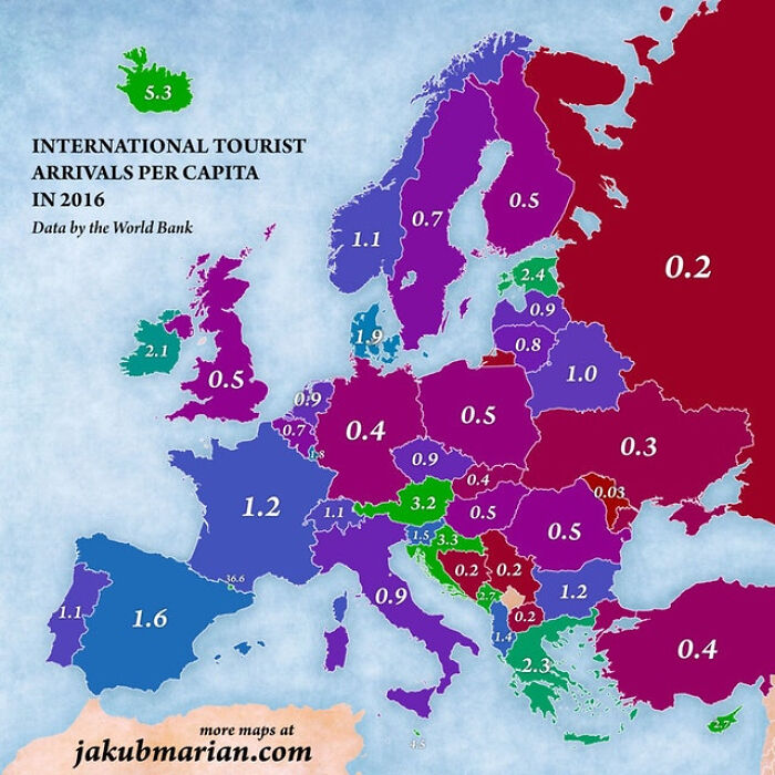
Number Of Turists Per Capita Of Every European Country

Number Of Turists Per Capita Of Every European Country

LEWKIK Report

Add photo comments
POST
Shelp
Community Member
3 years ago DotsCreated by potrace 1.15, written by Peter Selinger 2001-2017

France has the most tourist arrivals of the World, followed by Spain. XX per capita is always a weird way to show things!

View More Replies...
View more commentsArrow down menu
#51

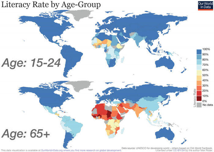
Literacy Rate By Age Group Map

Literacy Rate By Age Group Map

Mousa_m3 Report

Add photo comments
POST
Sum Guy
Community Member
3 years ago DotsCreated by potrace 1.15, written by Peter Selinger 2001-2017

It's nice to see my home country, Eswatini has the same colour as European countries... at least in the 15-24 age range

View More Replies...
View more commentsArrow down menu
#52

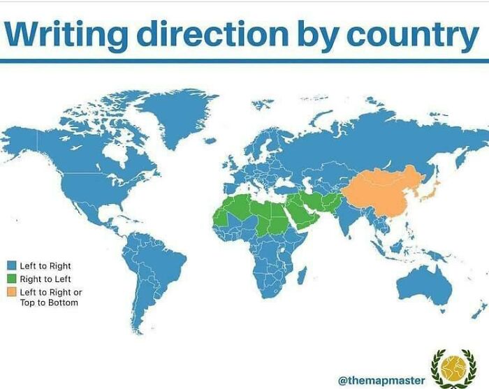
Writing Direction By Countries

Writing Direction By Countries

mccheerr Report

#53

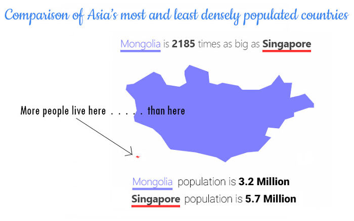
Singapore vs. Mongolia

Singapore vs. Mongolia

Cautious_Door2670 Report

Add photo comments
POST
Fred L.
Community Member
3 years ago DotsCreated by potrace 1.15, written by Peter Selinger 2001-2017

Also about half the population of Mongolia lives in the capital city.

#54

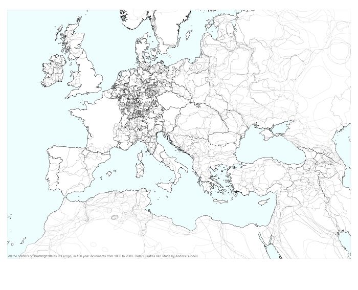
1000 Years Of National Borders In Europe, Overlaid On One Map

1000 Years Of National Borders In Europe, Overlaid On One Map

Arthur_Sebastian_703 Report

#55

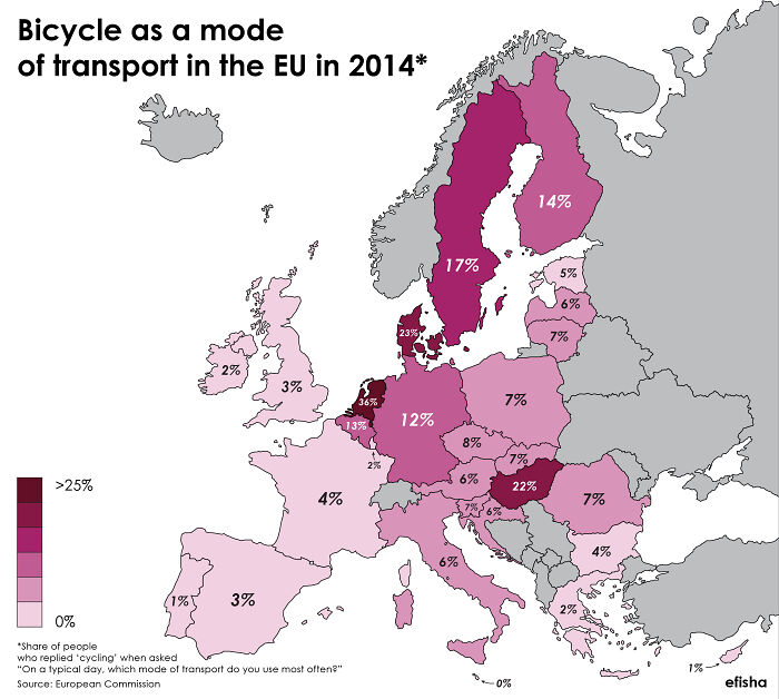
How Many People In The Eu Use Bicycles As Their Main Mode Of Transport?

How Many People In The Eu Use Bicycles As Their Main Mode Of Transport?

efisha Report

#56

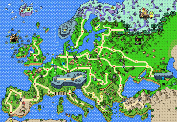
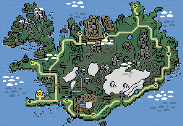
Iceland In The Style Of Super Mario World

Iceland In The Style Of Super Mario World

tuafeconf Report

Add photo comments
POST
Nate Hull
Community Member
3 years ago DotsCreated by potrace 1.15, written by Peter Selinger 2001-2017

Save the princess. Or just use the warp star to go anywhere other than here.

#57

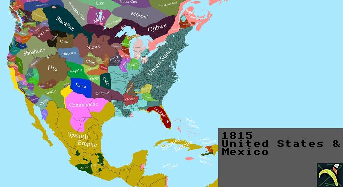
1815 United States And Mexico

1815 United States And Mexico

YeastCartography Report

Add photo comments
POST
Dave P
Community Member
3 years ago DotsCreated by potrace 1.15, written by Peter Selinger 2001-2017

Map is false. Spainish America extened well into the area labeled UTE, most of the north West was Russia at the time.

View More Replies...
View more commentsArrow down menu
ADVERTISEMENT
#58

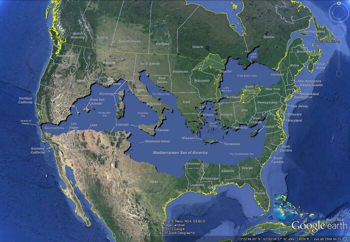
Mediterranean Sea Overlaid Onto The Us

Mediterranean Sea Overlaid Onto The Us

primeBrahe92 Report

#59

Capitol Riot: Which States Have Made The Most Arrests?

Capitol Riot: Which States Have Made The Most Arrests?

tomydenger Report

Add photo comments
POST
Losferatu
Community Member
3 years ago DotsCreated by potrace 1.15, written by Peter Selinger 2001-2017

Ah yes, Texas again leading the way, followed closely by Florida. Not surprised.

View More Replies...
View more commentsArrow down menu
#60

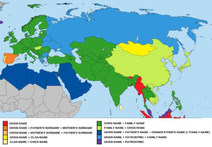
Map Of Traditional Naming Conventions In Eurasia

Map Of Traditional Naming Conventions In Eurasia

DrudenSoap Report

#61

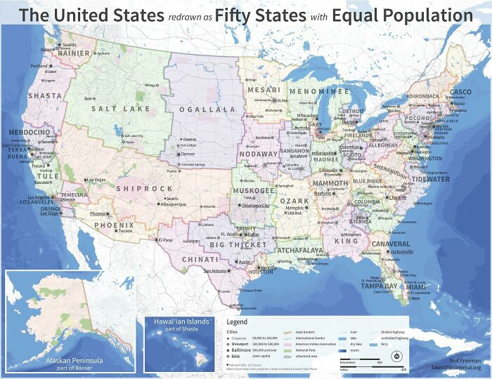
The United States Redrawn As Fifty States With Equal Population, 2010 Census

The United States Redrawn As Fifty States With Equal Population, 2010 Census

zver139 Report

#62

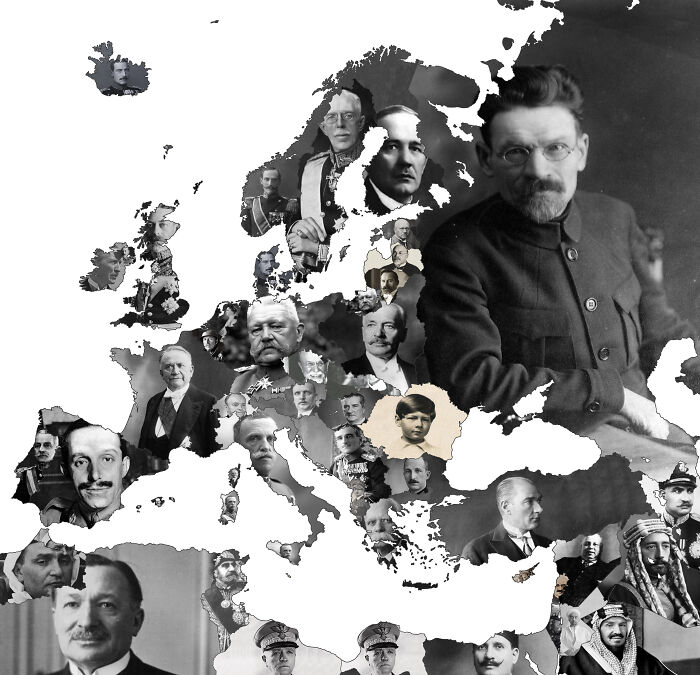
Map Of European Heads Of States (Presidents, Kings, Ect.) In January 1930, This Time Also Including Governors Of Colonies. Yes, King Michael Of Romania Was Only 9 At This Point
Map Of European Heads Of States (Presidents, Kings, Ect.) In January 1930, This Time Also Including Governors Of Colonies. Yes, King Michael Of Romania Was Only 9 At This Point
stanthefax Report

Add photo comments
POST
Shelp
Community Member
3 years ago DotsCreated by potrace 1.15, written by Peter Selinger 2001-2017
I guess the guy in the USSR was the official... president of that time (?) Because that's definitely not Stalin

View More Replies...
View more commentsArrow down menu
#63

Maps Of The Netherlands Between The 1st Century Ad (Left) And 10th Century Ad (Right) Showing The Effect Of The Constantly Sinking Coastline

Maps Of The Netherlands Between The 1st Century Ad (Left) And 10th Century Ad (Right) Showing The Effect Of The Constantly Sinking Coastline

sylvyrfyre Report

#64

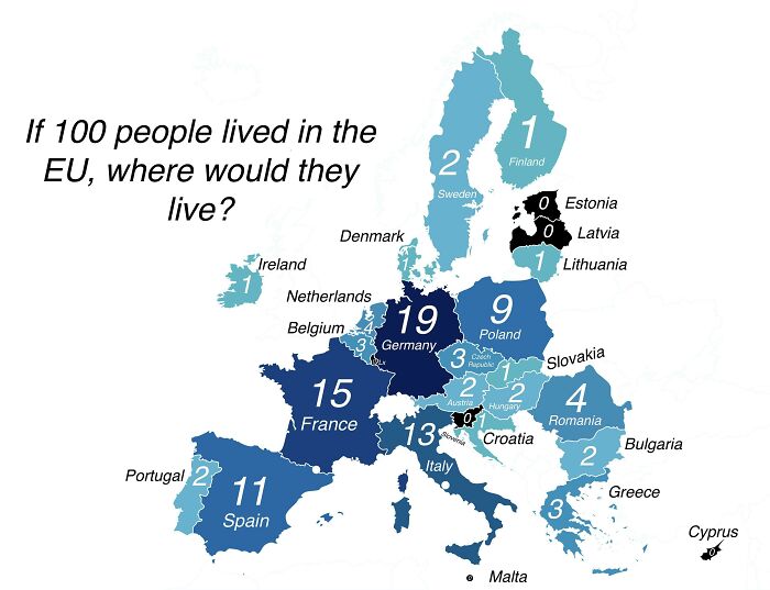
If 100 People Lived In The Eu, Where Would They Live?

If 100 People Lived In The Eu, Where Would They Live?

NationalFront_Disco Report

#65

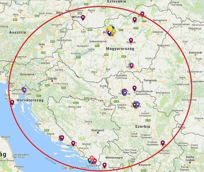
All Men's Olympic Gold Medal Winners Since 2000 In Water-Polo Were Born In This Area

All Men's Olympic Gold Medal Winners Since 2000 In Water-Polo Were Born In This Area

uscrewed38 Report

ADVERTISEMENT
#66

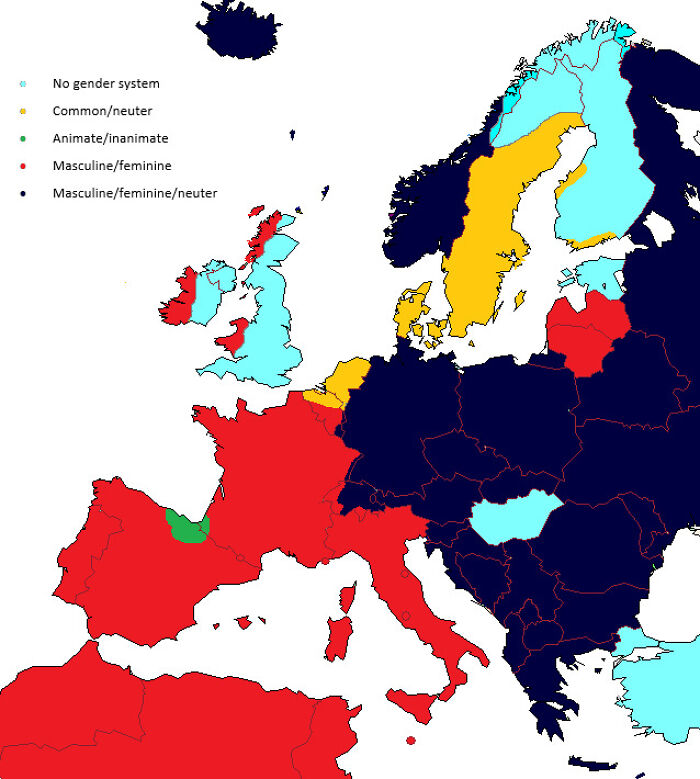
Gender In European Languages

Gender In European Languages

northbynortheast31 Report

Add photo comments
POST
Vuun
Community Member
3 years ago DotsCreated by potrace 1.15, written by Peter Selinger 2001-2017

This applies to nouns only. Obviously, there are gendered pronouns in English.

View More Replies...
View more commentsArrow down menu
#67

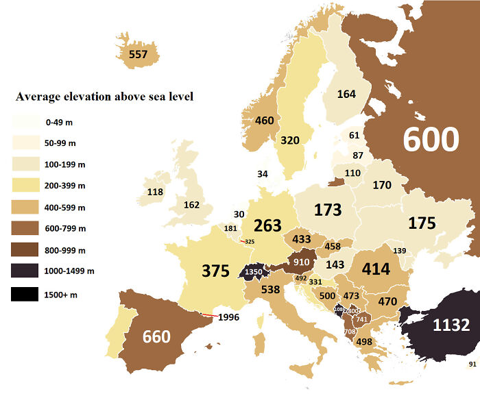
Average Elevation Above Sea Level Of European Countries

Average Elevation Above Sea Level Of European Countries

casburism Report

Add photo comments
POST
Sara Rodrigues
Community Member
3 years ago DotsCreated by potrace 1.15, written by Peter Selinger 2001-2017

Average elevation is the worst possible way to show the topography of the different countries, as geology doesn't care about borders. It would be better to show a topographic or bathymetric map of Europe.

View More Replies...
View more commentsArrow down menu
#68

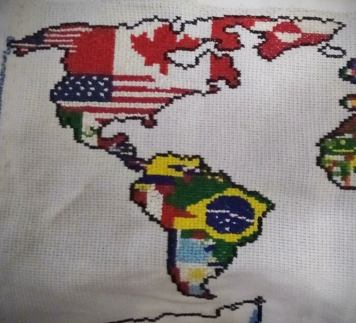
Someone Told Me To Post My Cross Stitched Map Here

Someone Told Me To Post My Cross Stitched Map Here

TheDoltio Report

Add photo comments
POST
Lance d'Boyle
Community Member
3 years ago DotsCreated by potrace 1.15, written by Peter Selinger 2001-2017

Huh, someone told me to look for a cross stitched map here. I think we're being set up.

View More Replies...
View more commentsArrow down menu
#70

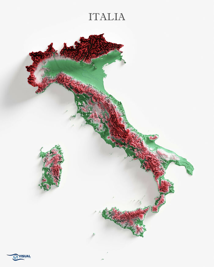
Made A Shaded Relief Map Of Italy

Made A Shaded Relief Map Of Italy

visualgeomatics Report

Add photo comments
POST
CrunChewy McSandybutt
Community Member
3 years ago DotsCreated by potrace 1.15, written by Peter Selinger 2001-2017

I recently saw a video of drones flying around the Italian Alps and holy moly that was awe-inspiring.

View more commentsArrow down menu
#71

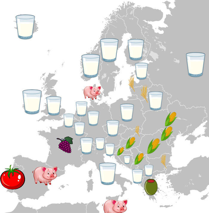
European Countries By Most Produced Agricultural Product By Value

European Countries By Most Produced Agricultural Product By Value

visvis Report

#72

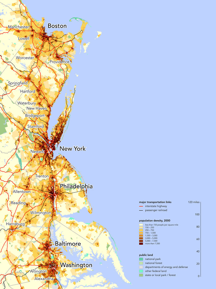
Population Density Of The Northeast Megalopolis, Home To 56 Million People

Population Density Of The Northeast Megalopolis, Home To 56 Million People

cheeseface35 Report

#73

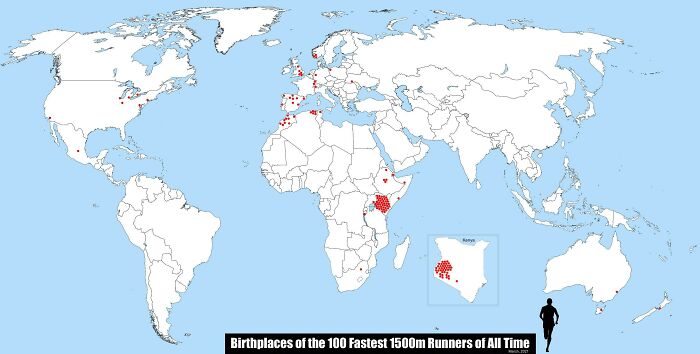
Birthplaces Of The 100 Fastest 1500m Runners Of All Time

Birthplaces Of The 100 Fastest 1500m Runners Of All Time

animbicile Report

Add photo comments
POST
Sum Guy
Community Member
3 years ago DotsCreated by potrace 1.15, written by Peter Selinger 2001-2017

If you open google maps, you'll see why south west kenya produces high lung capacity athletes

View More Replies...
View more commentsArrow down menu
ADVERTISEMENT
#74

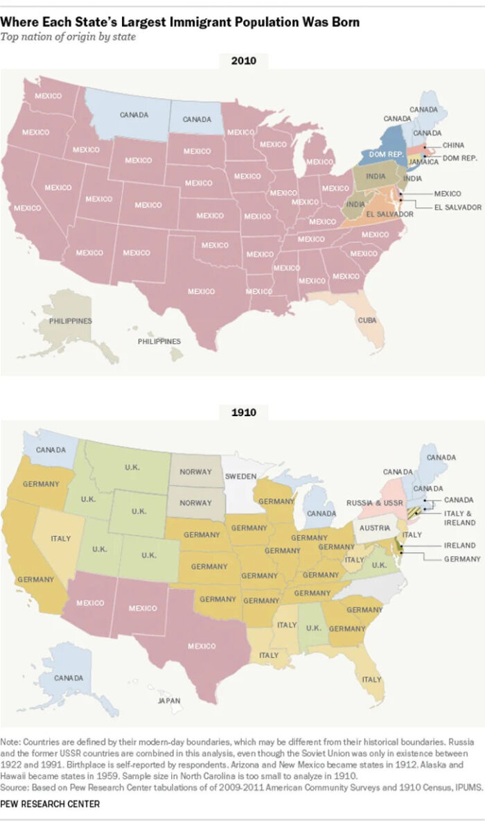
Where Each State's Largest Immigrant Population Was Born, 2010 vs. 1910

Where Each State's Largest Immigrant Population Was Born, 2010 vs. 1910

redditmanagement_ Report

#75

Floor Plan Of The World - Room Size According To Population

Floor Plan Of The World - Room Size According To Population

frankenhip Report

#76

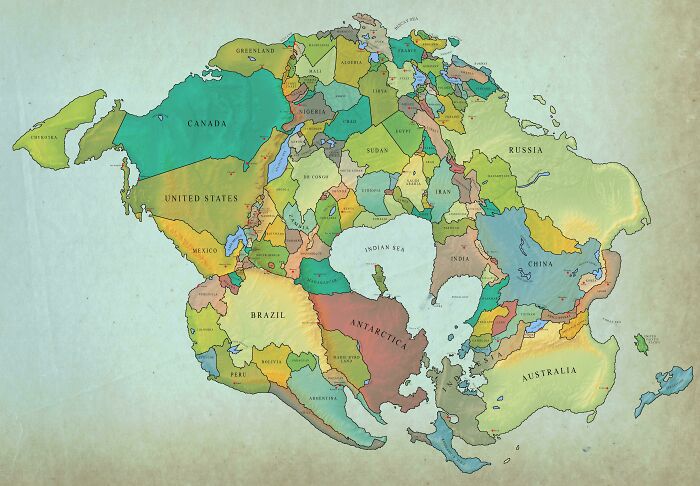
Earth In 250 Million Years With Current Borders

Earth In 250 Million Years With Current Borders

dr_razi Report

Add photo comments
POST
Anna McHugh
Community Member
3 years ago DotsCreated by potrace 1.15, written by Peter Selinger 2001-2017

Might make social distancing a bit difficult. Mind you, having Brazil next to Antarctica probably isn't a bad idea.

View more commentsArrow down menu
#77

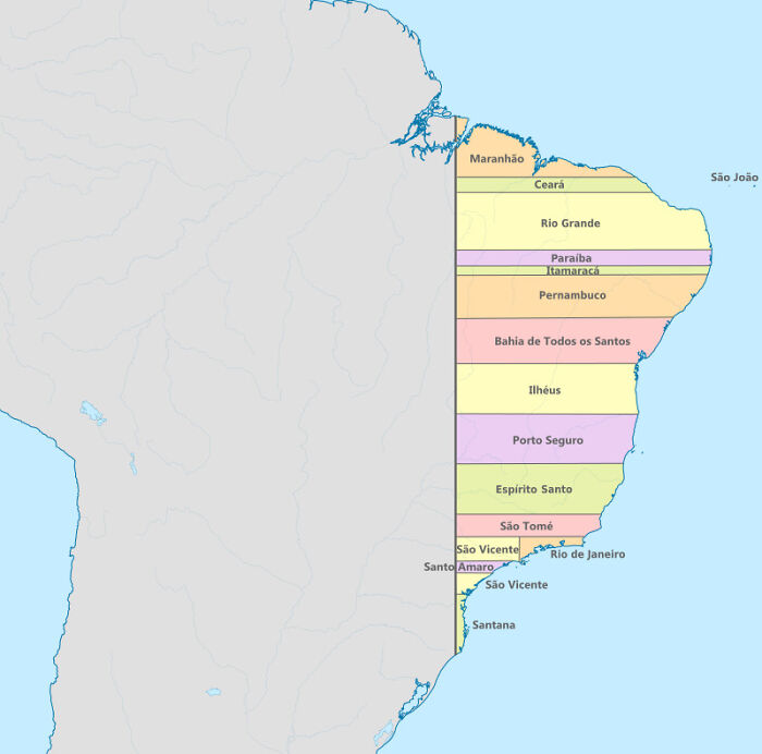
Brazil Had Straight Borders In 1534

Brazil Had Straight Borders In 1534

TheOther36 Report

Add photo comments
POST
Shelp
Community Member
3 years ago DotsCreated by potrace 1.15, written by Peter Selinger 2001-2017

Well, those were probably claims, rather than real provinces. The settlers controlled a small settlement on the shore, and some kind of edict granted them the exclusivity of the hinterland up to x?km westwards.

View more commentsArrow down menu
#78

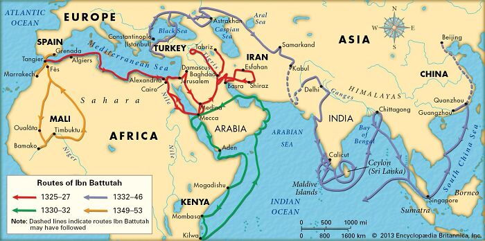
An Example Of World Exploration By Non-Europeans

An Example Of World Exploration By Non-Europeans

Norcan987 Report

#79

Isochronic Map Of Travel Times Between Paris And The Main Cities Of France In 1700s (Map Made In 1898)

Isochronic Map Of Travel Times Between Paris And The Main Cities Of France In 1700s (Map Made In 1898)

Petrarch1603 Report

Add photo comments
POST
Gemma
Community Member
3 years ago DotsCreated by potrace 1.15, written by Peter Selinger 2001-2017

350 hours? Ouch. Some of those journeys would've been quicker by sea, I assume.

#80

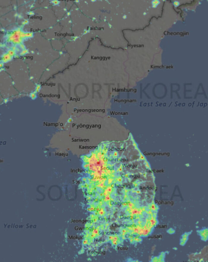
Light Pollution In North Korea vs. South Korea

Light Pollution In North Korea vs. South Korea

cabousetery Report

#81

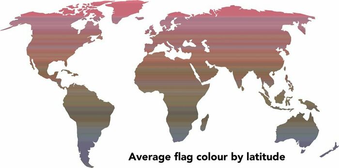
Average Flag Color By Latitude

Average Flag Color By Latitude

ParadoxicalCabbage Report

Add photo comments
POST
Jon S.
Community Member
3 years ago DotsCreated by potrace 1.15, written by Peter Selinger 2001-2017

That's the most random metric to map and most random why to convey the information

View more commentsArrow down menu
ADVERTISEMENT
#82

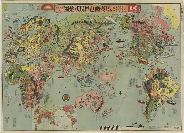
Japanese Pictorial Map Of The World From 1933

Japanese Pictorial Map Of The World From 1933

theonlynek Report

Add photo comments
POST
#83

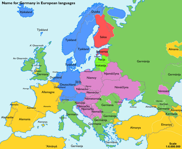
The Name For 'Germany' In European Languages

The Name For 'Germany' In European Languages

CamR203 Report

Add photo comments
POST
Jon S.
Community Member
3 years ago DotsCreated by potrace 1.15, written by Peter Selinger 2001-2017

I know germany and allerman variants come from germanic tribes. 'Saksa' could be saxon?. What does the 'Niemcy' and 'Vacija' variants come from?

View more commentsArrow down menu
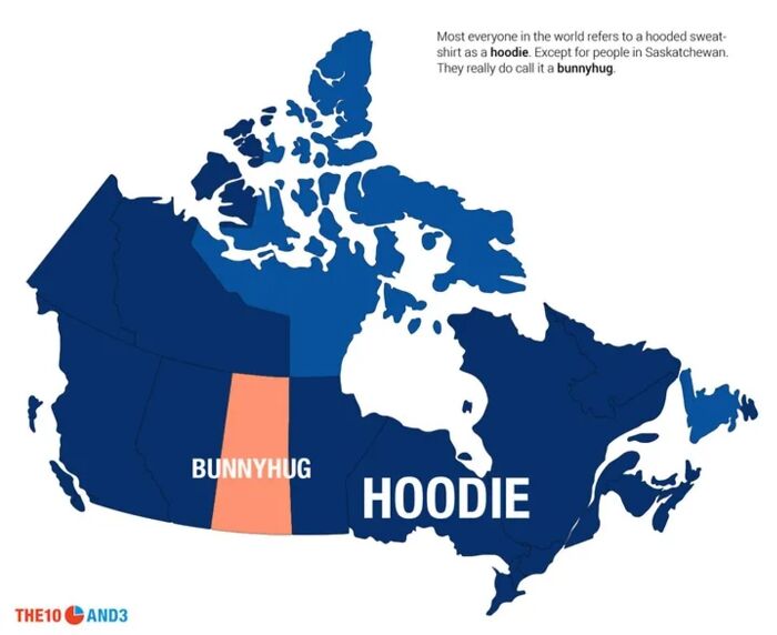
#84

What Canadians Call A Sweater With A Hood

What Canadians Call A Sweater With A Hood

Pissmitts Report

Add photo comments
POST
Aunt Messy
Community Member
3 years ago DotsCreated by potrace 1.15, written by Peter Selinger 2001-2017

From Alberta - where they're called "Kangaroo jackets", because of the front pocket.

View more commentsArrow down menu
#85

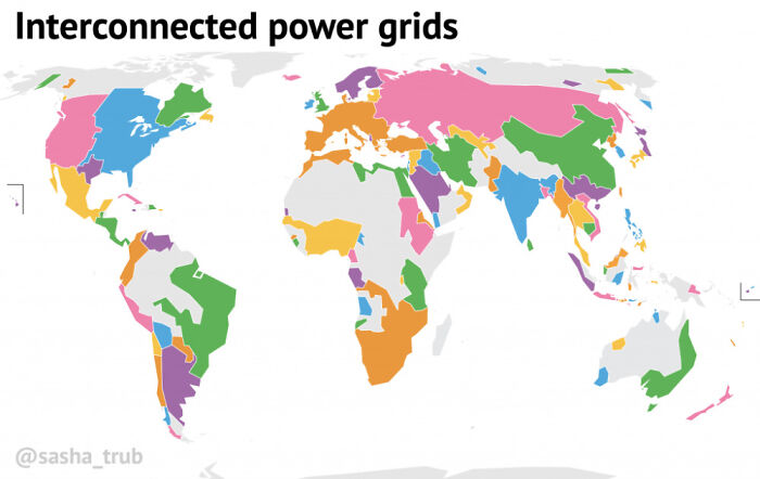
Interconnected Power Grids

Interconnected Power Grids

Grillos Report

Add photo comments
POST
Sum Guy
Community Member
3 years ago DotsCreated by potrace 1.15, written by Peter Selinger 2001-2017

You can see texas there ready to f**k up people's lives again

View more commentsArrow down menu
#86

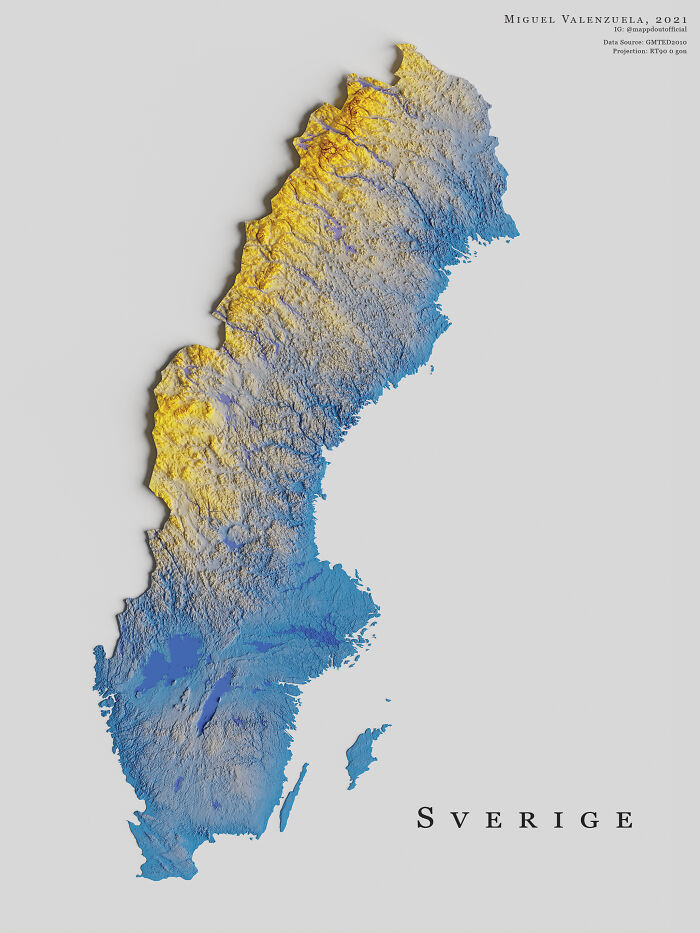
The Topography Of Sweden

The Topography Of Sweden

boytutoy Report

Add photo comments
POST
Gandalf the Pink
Community Member
3 years ago (edited) DotsCreated by potrace 1.15, written by Peter Selinger 2001-2017

Sweden has a bigger surface area than Germany so it's really a giant country (in European standards) but Germany has about 8 times as many people, so Sweden is really, really empty. Because how long it is, driving from south to north is about as long as from Los Angeles to Seattle. That ride would take you from coastlands, through plains and moorlands, decidous forests, mix forests, pine forests, highlands, pine forests, a lot fo pine forests, did I mention pine forests, arctic moorlands, arctic mountain ranges and finally arctic tundra.

View More Replies...
View more commentsArrow down menu
#89

Second Largest Ethnicity In Each European Country

Second Largest Ethnicity In Each European Country

Polaroid1999 Report

Add photo comments
POST
Jos Poisquet
Community Member
3 years ago DotsCreated by potrace 1.15, written by Peter Selinger 2001-2017

Belgium: not correct at all: The largest foreign nationality group are the Dutch. At the beginning of 2020, this involved almost 144,000 people, which corresponds to 23% of the total number of foreigners. This is followed by the Romanians, Poles, Moroccans, Bulgarians, Italians, Spaniards and French. The Turks and Portuguese complete the top 10.

View more commentsArrow down menu
ADVERTISEMENT
See Also on Bored Panda
#91

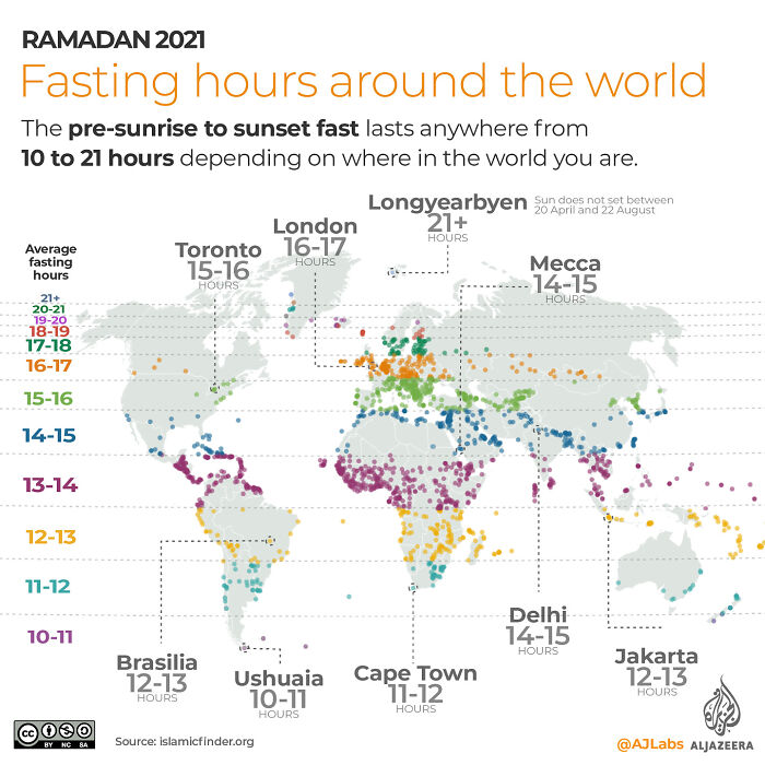
Fasting Hours For Muslims During The Month Of Ramadan

Fasting Hours For Muslims During The Month Of Ramadan

freshlaundrysniffer Report

#92

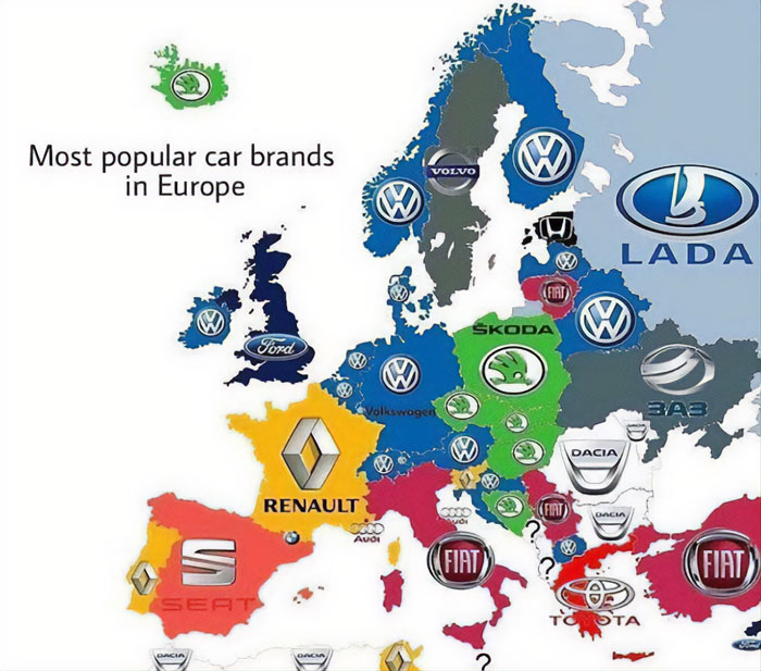
Most Common Car Brand In Each County In Europe

Most Common Car Brand In Each County In Europe

Soapy_boi123 Report

Add photo comments
POST
Sum Guy
Community Member
3 years ago DotsCreated by potrace 1.15, written by Peter Selinger 2001-2017

The UK was like, if we can't make our own brands famous, we are not going to choose any of the European brands

View More Replies...
View more commentsArrow down menu
#93

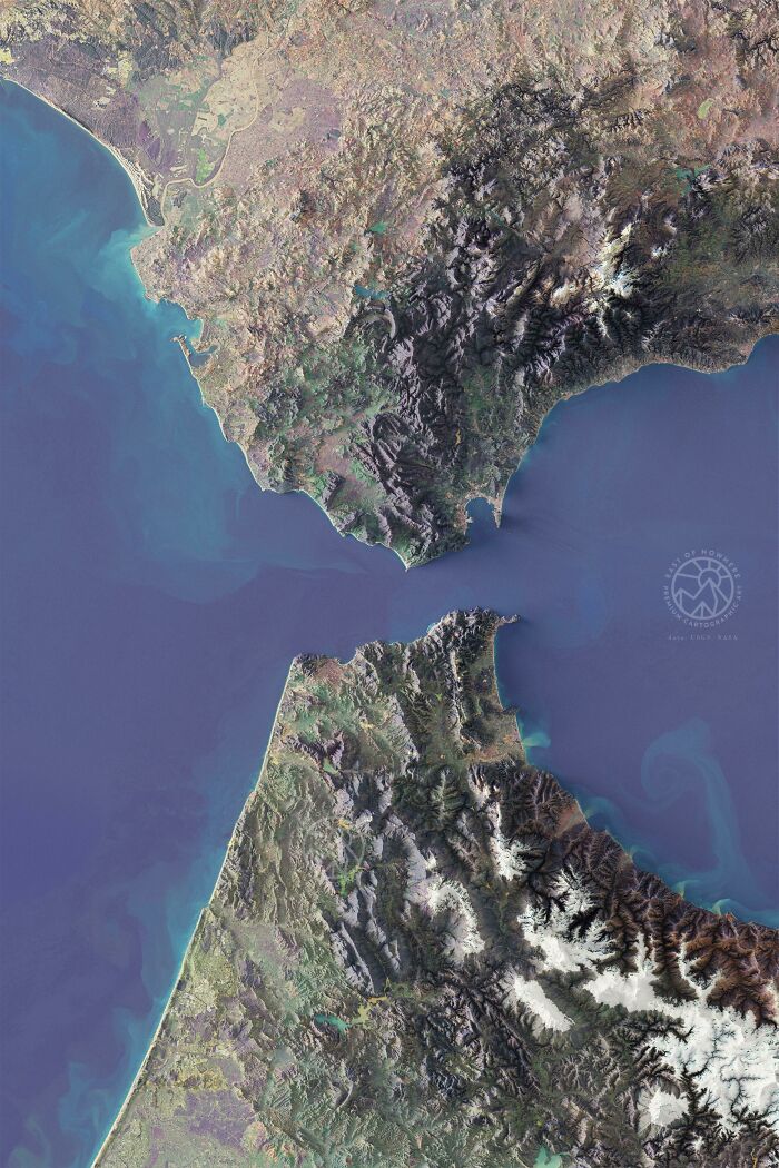
The Strait Of Gibraltar (Stylized Multispectral Imagery)

The Strait Of Gibraltar (Stylized Multispectral Imagery)

eastofnowhereco Report

#94

If 100 People Lived In The UK, Where Would They Live?

If 100 People Lived In The UK, Where Would They Live?

NationalFront_Disco Report

Add photo comments
POST
#95

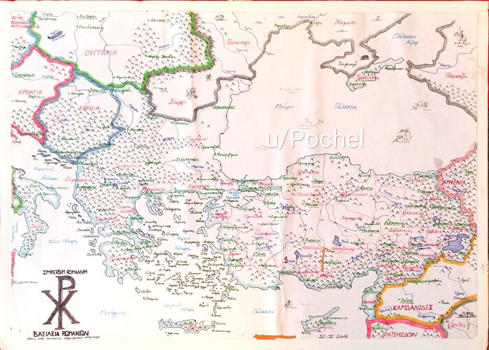
Here's A Hand-Drawn Map Of The Byzantine Empire I Made A Few Years Ago

Here's A Hand-Drawn Map Of The Byzantine Empire I Made A Few Years Ago

Pochel Report

Add photo comments
POST
Shelp
Community Member
3 years ago DotsCreated by potrace 1.15, written by Peter Selinger 2001-2017

OMG that's my map!! I'll swear to God, this is truly surprising (and such a pride!) to see your own work being posted on random corners of the Internet.

View More Replies...
View more commentsArrow down menu
#96

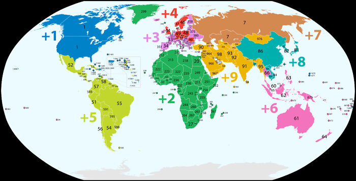
Current Phone Codes Of The World

Current Phone Codes Of The World

katelnitsky Report

ADVERTISEMENT
See Also on Bored Panda
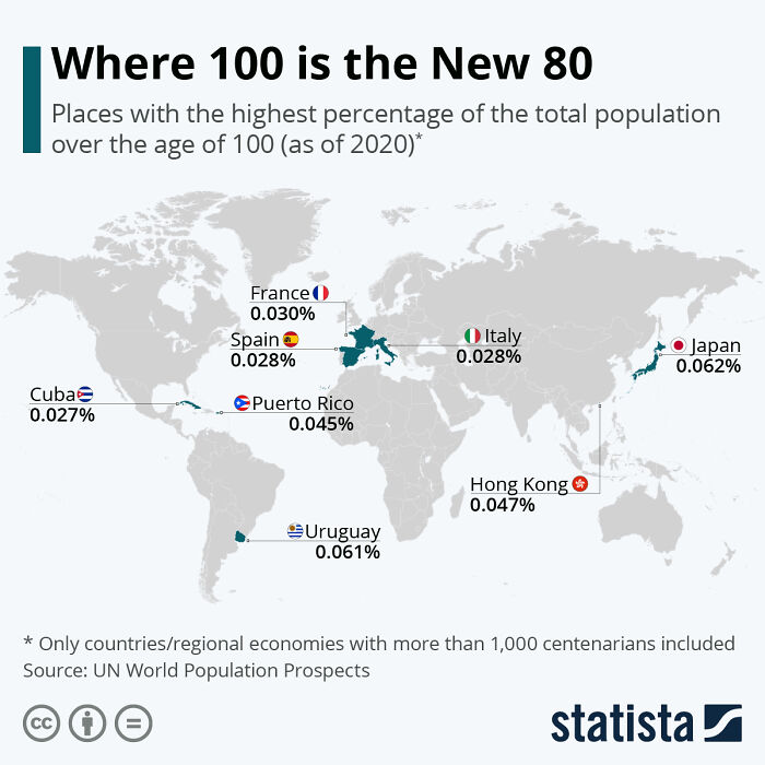
#98

Countries With The Highest Percentage Of Their Total Population Over The Age Of 100

Countries With The Highest Percentage Of Their Total Population Over The Age Of 100

Nordisali Report

Add photo comments
POST
#99

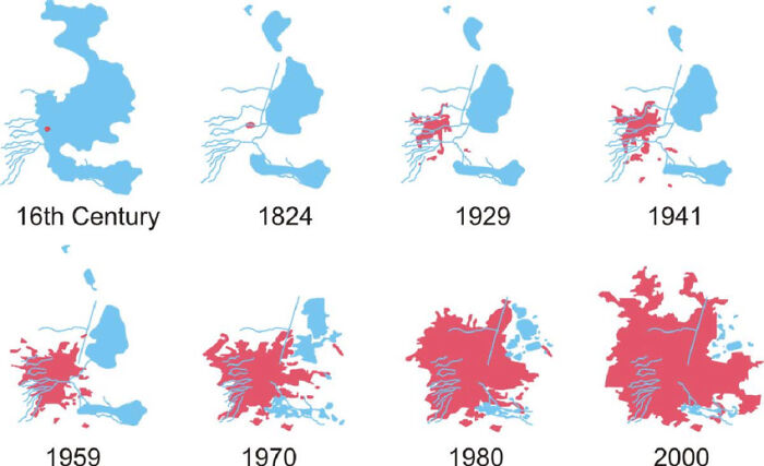
Mexico City Engulfing Lake Texcoco , From 16th Century To 2000

Mexico City Engulfing Lake Texcoco , From 16th Century To 2000

hconfiance Report

Add photo comments
POST
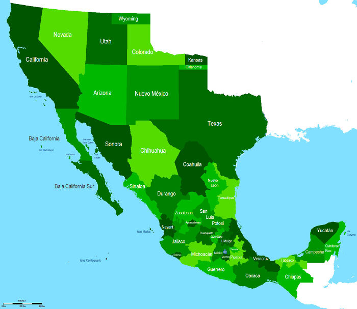
#100

41-State Mexico (If It Recovers Its Former Territories)

41-State Mexico (If It Recovers Its Former Territories)

Cautious_Door2670 Report

Add photo comments
POST
Dave P
Community Member
3 years ago DotsCreated by potrace 1.15, written by Peter Selinger 2001-2017

"recover", Mexico got them by way of conquest not that many years before the US won it in a war from Mexico that Mexico started. And Texas was the Whites and Tejano's (the Natives to Mexico) who joined in a revolt against Mexico.

View more commentsArrow down menu
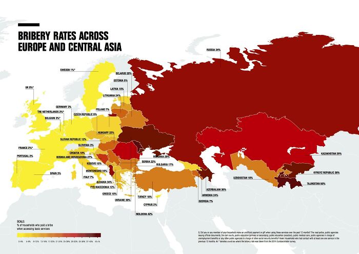
#101

% Of Households Who Paid A Bribe When Accessing Basic Services - Transparency International

% Of Households Who Paid A Bribe When Accessing Basic Services - Transparency International

avp1982 Report

#102

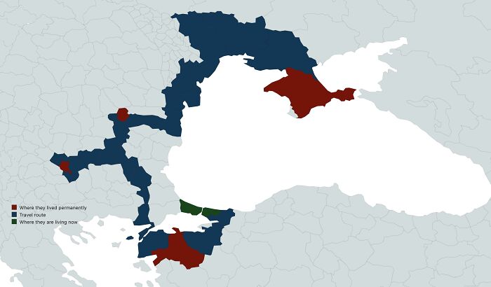
A Map Of My Family’s Escape Route From Crimean Tatar Genocide And Where They Lived

A Map Of My Family’s Escape Route From Crimean Tatar Genocide And Where They Lived

flataleks Report

Add photo comments
POST
#103

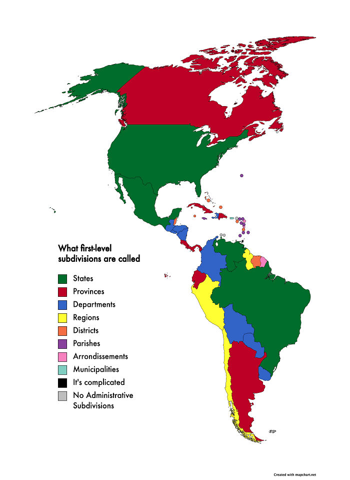
What Countries In The Americas Call Their Main First-Level Subdivisions

What Countries In The Americas Call Their Main First-Level Subdivisions

RoyalFlushAKQJ10 Report

Add photo comments
POST
#104

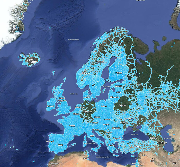
A Map Of Google Street View Accessibility Across Europe

A Map Of Google Street View Accessibility Across Europe

Wlaths Report

#105

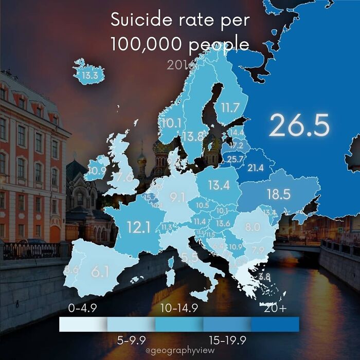
Suicide Rate Per 100,000 People

Suicide Rate Per 100,000 People

GeographyView Report

ADVERTISEMENT
See Also on Bored Panda
#106

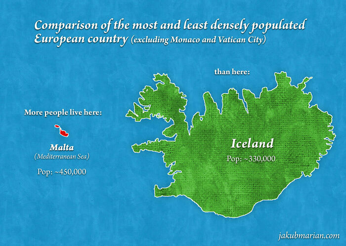
Malta vs. Iceland

Malta vs. Iceland

loliplip Report

Add photo comments
POST
Marika Miettinen
Community Member
3 years ago DotsCreated by potrace 1.15, written by Peter Selinger 2001-2017

Malta is so weird. Half the size of my hometown and the population difference is so huge. We only have around 14k people living here. Sure, I've lived in bigger cities too, but it's just hard to imagine so many people in such a small area :D

View More Replies...
View more commentsArrow down menu
#107

Newer Italian Id Cards Have A Tiny Holographic Relief Map Of Italy

Newer Italian Id Cards Have A Tiny Holographic Relief Map Of Italy

Dedekind19 Report

Add photo comments
POST
#108

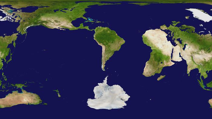
A World Map Centered On Argentina

A World Map Centered On Argentina

CDS_Virtual_Effects Report

#109

The World Split Into 10,000 Equally Populated Regions

The World Split Into 10,000 Equally Populated Regions

Machetegun Report

#110

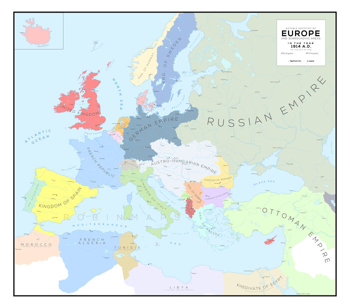
Europe In 1914, Just Before Ww1 Began

Europe In 1914, Just Before Ww1 Began

opxise5 Report

Add photo comments
POST
#111

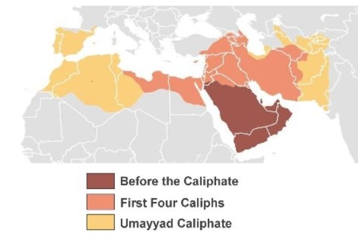
Early Islamic Expansion

Early Islamic Expansion

omar_hafez1508 Report

Add photo comments
POST
Eva Bryson
Community Member
3 years ago

This comment is hidden. Click here to view.

If that's all they want, with the exception of Spain and Portugal, I say "Let them have it"!

View more commentsArrow down menu
#112

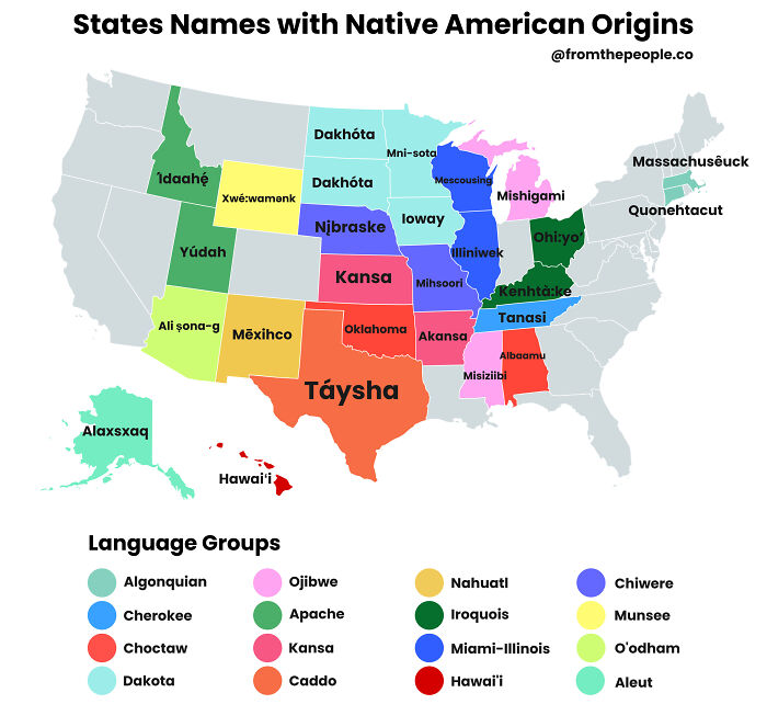
The Majority Of State Names Have Native American Origins

The Majority Of State Names Have Native American Origins

FromThePeopleCo Report

#113

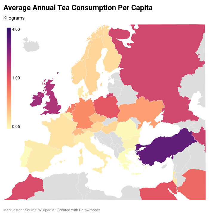
Annual Tea Consumption

Annual Tea Consumption

jestorhastaken Report

ADVERTISEMENT
See Also on Bored Panda
#114

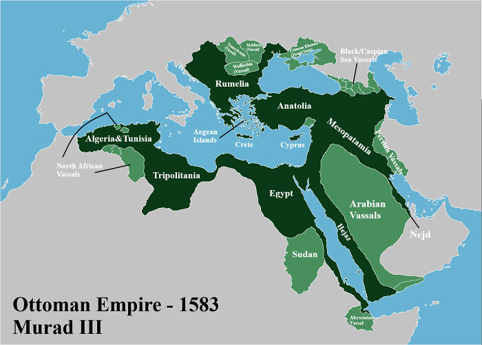
Ottoman Empire 1587 - Murad III (Labeled)

Ottoman Empire 1587 - Murad III (Labeled)

MidEastOfficial Report

Add photo comments
POST
#115

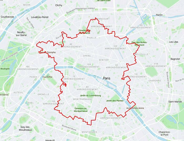
Tour De France Without Leaving Paris

Tour De France Without Leaving Paris

Petrarch1603 Report

Add photo comments
POST
#116

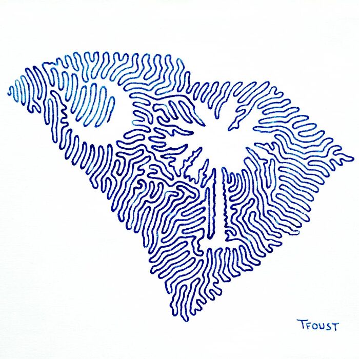
I Intend To Draw All States And Regions With One Line And I Recently Finished South Carolina

I Intend To Draw All States And Regions With One Line And I Recently Finished South Carolina

tfoust10 Report

Add photo comments
POST
Lady Artemis
Community Member
3 years ago DotsCreated by potrace 1.15, written by Peter Selinger 2001-2017

I may have permanently damaged my eyes searching for the start and end points.

View More Replies...
View more commentsArrow down menu
#117

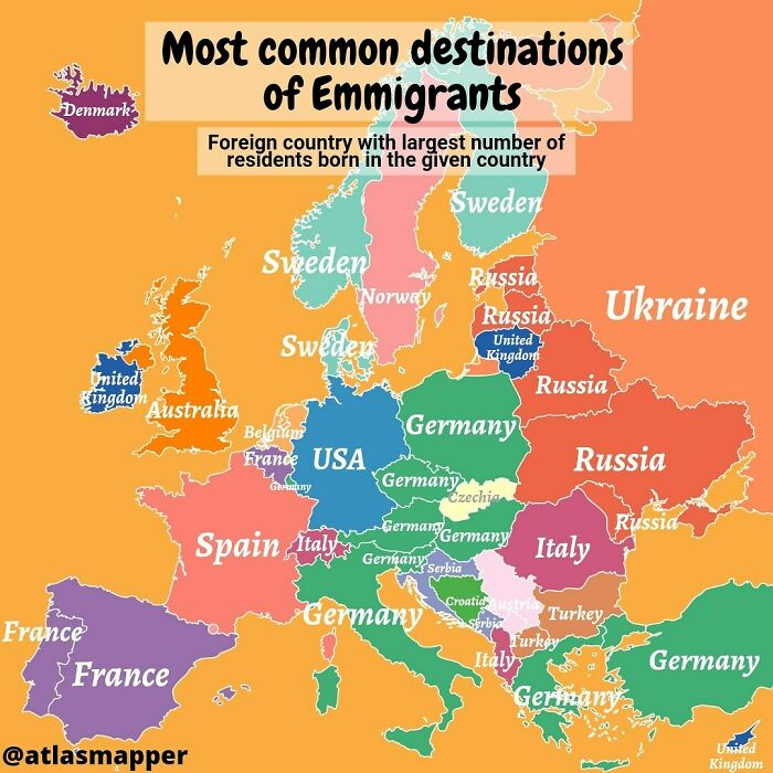
Most Common Destination Of Emigrants In Europe

Most Common Destination Of Emigrants In Europe

atlasmapper Report

#118

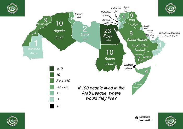
If 100 People Lived In The Arab League, Where Would They Live?

If 100 People Lived In The Arab League, Where Would They Live?

NationalFront_Disco Report

#119

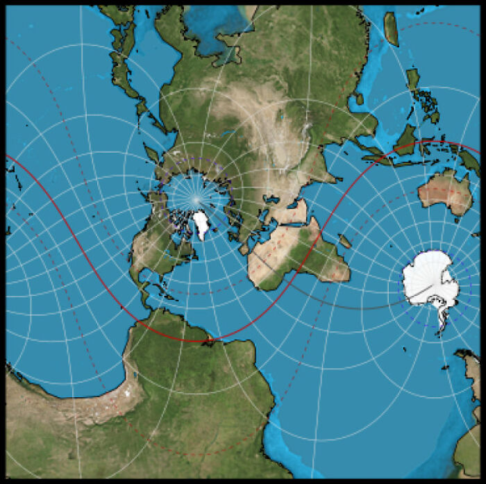
Here I Present To You The Worst Map Projection Ever: The Hotine Oblique Projection

Here I Present To You The Worst Map Projection Ever: The Hotine Oblique Projection

Pablo_BW Report

#120

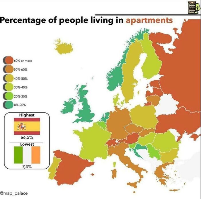
Percentage Of People Living In Apartments In Europe

Percentage Of People Living In Apartments In Europe

UNC-Patriot Report

#121

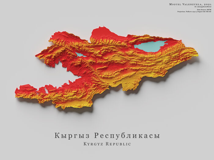
The Topography Of Kyrgyzstan

The Topography Of Kyrgyzstan

boytutoy Report

Add photo comments
POST
ADVERTISEMENT
See Also on Bored Panda
#122

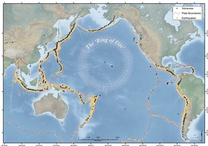
The Pacific 'Ring Of Fire'

The Pacific 'Ring Of Fire'

oglach Report

Add photo comments
POST
Miss Cris
Community Member
3 years ago (edited) DotsCreated by potrace 1.15, written by Peter Selinger 2001-2017

This "ring" is not the drawed circle but all those black spots and yellow areas. It's the border of a tectonic place and its name is due to so many active volcanos are present. Earthquakes, too, by the way.

View more commentsArrow down menu
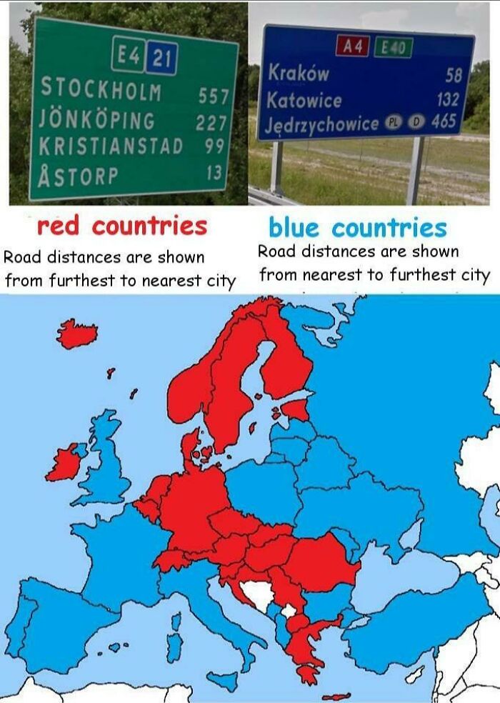
#123

Road Distances Order In Europe

Road Distances Order In Europe

ReinerBraunIsADILF Report

Add photo comments
POST
King Joffrey
Community Member
3 years ago DotsCreated by potrace 1.15, written by Peter Selinger 2001-2017

I didn't realise this was the case but nearest to furthest makes a lot more sense to me...

View more commentsArrow down menu
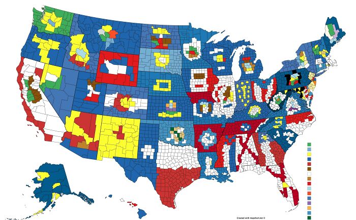
#124

The Flags Of Every U.S. State Made Out Of Their County Lines

The Flags Of Every U.S. State Made Out Of Their County Lines

Orthodoxghee966 Report

Add photo comments
POST
Kinslee Hager
Community Member
3 years ago (edited) DotsCreated by potrace 1.15, written by Peter Selinger 2001-2017

OOF my states(south carolina) looks almost nothing as the flag lol the tree

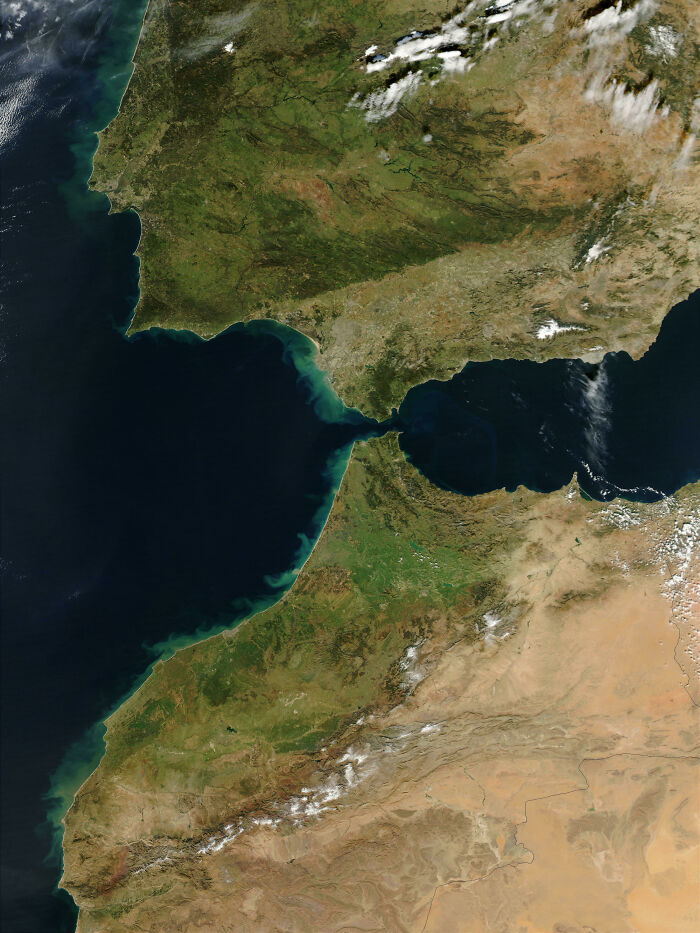
#125

Morocco And The South Of Iberian Peninsula By Nasa

Morocco And The South Of Iberian Peninsula By Nasa

Aelhas Report

Add photo comments
POST
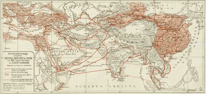
#126

The Trade Routes Between China, India And Rome Around Year 100

The Trade Routes Between China, India And Rome Around Year 100

SteO153 Report

Add photo comments
POST
#127

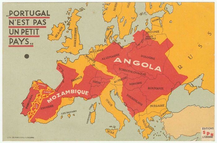
A French Map Showing Europe Compared To The Colonies Of Portugal

A French Map Showing Europe Compared To The Colonies Of Portugal

Tauralandia Report

Add photo comments
POST
Shelp
Community Member
3 years ago DotsCreated by potrace 1.15, written by Peter Selinger 2001-2017

This is not a French map, this is a Portuguese map printed in Lisbon and meant to serve as a mean of propaganda for the Estado Novo dictatorship. The map exists in French and in English and this appears to be the French version. It has some flaws (Lithuania being labelled as East Prussia, for example) and the French is not perfect. And, of course, this is propaganda.

#128

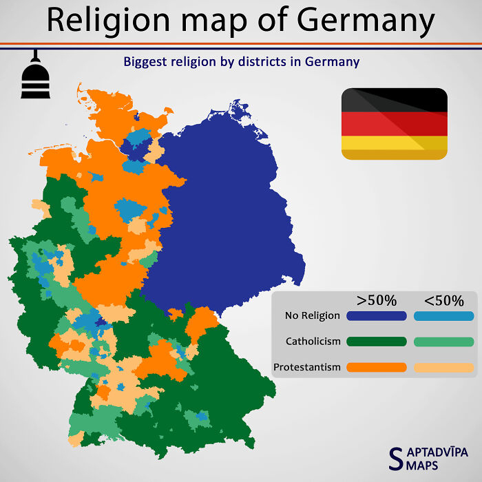
Religion Map Of Germany

Religion Map Of Germany

Saptadvipamaps Report

Add photo comments
POST
Shelp
Community Member
3 years ago DotsCreated by potrace 1.15, written by Peter Selinger 2001-2017

Where you can perfectly see the East/West German border

#129

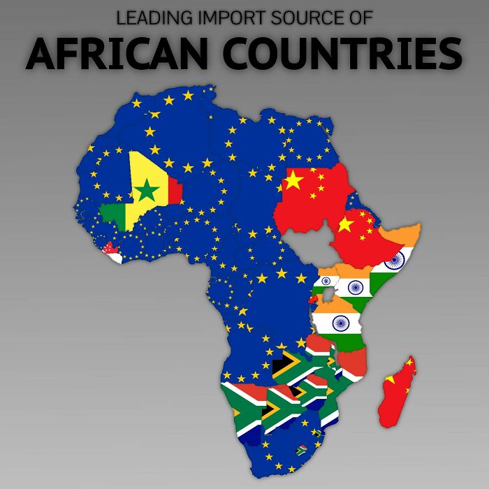
Leading Import Source Of Africa

Leading Import Source Of Africa

mapsgrey Report

Add photo comments
POST
Radek Suski
Community Member
3 years ago DotsCreated by potrace 1.15, written by Peter Selinger 2001-2017

We stole everything from them first, screwed entire countries and now we are selling them subventioned products and screwing their economies

View More Replies...
View more commentsArrow down menu
ADVERTISEMENT
See Also on Bored Panda
#130

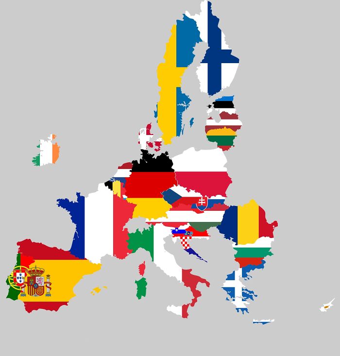
2020 European Union Flag Map

2020 European Union Flag Map

Arthur_Sebastian_703 Report

Add photo comments
POST
#131

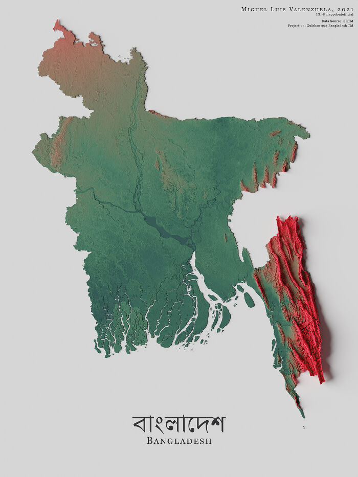
The Topography Of Bangladesh

The Topography Of Bangladesh

boytutoy Report

Add photo comments
POST
#132

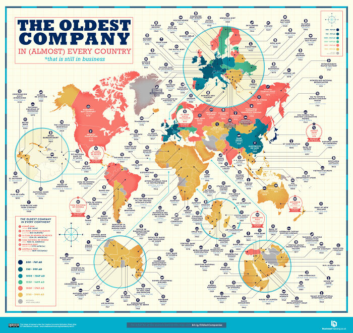
Oldest Companies Around The World That Are Still In Business

Oldest Companies Around The World That Are Still In Business

PapaJoke64 Report

Add photo comments
POST
Sum Guy
Community Member
3 years ago DotsCreated by potrace 1.15, written by Peter Selinger 2001-2017

Well, this one is useless because you can't read it even if you download and zoom in

View More Replies...
View more commentsArrow down menu
#133

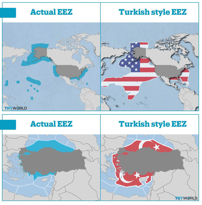
Actual Eez vs. Turkish Style Eez — Case Study: If Applied The Turkish Logic, The Eez (Exclusive Economic Zone) Of The USA Would Include Large Areas Of The Pacific Ocean, Contrary To International Law

Actual Eez vs. Turkish Style Eez — Case Study: If Applied The Turkish Logic, The Eez (Exclusive Economic Zone) Of The USA Would Include Large Areas Of The Pacific Ocean, Contrary To International Law

craoft Report

Add photo comments
POST
Shelp
Community Member
3 years ago DotsCreated by potrace 1.15, written by Peter Selinger 2001-2017

That's a great visualisation to understand what's currently going on in the region

#134

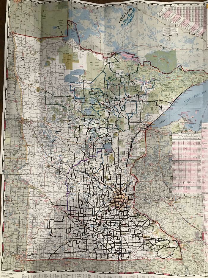
My Covid Project: Travel As Many Roads As I Can In Minnesota

My Covid Project: Travel As Many Roads As I Can In Minnesota

sod_dos Report

#135

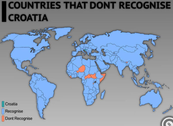
Countries That Dont Recognize Croatia

Countries That Dont Recognize Croatia

neueszukunft00 Report

Add photo comments
POST
Shelp
Community Member
3 years ago DotsCreated by potrace 1.15, written by Peter Selinger 2001-2017

They don't really "don't recognise" Croatia, they just have no diplomatic relationships with it. Bhutan for example only has a couple of embassies across the world, which doesn't mean that they don't recognise every other country they don't have an ambassador in.

View More Replies...
View more commentsArrow down menu
#136

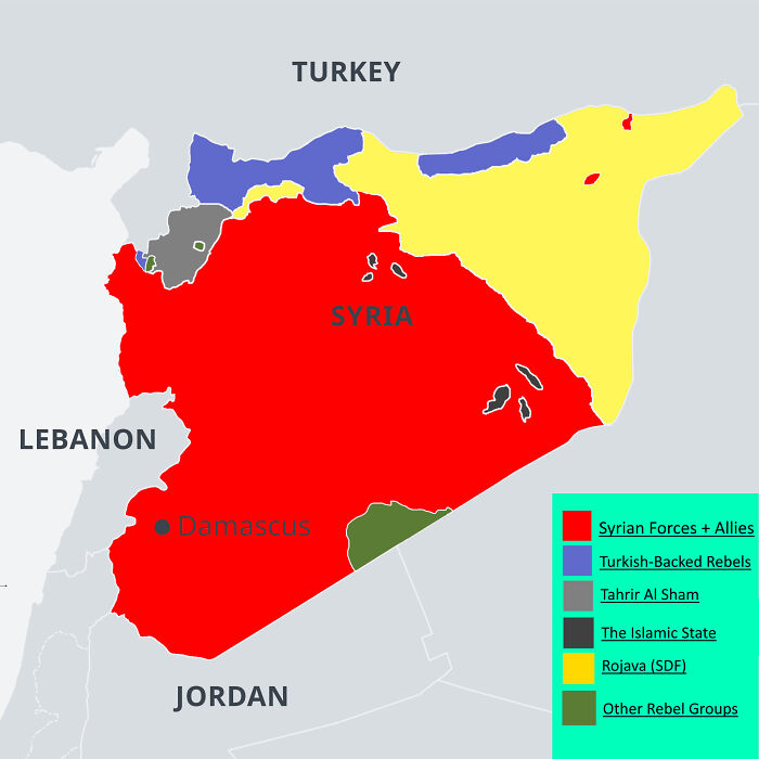
Syrian Civil War Map, February 2021

Syrian Civil War Map, February 2021

KhitanMaps Report

Add photo comments
POST
#137

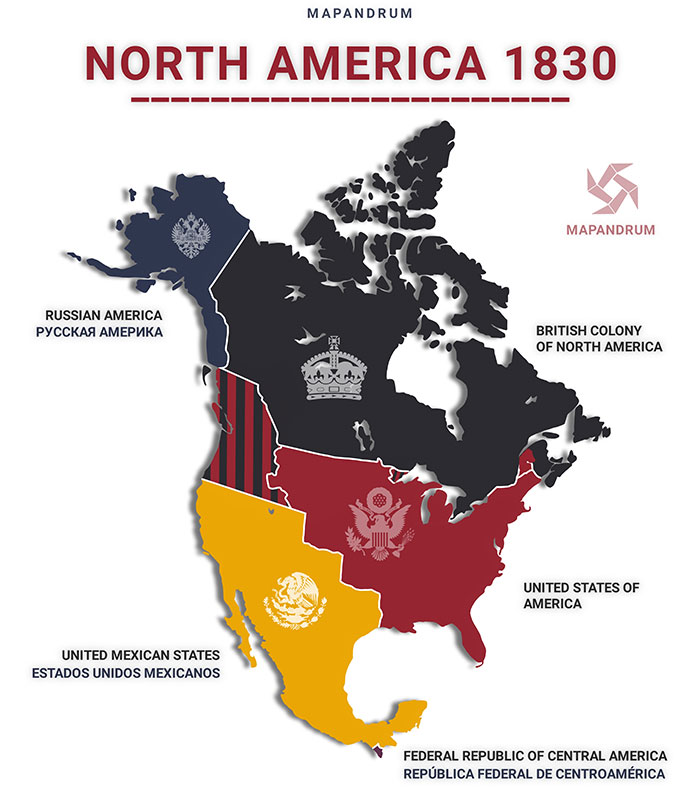
North America In 1830

North America In 1830

DrunkPropagandist Report

Add photo comments
POST
Shelp
Community Member
3 years ago DotsCreated by potrace 1.15, written by Peter Selinger 2001-2017

For those wondering, the Federal Republic of Central America covered most of current Central America, but the map decided to cut directly under Mexico, for some weird reason

View More Replies...
View more commentsArrow down menu
ADVERTISEMENT
See Also on Bored Panda
#138

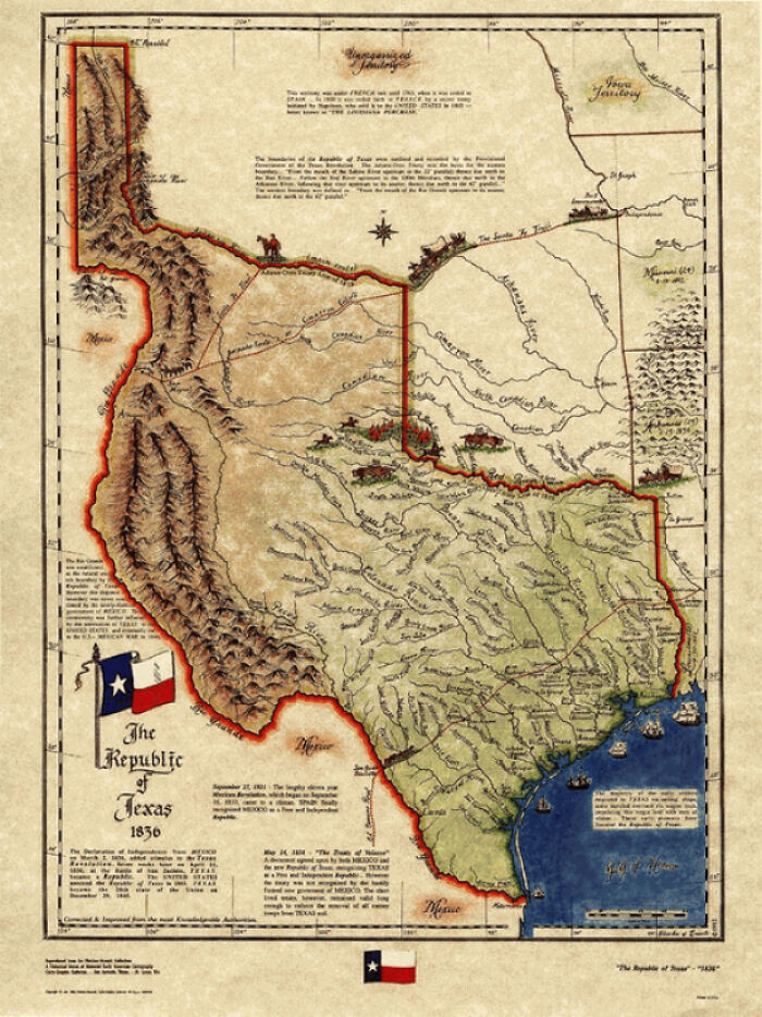
The Republic Of Texas, A Real Country That Lasted 10 Years

The Republic Of Texas, A Real Country That Lasted 10 Years

cheeseface35 Report

#139

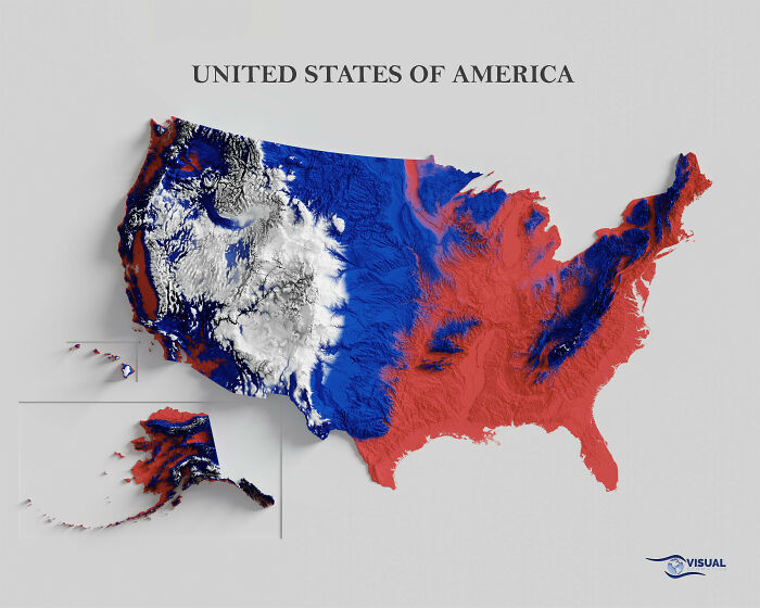
USA Shaded Relief Map

USA Shaded Relief Map

czn9001 Report

Add photo comments
POST
#140

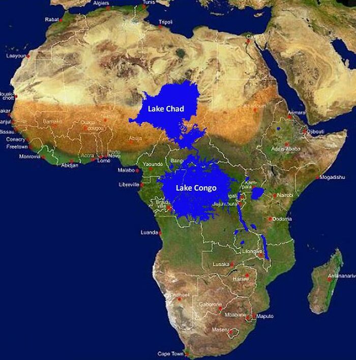
What Would Happen If The Mouth Of The Congo River Were Dammed

What Would Happen If The Mouth Of The Congo River Were Dammed

kernals12 Report

Add photo comments
POST
#141

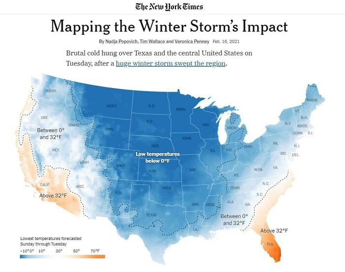
Mapping The Winter Storm’s Impact: Nytimes

Mapping The Winter Storm’s Impact: Nytimes

rosswi88 Report

Add photo comments
POST
#142

Most Googled Countries By Us State (Except The Us Itself)

Most Googled Countries By Us State (Except The Us Itself)

GergoliShellos Report

#143

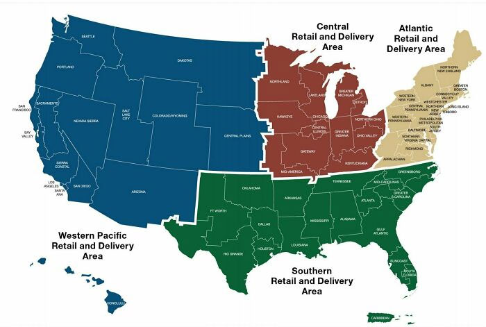
The 2021 USPS Delivery Regions

The 2021 USPS Delivery Regions

IcallOutTheBS Report

Add photo comments
POST
#144

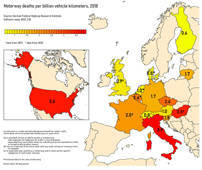
Motorway Deaths Per Billion Vehicle Kilometers, 2018

Motorway Deaths Per Billion Vehicle Kilometers, 2018

Proxima55 Report

#145

American Territorial Acquisitions Sorted By President

American Territorial Acquisitions Sorted By President

Motherdragon64 Report

Add photo comments
POST
ADVERTISEMENT
#146

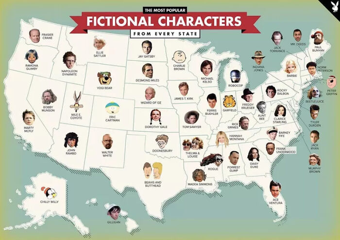
Where Fictional Characters Are From In The U.S.

Where Fictional Characters Are From In The U.S.

World-Tight Report

#147

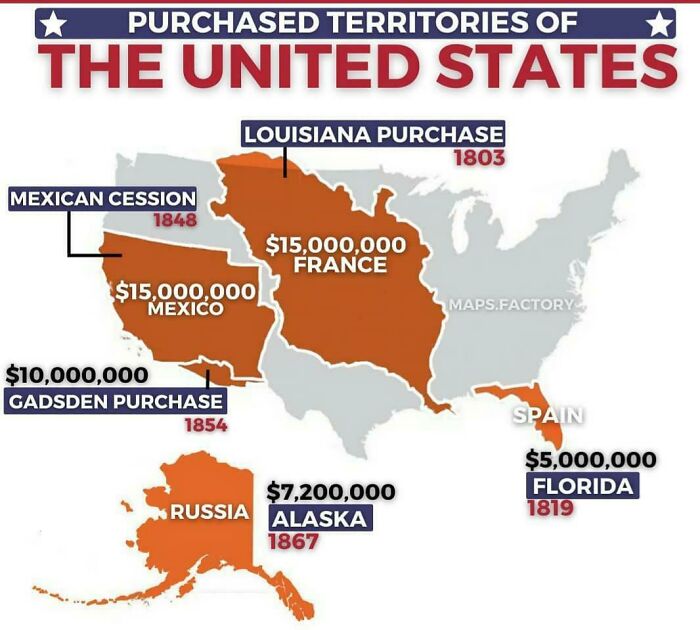
Purchased Territories Of The United States

Purchased Territories Of The United States

pastelitooo Report

#148

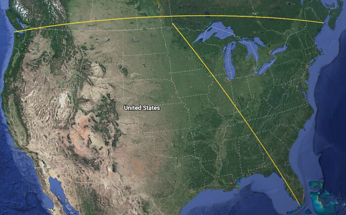
If You Draw "Straight" Lines Between The Northern And Southern Most Points In The Contiguous Us Along With The Eastern And Western Most Points The Two Lines Never Intersect

If You Draw "Straight" Lines Between The Northern And Southern Most Points In The Contiguous Us Along With The Eastern And Western Most Points The Two Lines Never Intersect

DarkerThanAzure Report

#149

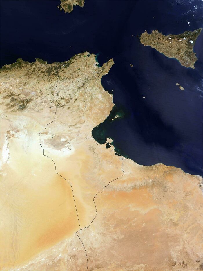
High Resolution Satellite Map Of Tunisia

High Resolution Satellite Map Of Tunisia

Ogso06 Report

Add photo comments
POST
#150

Value Of Private Land In The Contiguous United States

Value Of Private Land In The Contiguous United States

KenFyr Report

Add photo comments
POST
#151

What Do You Call The Night Before Halloween?

What Do You Call The Night Before Halloween?

Coldlymelt Report

#152

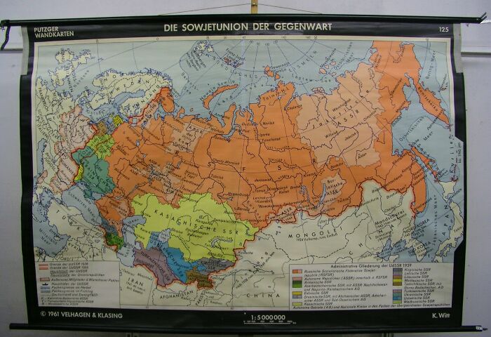
West German School Map Of The Soviet Union (1961)

West German School Map Of The Soviet Union (1961)

adawkin Report

Add photo comments
POST
#153

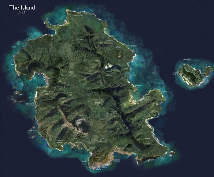
Satelitte Map Of The Island From The TV Show "Lost"

Satelitte Map Of The Island From The TV Show "Lost"

Choekaas Report

Add photo comments
POST
ADVERTISEMENT
#154

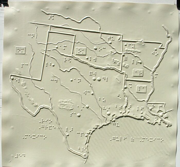
Braille Map Of Southern Us

Braille Map Of Southern Us

tomydenger Report

Add photo comments
POST
#155

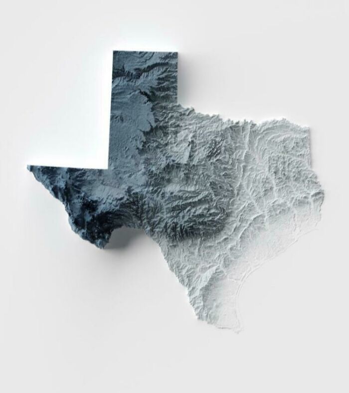
Topography Of Texas

Topography Of Texas

IPetFatTurkeys Report

Add photo comments
POST
#156

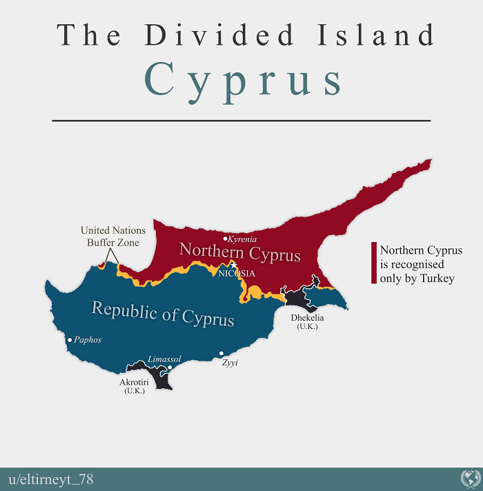
The Cyprus Dispute

The Cyprus Dispute

Eltirneyt_78 Report

Add photo comments
POST
James016
Community Member
3 years ago DotsCreated by potrace 1.15, written by Peter Selinger 2001-2017

My wife was born in Northern Cyprus but came to the UK when she was 11

#157

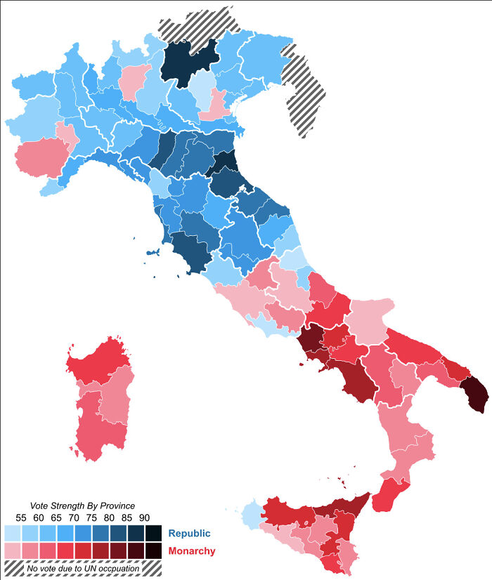
The Italy Referendum On Becoming A Republic Versus A Monarchy

The Italy Referendum On Becoming A Republic Versus A Monarchy

fmwb Report

#158

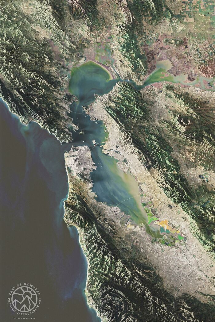
The Bay Area, California (Stylized Multispectral Imagery)

The Bay Area, California (Stylized Multispectral Imagery)

eastofnowhereco Report

Add photo comments
POST
#159

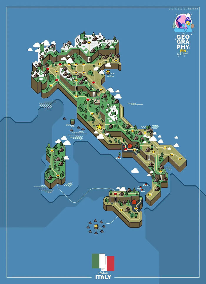
Map Of Italy In The Style Of Mario World

Map Of Italy In The Style Of Mario World

vladgrinch Report

Add photo comments
POST
#160

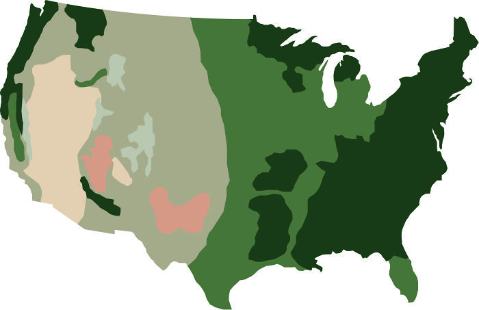
I Made A Minimalist Map Of USA Based On The Colors Of Google Satellite Images

I Made A Minimalist Map Of USA Based On The Colors Of Google Satellite Images

bergluna Report

Add photo comments
POST
#161

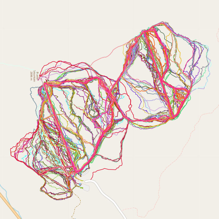
I Tracked Almost Every Day At My Home Ski Resort The Past Couple Years

I Tracked Almost Every Day At My Home Ski Resort The Past Couple Years

dcfam Report

Add photo comments
POST
ADVERTISEMENT