35 Informative And Unusual Maps That Might Change Your Perspective On Things, As Shared On This Online Group (New Pics)
InterviewFor me, maps are the perfect fusion of art, information, insight, and entertainment. They help us navigate both physically and in the realm of ideas. What separates a good map and a great one is that the latter doesn’t stop with just mapping the territory: it expands the borders of our imagination.
There’s hardly a better place to see original, unusual, and interesting maps than this subreddit right here. Though we can’t mention the name (thanks, internet police!), it’s a veritable treasure chamber for cartographers, amateur and professional alike! Having celebrated its 10th birthday this spring, the online group now boasts more than 1.6 million members, pulling in thousands of new ones on a steady basis. Content is king and these redditors, including the founder, land surveyor Patrick McGranaghan, make some truly marvelous maps.
Featured here you’ll find some of the freshest and greatest new maps. Pack your bags, put on your safari hats, and let’s go on an adventure, Pandas! Just remember to upvote the maps that you enjoyed the most, the ones that taught you something new, and the ones that gave you a fresh perspective on the world.
Patrick, the founder of the subreddit, revealed to Bored Panda what makes a good mapmaker and whether we all need to be tip-top artists. A lot depends on the purpose of the map itself, however, the main goal is to make it as informative and easy to understand as possible. Art skills? Not as important. (Though certainly a plus!)
"There are many different reasons one chooses to make a map. Sometimes for navigation, sometimes for showing statistical phenomena, and sometimes for fantasy. While artistic skill helps, it is not absolutely necessary. The important thing is to make it easy for users to glean useful information. Most maps should have a thesis or a story it is going to tell and this needs to be told through the map," he said.
Hungry for more magnificent maps? Then you’ll want to have a scroll through Bored Panda’s previous articles about map-lovers and their creations here: [Unrolls 5 parchments with ancient symbols and drawings] Part 1, Part 2, Part 3, Part 4, and Part 5.
More info: Reddit | Twitter | Tumblr
This post may include affiliate links.
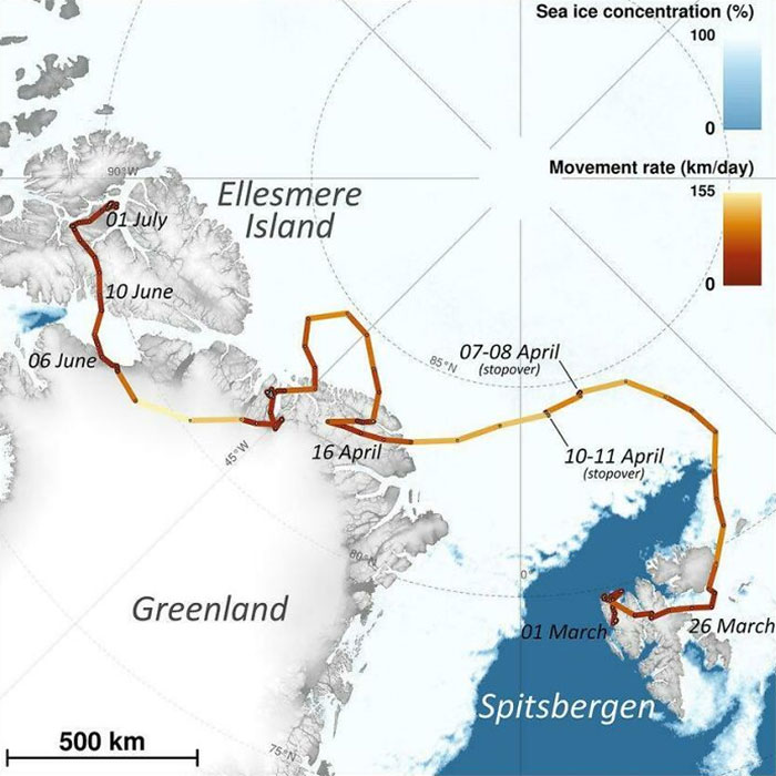
The Journey Of An Arctic Fox Who Walked From Norway To Canada In 2018
I was curious to find out what personal projects Patrick has been working on recently. "Lately, I've been learning Blender. It is more of a 3-D animation program used by video game developers, but I believe that there are ways to use it to display maps," he spoke about the innovative way of using the program.
"You might have seen some beautiful maps by Sean Conway and Scott Reinhard showing old maps with digital elevation terrain underneath. These are often made in Blender. Blender has a great ability to show light and shadow patterns that are almost photo-realistic. I think there are ways to use this program beyond showing maps with realistic terrain. I'm still a novice now, but I'd like to explore other ways this program can visualize maps," Patrick spoke about his ongoing adventure to learn Blender. If you Pandas haven't already, you really ought to take a look at Sean and Scott's work as well.
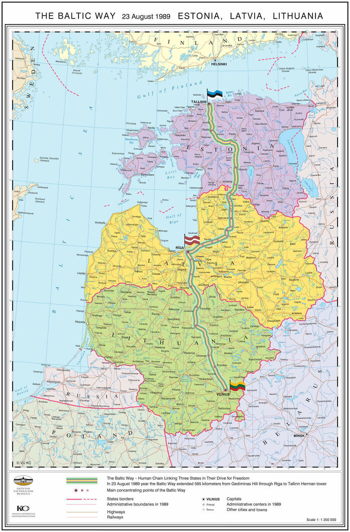
The Baltic Way. On 23 August 1989, Two Million People Joined Their Hands To Form A Human Chain Spanning 675.5 Km Across The Three Baltic States. The Protest Was Against The Soviet Occupation, And To Support The Independence Movements Of The Three States
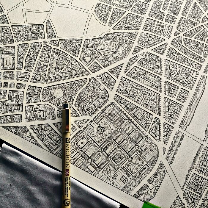
A Map Art Piece I'm Working On Of Paris' Latin Quarter
The founder also told Bored Panda about the current state of the subreddit and how Reddit as a whole has changed recently. Changes in tech are also driving changes in content. "The subreddit is doing well. Reddit overall over the last few years has shifted towards mobile-friendly content. Reddit used to be only for desktop users. In the early days, the content was mostly large files that were wallpaper-sized. They were great for zooming in and exploring in detail."
However, these days are long gone. Nowadays, "Reddit is overwhelmed" with users who only use it on their smartphones and other mobile devices. "For better or worse, that is how it is and that's the trend for the future. The subreddit contains a lot of bite-size Instagram-style statistical maps. The community upvotes this content and if that's what they want, that's the direction the sub will take."
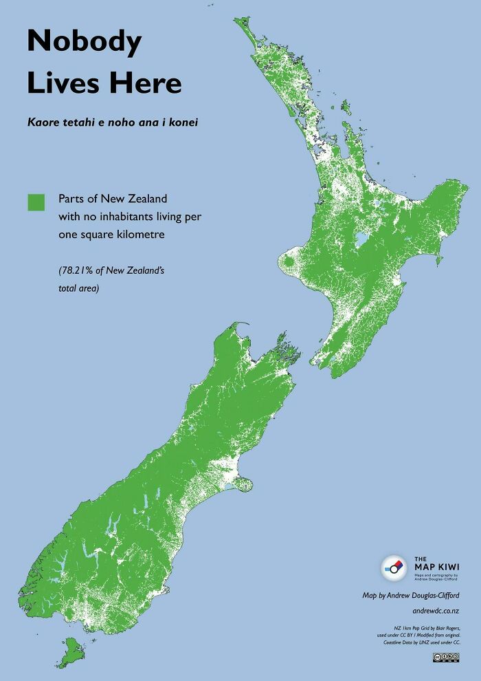
No One Lives In The Green Part Of New Zealand,the Population Density There Is 0 People Per Km And That Is About 78% Of New Zealand Land
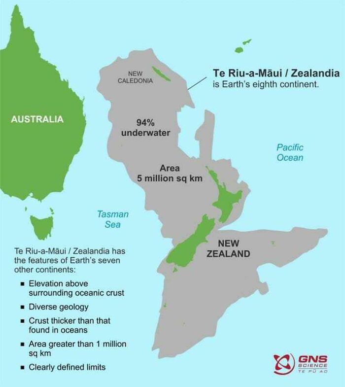
Zealandia, The 8th Continent That's Almost Entirely Submerged
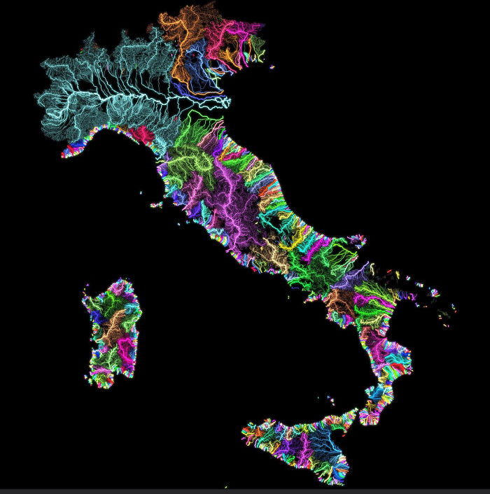
Rivers Of Italy
Patrick, the founder of the subreddit, was kind enough to go into detail about the online group, map-making, and his passion for maps on a number of occasions.
“I've noticed, especially as I've gotten older, that you only have so much time on this planet and every day that is wasted is a day that you'll never get back. If you want to get out and explore the world you just have to do it,” Patrick previously told Bored Panda about seizing the day and starting your adventure today, instead of putting these things off indefinitely.
“Some adventures will cost time and resources, but the real question I ask myself is can I afford not to do some goal I have my heart set on. There are so many opportunities in this world that it may be hard to choose, but if you wait too long those opportunities will be gone forever," Patrick said that we have to seize opportunities to live (really live) as they come.
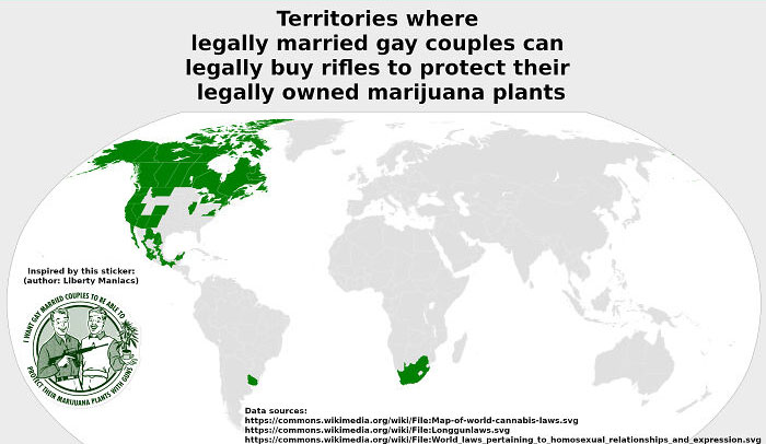
Territories Where Married Gay Couples Can Buy Rifles To Protect Their Marijuana Plants
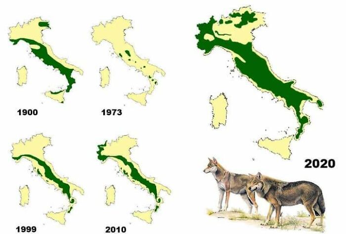
Wolf Distribution In Italy Since 1900
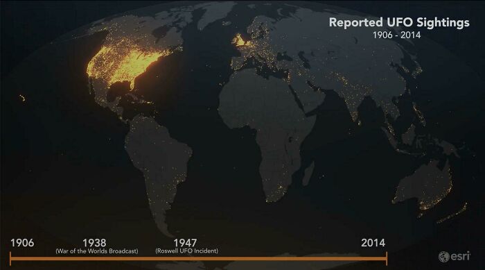
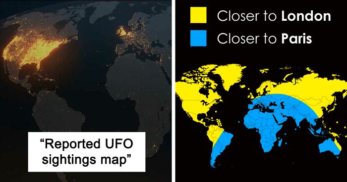
Reported UFO Sightings Map. Last 115 Years
UFO means unidentified flying object. It does not mean alien most are probably military from earth.
Recently Patrick had been working on pixel maps that are bound to get the attention of anyone who’s got a penchant for video games, retro items, or pixel art. "This spring, I was making a lot of pixel maps that looked like old video game graphics. I picked some exotic places like Botswana and Mongolia to make these maps," he revealed a bit about his projects.
"I think a great way to learn about an exotic place is to make a map of it and really give some hours and care into making the map look as good as possible. You really get a connection for a place as you're putting labels on and making decisions about what to include and where to lay everything out,” the founder told Bored Panda.
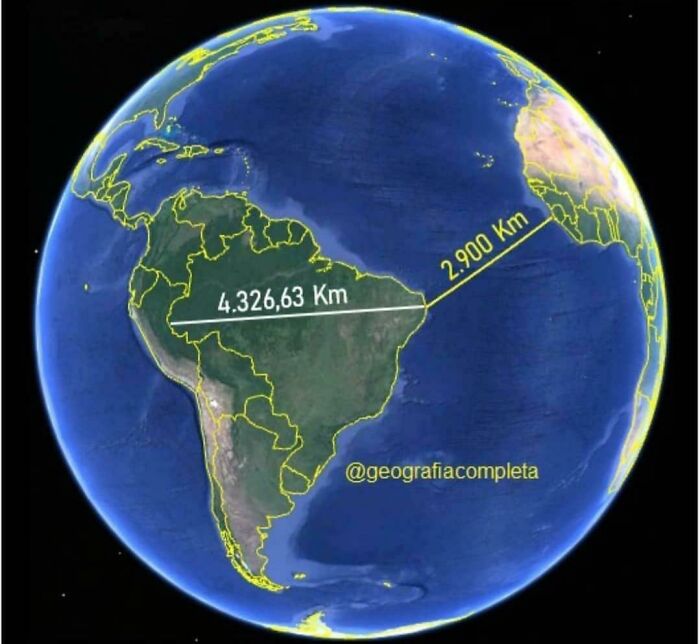
The Easternmost Point Of Brazil Is Closer To Africa Than To Its Westernmost Point
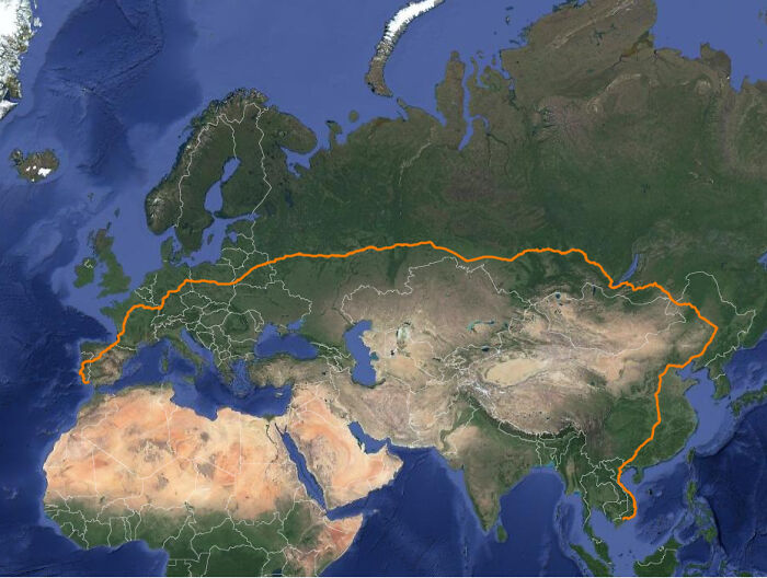
The Longest Possible Train Travel In The World
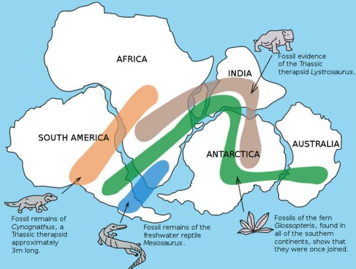
Existence Of Pangaea Proven With Evidence Of Similar Fossils Across Continents
As a child I always thought this was easy to prove by just looking at a world map, the countries separated by oceans all fit together like jigsaw pieces.
According to Patrick, moderating the subreddit is all about keeping a delicate balance and staying realistic: the fact is that you can’t keep everyone happy all the time. Nor should you try to when questions of quality are involved. “Moderating is always a delicate balance. It is impossible to please everybody. If you are too laissez-faire you get a lot of low effort and ugly submissions and the users complain,” he said.
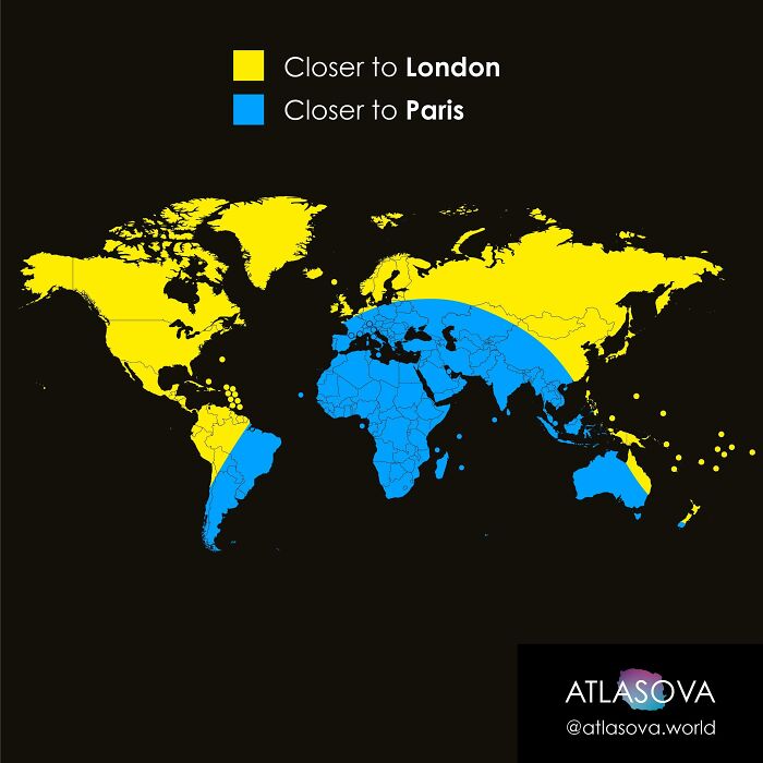
Closer To Paris Or To London?
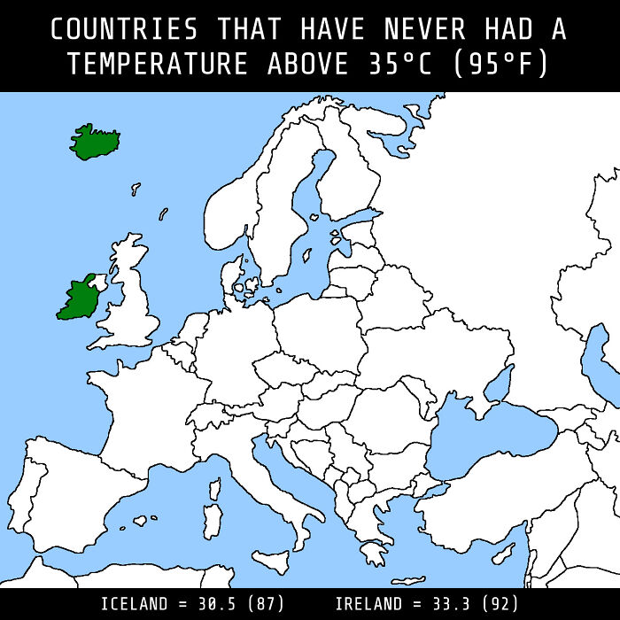
Countries That Have Yet To See True Temperature Extremes
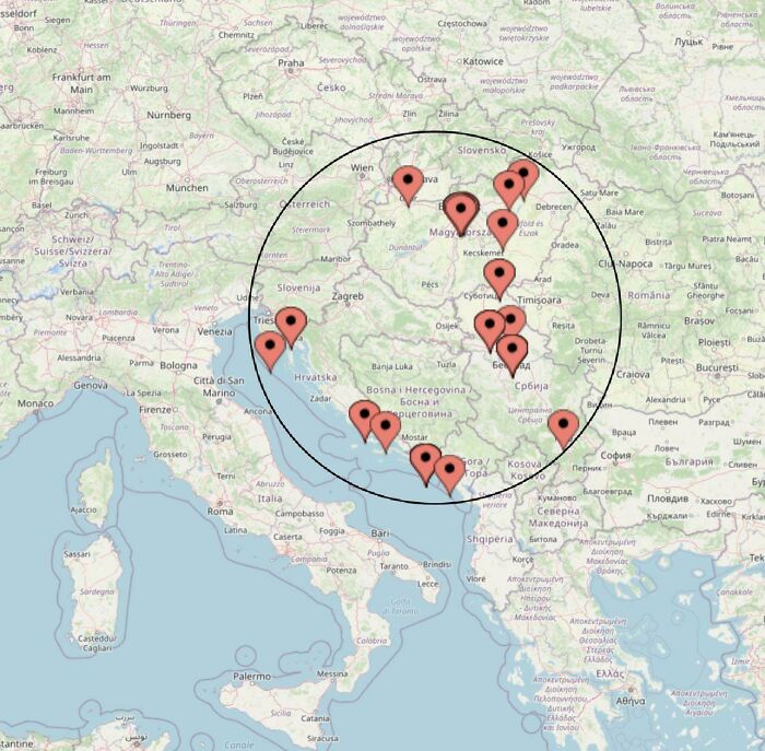
After Tokyo 2020 This Map Remains The Same. All Men’s Water Polo Gold Medal Winners Since 2000 Were Born Inside This Circle
However, being too strict is also not an option. “If you are too strict, then you risk alienating those who supply the content for the sub. I try to find a balance between these two extremes. Overall, I'm satisfied with the moderating and I don't foresee any changes in the immediate future," Patrick explained.
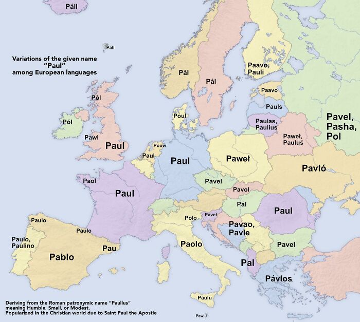
Variations Of The Given Name “Paul”
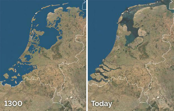
Land Reclamation In The Netherlands
During low tide, you can walk from the mainland to the islands in the North as our country is flat as a pancake :)
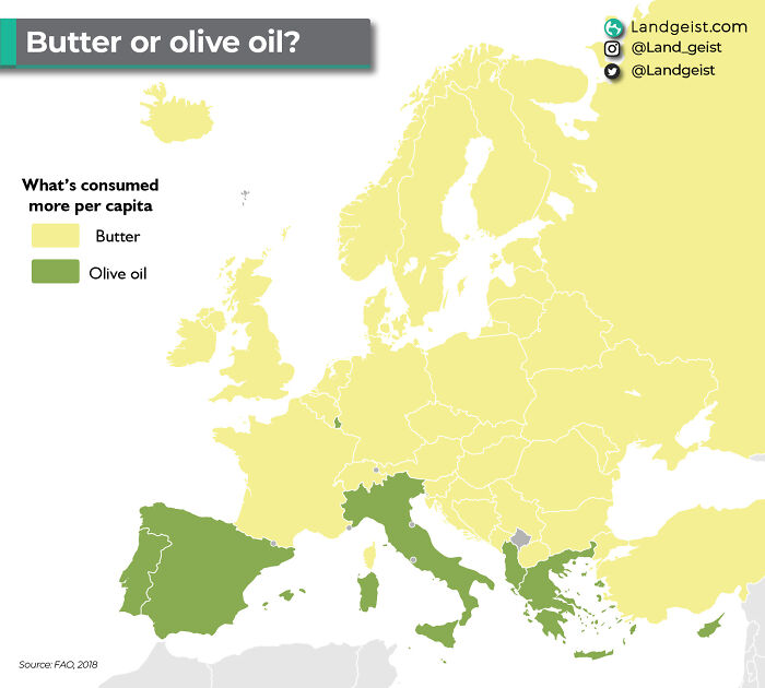
Butter Or Olive Oil? Based On Actual Per Capita Consumption
Some people are naturally more skilled at navigation and using maps than others. Though, of course, navigation is a skill and you can get better at it so long as you’re patient, dedicated, and spend enough time honing it. “The older I get, the more I realize that spatial awareness just comes naturally to some people, and for others, it's a struggle," Patrick said. “In a way, reliance on Google Maps has made us dumber. We let the navigation app do all the work for us and don't engage with making the decisions.”
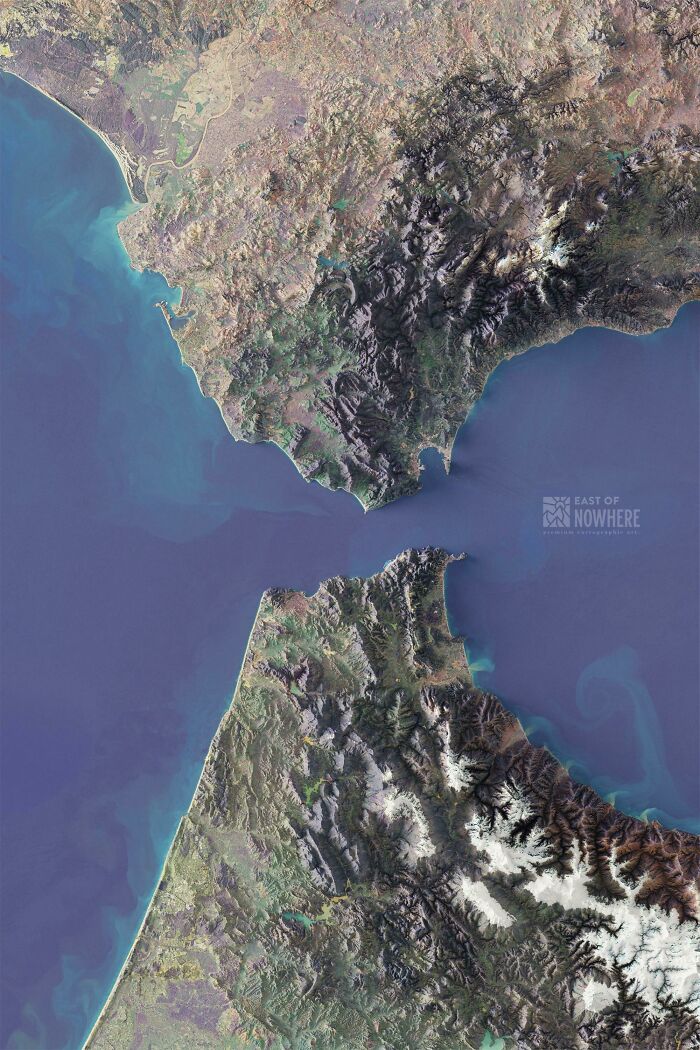
The Strait Of Gibraltar
Europe If The Sea Level Rose 100m
Eh, the Dutch would survive. We'd just build a giant dome over the Netherlands and continue on as if nothing happened
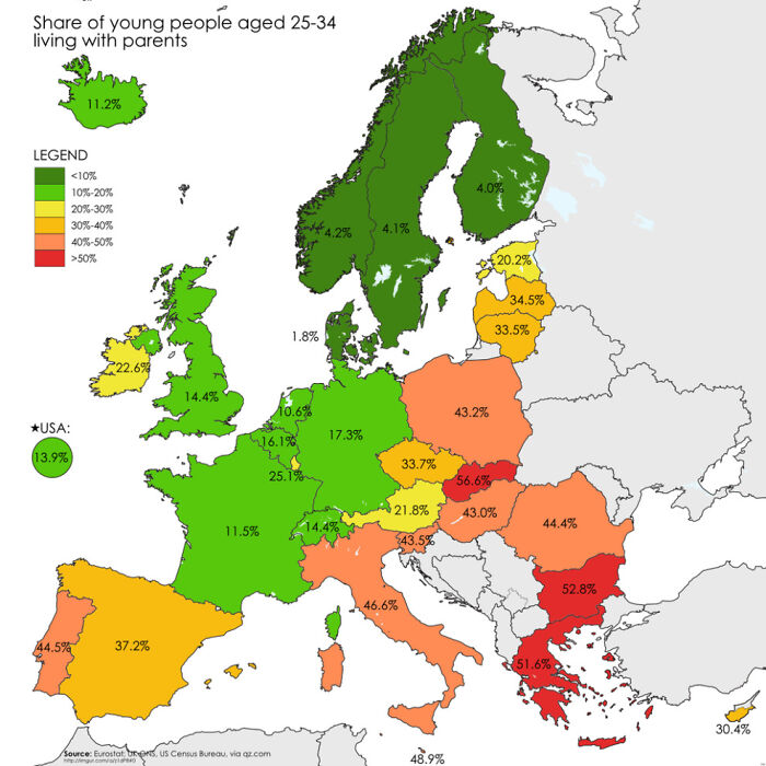
Share Of Young People Aged 25 -34 Living With Parents
The founder had some advice for everyone about how we can develop our navigation skills in our local area. It’s a great way to get your foot in the door before moving on to bigger adventures.
"If you live in a place with a tall hill or some viewpoint, go up there some time and look around. Try to identify as many landmarks as you can. Notice where they are in relation to each other. Look for new landmarks that you've never noticed before and keep them in mind as you navigate your hometown.”
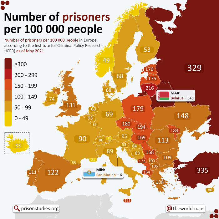
Number Of Prisoners Per 100 000 People In European Countries
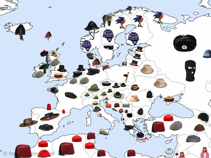
Traditional Hats Of Europe
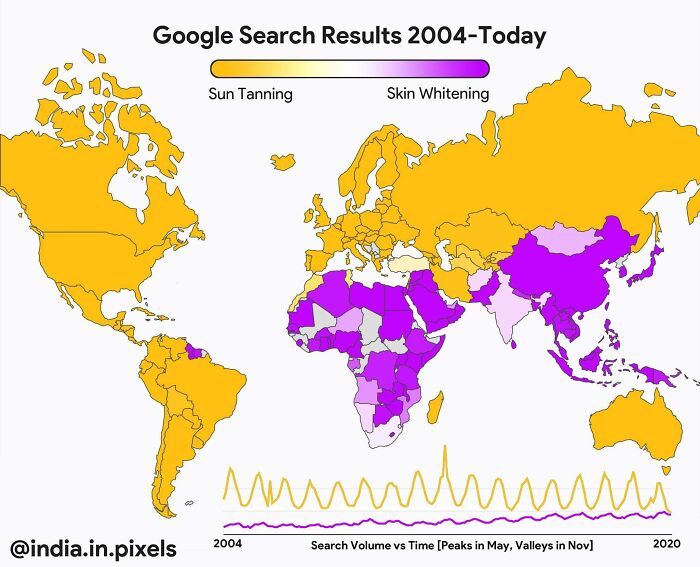
Sun Tanning vs. Skin Whitening
Patrick continued: “If there are rivers or other features that cause chokepoints on bridges or highways, memorize all the bridges and where they go. In this way, you'll know the layout of your city and how to get around.”
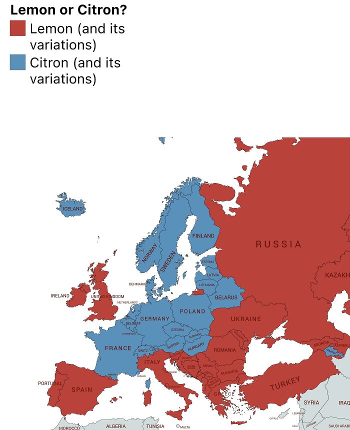
Languages Of Europe Using Lemon And Citrus
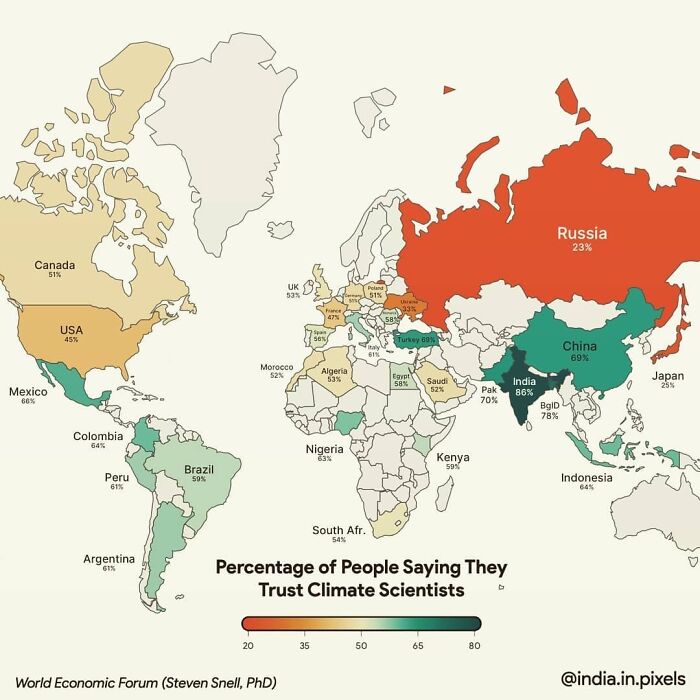
Percentage Of People Who Trust Climate Scientists, 2020
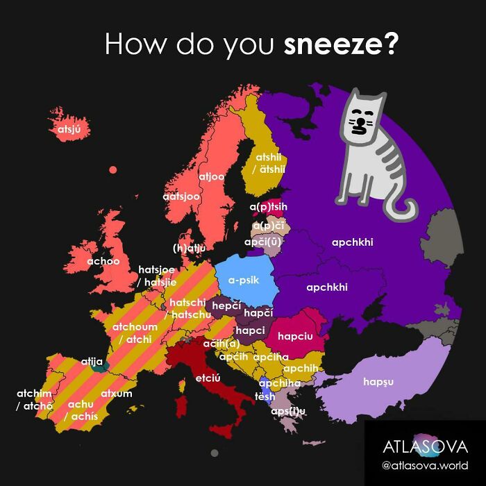
How Do You Sneeze?
As for the idea that ‘everything has been mapped,’ Patrick thinks it’s a bunch of baloney. “The world is constantly changing and accurate spatial data is a fleeting thing. Google Maps certainly gives the impression that everything is mapped, but there is selection and generalization in their data," he said that there will always be a need for new, fresh, updated maps.
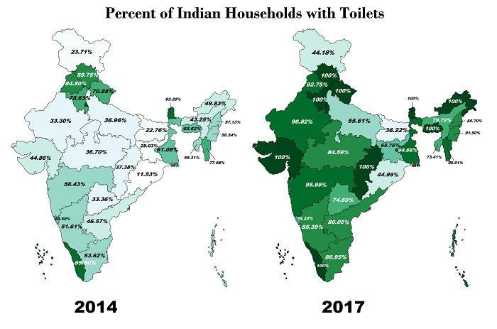
Percentage Of Indians With Toilet 2014 vs. 2017
That's one of the few decent things Modi has done right for India-toilets and electricity nationwide. Didn't do anything about the slums though, like idk, HELPING them
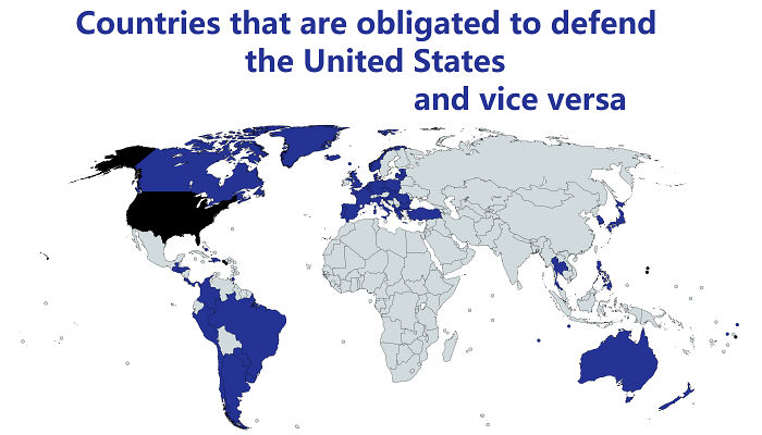
Countries That Are Obligated To Defend The United States And Vice Versa
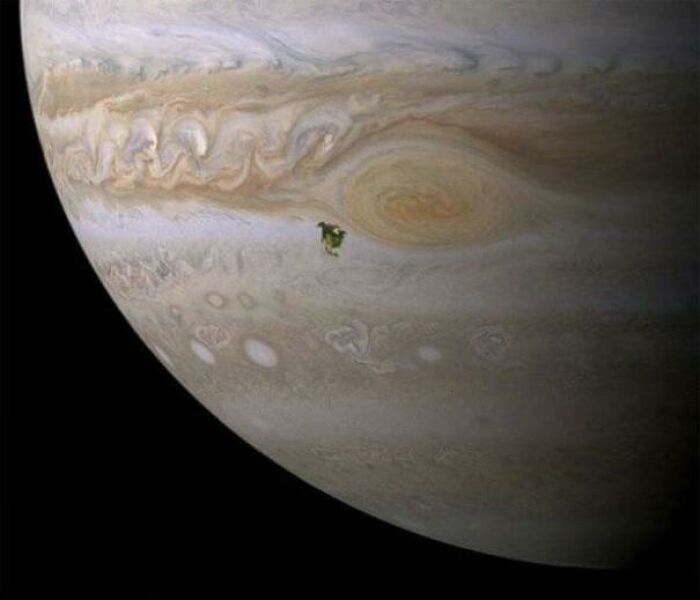
North America Compared To Jupiter
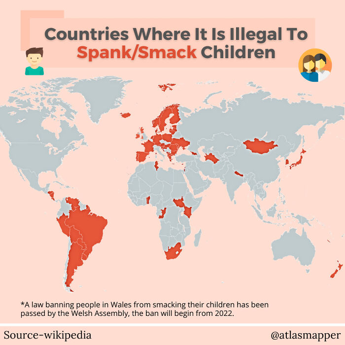
Countries Where It's Illegal To Smack Children!
Sweden: in ten years of teaching at middle and high schools with 30% immigrant kids, never had a fight that drew blood. First week in US kid was put in the hospital. Don't have to do school shooting drills either
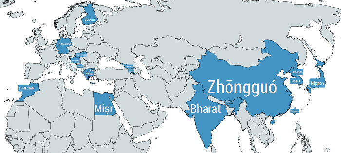
Countries Whose Local Names Are Extremely Different From The Names They're Referred To In English
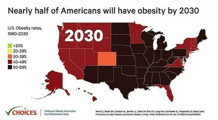
Nearly Half Of American Will Have Obesity By 2030
....Their only solution is the Mediterranean diet....with genuine, natural, products only...not adulterate foods with preservatives, colorants, even admitted by the FDA....check-out for example the list of American ingredients compared to European ones (McDonalds) and obv the portion size....
And don't forget the truly evil High Fructose corn syrup....
Load More Replies...Thank you FDA for allowing and pushing for our citizens to eat fake processed s**t that is literally killing us. Convenient for the pharmaceutical and medical/insurance companies when we all are sick. Which is all very convenient for the billionaire few who run this country from corporate bribes and rich society back rubbing. Oh sorry did I digress?
By 2030, today's fat people will be considered skinny with anorexia ...
I spent longer than necessary zooming in to find green or yellow...
That also shows coincidentally the immense difference in wealth too between those areas. I just read a study on a few days ago that discussed this exact same thing.
Doesn't surprise me. Everything down there is over processed, sugar added and served in HUGE portions.
Nah, I don't believe they are the main cause. Better ban added sugars, trans fats, added fats, high salt levels and educate on healthy foods. If that isn't enough you can always promote healthy food and demote unhealthy food by decreased/increased taxes. But banning certain food types will almost certainly get against the grain for a lot of people.
Load More Replies...Part of the problem for this, is cheap food types. The other part is the BMI. In order for me to be the middle of "normal" weight for my height, I need to be 134lbs. As a man, the only way I could even approach that, would be to actively destroy muscle mass. While in the Army at 1% body fat, I weighed 165lbs and was technically overweight. Trying to get from overweight to 'normal' would actively harm my health.
So much for finding a seat that's not overflowing with your neighbor's flab.
Is it just me who gets freaked out by states with oddly geometric borders? It's the same with African borders (because of the Europeans making a smorgasbord out of them)
Well, that's terrifying and beyond sad. I'm sure the United Kingdom is not faring any better...
Wow…I’m so glad I’m underweight…(though I still have belly fat, goddamit)
I'm sure that a lot of Americans living in Europe will tell you different.
Load More Replies...Not sure what New Zealand’s estimate is, but at the rate I’m going I’ll be out of that bracket by long before 2030.
No, the sugar levels in US food cause obesity. The food industry is adding a lot of sugar to products that don't even need it.
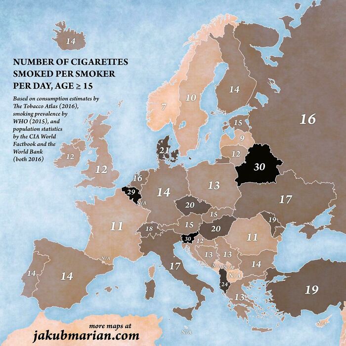
Load More Replies...Number Of Cigarettes Smoked Per Smoker Per Day In European Countries
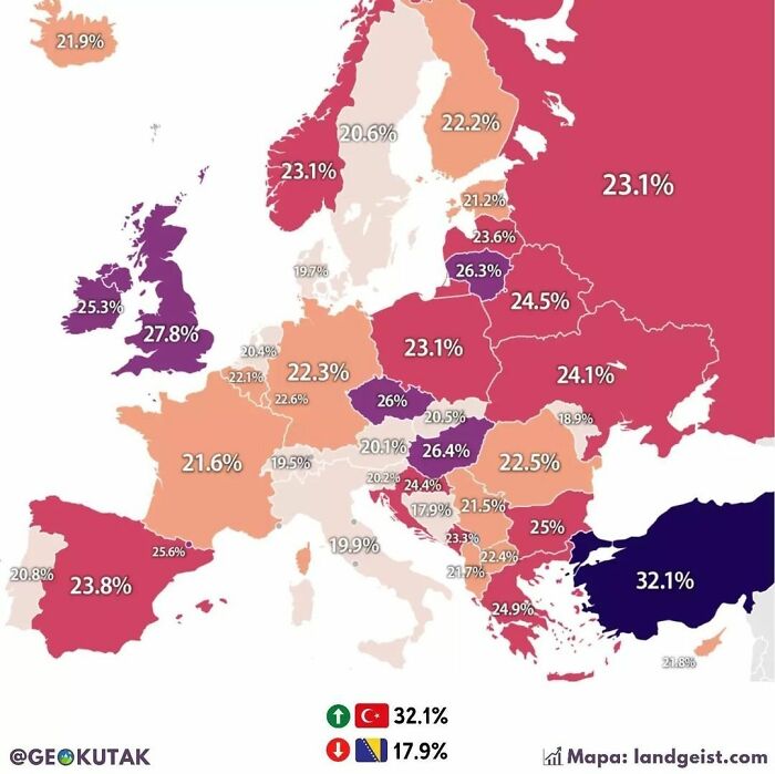
Percentage Of Obese Population Per Country In Europe
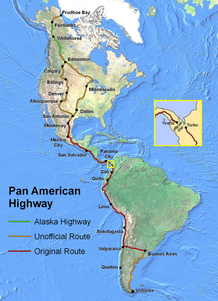
For Just A Small Space On The Pan American Highway, We Can't Drive From Alaska To Patagonia. Known As Darién Gap
I hate that this world is so dangerous for women. I would love to take a few months off, rent a car and drive that route - alone. Yet I would never dare to.
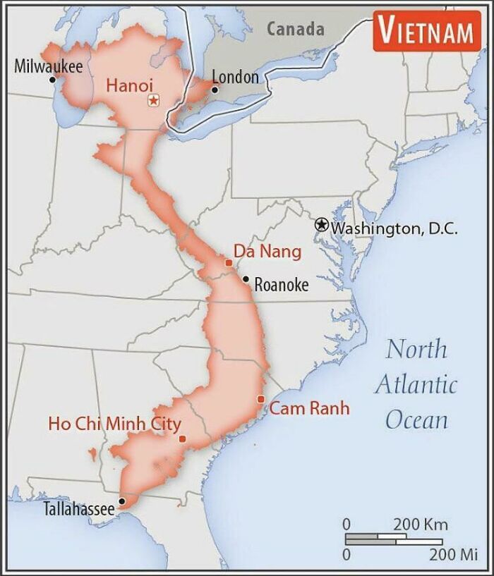
Size Comparison Of Vietnam With The Eastern United States
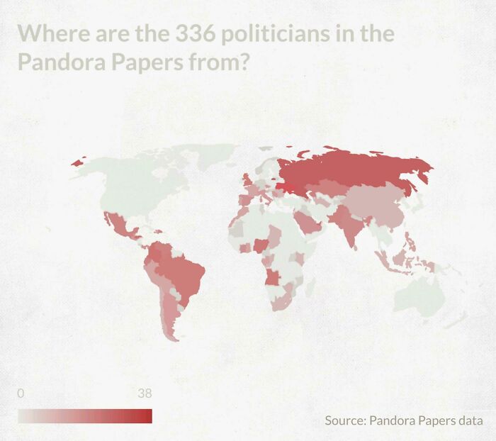
Where Are The 336 Politicians In The Pandora Papers From?
Sorry...I have a hard time believing there are no politicians with their hands in this in the USA.
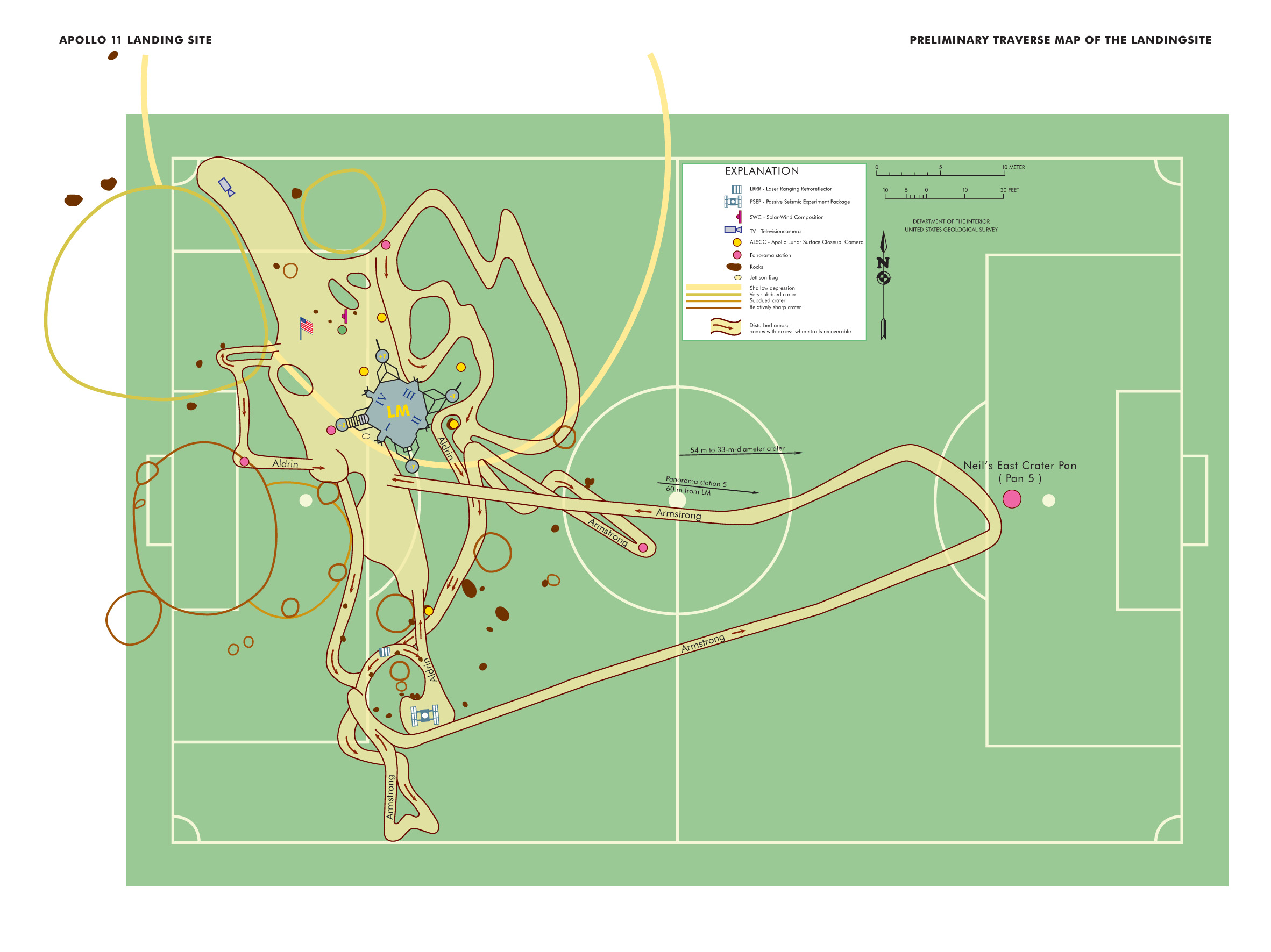
Map Of Neil Armstrong’s Moonwalk Compared To A Football Pitch. From The Nasa History Division
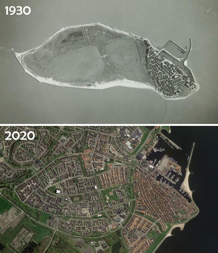
The Former Island Of Urk - The Netherlands
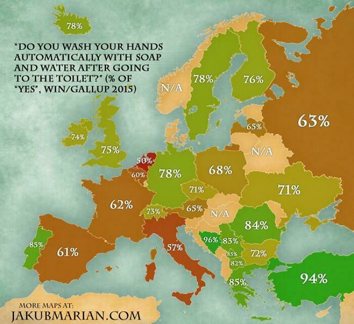
What Percent Of People From Different European Countries Wash Their Hands After Going To The Toilet
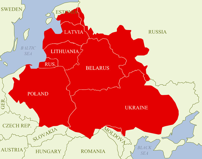
Polish-Lithuanian Commonwealth At Its Maximum Extent
To make this clearer, this was a union a long time ago and it shows how far it spread (something like the 12th century).
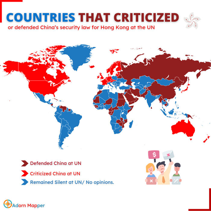
Countries Which Criticized/Defended China Security Law For Hk At Un
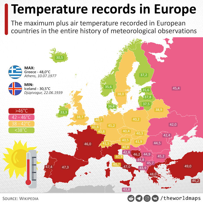
Maximum Thermometer Readings In The Entire History Of Meteorological Observations, °с
11th August 2021 the temperature in Sicily was 48,8°C. Close to Siracusa
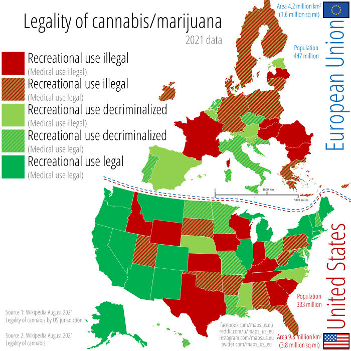
Legality Of Cannabis (Marijuana) Across The Us And The Eu. August 2021 Data
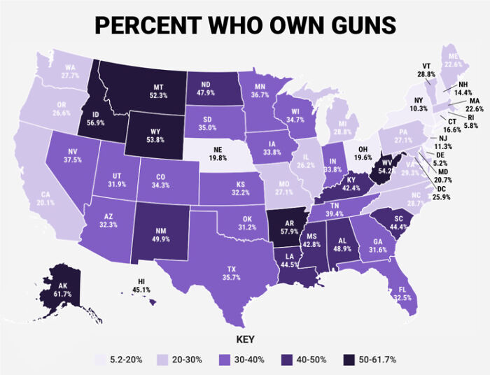
Percent Who Own Guns
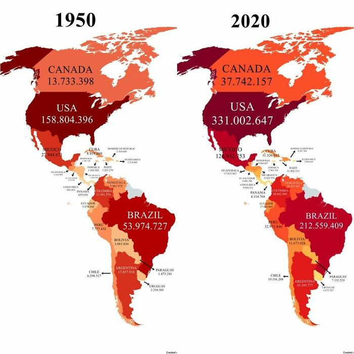
Population Of America's In 1950 vs. 2020
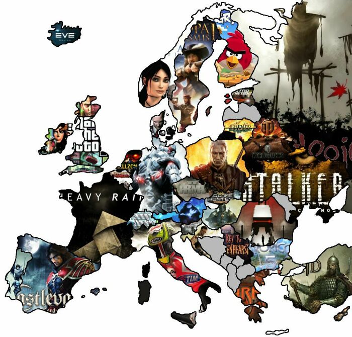
Video Game Map Of Europe (Map Of Famous Video Games Developed By Each Country In Europe)
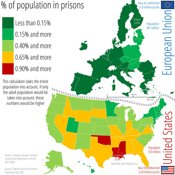
Percent Of The Population Incarcerated In Prisons Across The Eu And The Us. This Calculation Takes The Entire Population Into Account, If Only The Adult Population Would Be Taken Into Account, These Numbers Would Be Higher
In many states in the U.S., prisoners can't vote. However, prisoners do count as residents for census purposes, which impacts congressional seats and funding. Inmates are also frequently shipped to states far away from their home state for prison. This means, states who want more political power are incentived to build prisons, imprison people, and keep people imprisoned for longer to have more funding coming in and more political sway. It's a really, really awful idea that continues completely legally in the U.S.
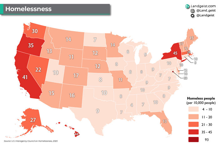
Homeless People Per 10,000 People In The United States
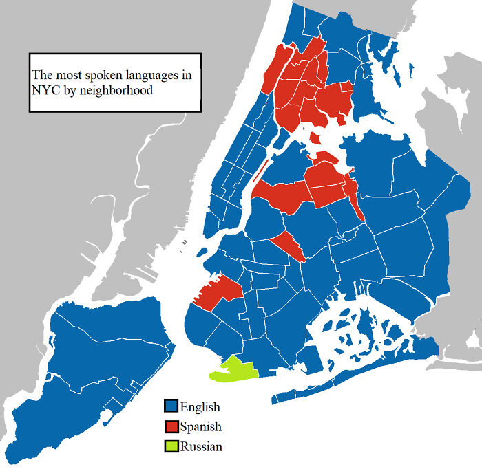
The First, Second, And Third Most Spoken Languages In NYC By Neighborhood
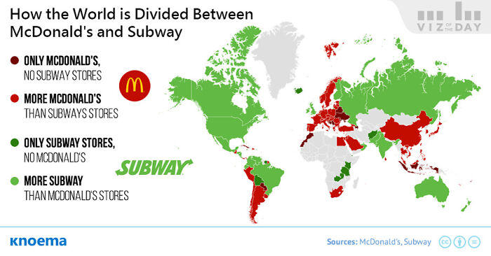
How The World Is Divided Between McDonald's And Subway
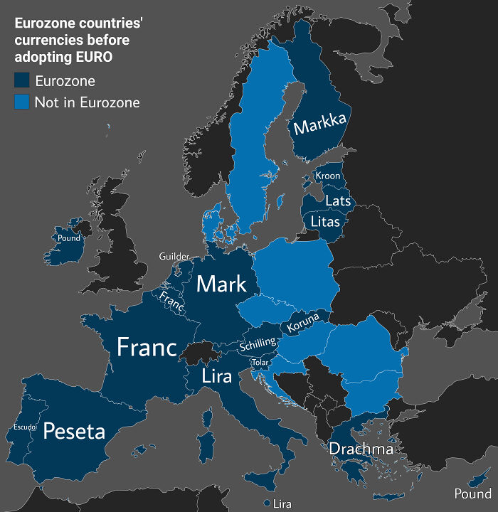
Eurozone Countries' Currencies Before Adopting The Euro
I think it's sad. Currency is a part of culture, and I hate when it changes. They also made great souvernirs before everyone got Euro.
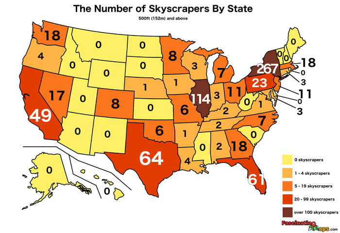
The Number Of Skyscrapers By State
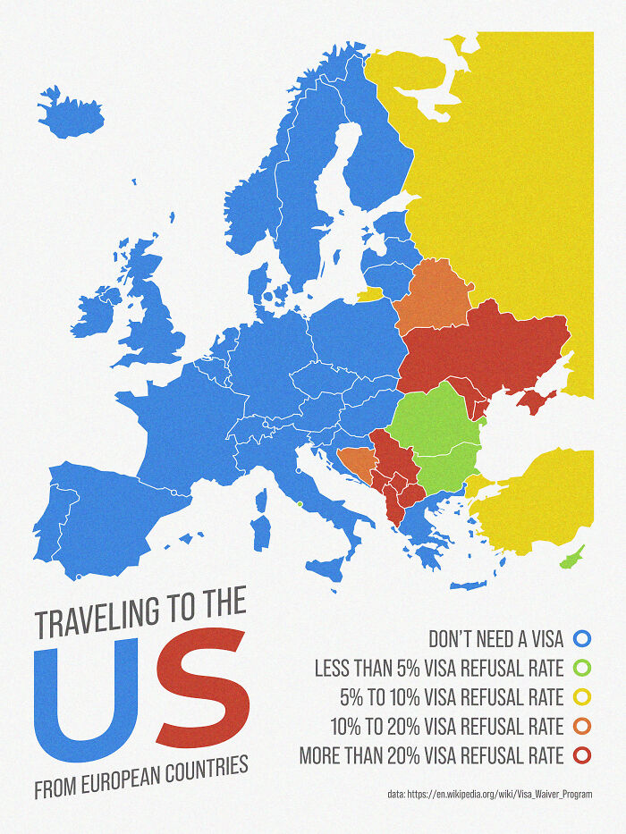
Traveling To The Us From European Countries (Visa Requirement And Refusal Rate)
Ahhh the good ole US hypocrisy. Everyone here is a descendant of immigrants who took indigenous people's land then slaughtered them, yet tons of people here hate immigrants. It wouldn't be 'Murica without hypocrisy everywhere you turn.
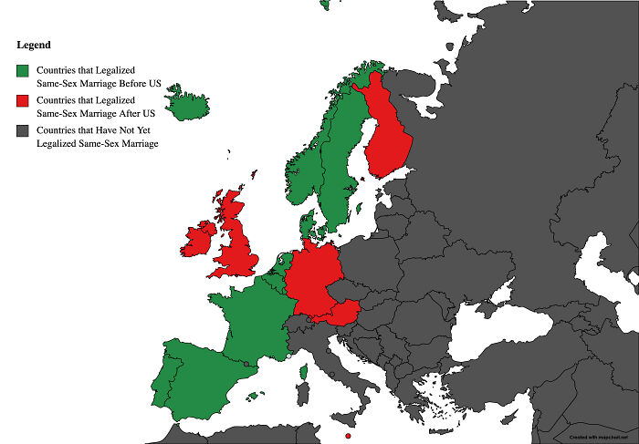
Same-Sex Legalization In Europe As Compared To The Us
So...when I compare the mappings...Is it safe to say that living with parents at high age causes criminal behavior? :)
I encourage everyone to look at Our World in Data. There are some pretty fascinating maps and graphs on there.
Most of these maps are false regarding North Africa in particular Algeria. The white skinning, the hat, the names..etc. I guess they don't have the right info so they just put what they find on Lybia although these 2 countries have nothing in common. The hats map was also wrong regarding France. That's not a French beret and it's only in Paris that people used to wear berets. The south and the north of France had different sorts of hats. That's the 2 countries I lived in and I know most so I guess that it maybe mistakes about others countries that I don't know about. I know it's not important like COVID disinformation but it gives people wrong informations and make them believe they learn something on a country when it's wrong.

 Dark Mode

 No fees, cancel anytime

