Get Premium
Dark mode theme is available exclusively for premium users. Learn more about the benefits of subscribing.
No fees, cancel anytime.

 Dark Mode Ad-Free Browsing Unlimited Content
 Ad-Free Browsing Unlimited Content Dark Mode
Join 1.2 million Panda readers who get the best art, memes, and fun stories every week!
Buckle up, wanderlusters, because Mother Nature is about to flex her most spectacular creations! From the mind-bending depths of the Grand Canyon to the depth of the Great Barrier Reef, these natural wonders make your Instagram filters look like child's play. While the "New 7 Wonders of Nature" might get all the social media glory, we're diving deep into ALL the incredible finalists that deserve your bucket list attention.
We're talking about places where mountains pierce clouds, waterfalls create permanent rainbows, and underground rivers glow like something from Avatar. Whether carved by millions of years of patience or created in explosive moments of geological drama, these 28 extraordinary sites prove that Earth was into creating viral-worthy content long before we humans came along with our cameras. Warning: This list may cause severe wanderlust and spontaneous flight booking.
This post may include affiliate links.
The Dead Sea, or Yam ha-Melah in Hebrew and Al-Bahr al-Mayyit in Arabic, is a unique salt lake bordered by Jordan, Israel, and Palestine. It sits at 429 meters (1,407 feet) below sea level, making it the lowest elevation on land, and its 304-meter (997-foot) depth makes it the deepest hypersaline lake in the world. With a salinity of 34.2% (as of 2011), it’s about 9.6 times saltier than the ocean, creating an environment where most plant and animal life cannot survive. Spanning 50 kilometers (31 miles) long and 15 kilometers (9 miles) wide, the Dead Sea has been a popular destination for thousands of years, known for its health benefits and various products, from asphalt in mummification to cosmetics. Its high density allows swimmers to float effortlessly!
The Great Barrier Reef is the largest coral reef system in the world, stretching over 2,300 kilometers (1,400 miles) and comprising over 2,900 reefs and 900 islands across roughly 344,400 square kilometers (133,000 square miles) in the Coral Sea, off Queensland, Australia. It's visible from space and is the largest structure made by living organisms. Home to a rich variety of marine life, it became a UNESCO World Heritage Site in 1981. However, challenges like climate change and crown-of-thorns starfish are harming it. The reef is vital to local Aboriginal and Torres Strait Islander cultures and generates over $3 billion annually from tourism. Google even launched a 3D Underwater Street View of it in 2014!
Milford Sound / Piopiotahi is a fiord in the south west of New Zealand’s South Island, within Fiordland National Park, Piopiotahi (Milford Sound) Marine Reserve, and the Te Wahipounamu World Heritage site. It has been judged the world’s top travel destination in an international survey (the 2008 Travelers’ Choice Destinations Awards by TripAdvisor) and is acclaimed as New Zealand’s most famous tourist destination. Rudyard Kipling had previously called it the eighth Wonder of the World.
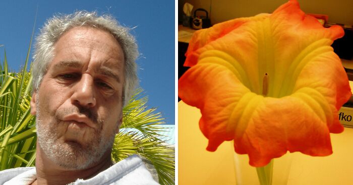
Gobustan National Park, or Gobustan Rock Art Cultural Landscape, is located in the southeast part of the Greater Caucasus mountain range in Azerbaijan. It lies near the Jeyrankechmaz River, between the Pirsagat and Sumgait rivers, and about 40 miles southwest of Baku, on the west bank of the Caspian Sea. This unique area features deep ravines and is home to ancient carvings, mud volcanoes, and gas-stones. Designated a national historical landmark in 1966, Gobustan became a UNESCO World Heritage Site in 2007 due to its remarkable rock art, which offers insight into prehistoric life and cultural evolution.
Iguazu Falls is an impressive waterfall system located on the border between Argentina's Misiones province and Brazil's Paraná state. It's the largest waterfall system in the world, splitting the Iguazu River into upper and lower sections. The river rises near Curitiba, Brazil, but most of the falls are on the Argentine side. The name "Iguazu" translates from Guarani or Tupi as "big water." According to legend, a deity created the falls in anger after a woman named Naipí fled with her lover, Tarobá. The first European to document the falls was Spanish conquistador Álvar Núñez Cabeza de Vaca in 1541.
The Amazon, spanning across nine South American nations—Bolivia, Brazil, Colombia, Ecuador, Guyana, Guyana, Peru, Suriname, and Venezuela—hosts the world’s largest forest, covering 6.7 million square kilometers. Often referred to as the "lungs of the world," it’s crucial for the planet's ecosystem and is a vital bio-reserve for these countries. The famous Amazon River runs through this forest, known for being the largest river by water discharge. Recent studies pinpoint the river’s furthest source, while its massive drainage basin, the largest in the world, processes about 20% of global river flow, making it a major environmental powerhouse.
The Grand Canyon (Hopi: Ongtupqa; Yavapai: Wi:kaʼi:la; Navajo: Tsékooh Hatsoh) is a steep-sided canyon in Arizona carved by the Colorado River. It spans 277 miles (446 km) long, up to 18 miles (29 km) wide, and reaches depths of over a mile (6,093 feet). President Theodore Roosevelt championed its preservation. The canyon reveals nearly two billion years of geological history, with the Colorado River shaping it around 5 to 6 million years ago. It has been inhabited by Native Americans for thousands of years, who regard it as a sacred site.
The Galápagos Islands, also known as Archipiélago de Colón, are a group of volcanic islands located in the Pacific Ocean, 906 km (563 miles) west of continental Ecuador. They straddle the Equator and make up part of Ecuador's Galápagos Province, including the Galápagos National Park and Marine Reserve. This unique archipelago is home to over 25,000 residents, with Spanish as the primary language. The islands are famous for their wide variety of endemic species and played a crucial role in Charles Darwin's studies during the voyage of the Beagle, which helped shape his theory of evolution through natural selection.
The Maldives, officially the Republic of Maldives, is a South Asian island nation located in the Indian Ocean, southwest of India and Sri Lanka. Comprising 26 atolls over roughly 90,000 square kilometers, it is the smallest Asian country by both land area and population, with around 393,500 inhabitants. Malé, the capital, is known as the “King’s Island.” With an average elevation of just 1.5 meters (4 feet 11 inches), the Maldives is the world’s lowest country and faces challenges from rising sea levels. The economy relies heavily on fishing and a booming tourism sector, making it one of the wealthiest nations in the region.
The Jeita Grotto (Arabic: مغارة جعيتا) is a stunning system of two interconnected limestone caves, extending nearly 9 kilometers (5.6 miles) in the Nahr al-Kalb valley, just 18 kilometers (11 miles) north of Beirut, Lebanon. While the area was inhabited in prehistoric times, the lower cave was rediscovered in 1836 by Reverend William Thomson and can only be accessed by boat due to an underground river that supplies fresh drinking water to over a million people. In 1958, the upper galleries were discovered 60 meters (200 feet) above the lower cave, featuring safe access tunnels and walkways. The upper section contains the world’s largest stalactite and impressive chambers, with the tallest reaching 120 meters (390 feet). As a national symbol and top tourist attraction, Jeita Grotto plays a significant social, economic, and cultural role in Lebanon.
Hạ Long Bay (Vietnamese: Vịnh Hạ Long) is a UNESCO World Heritage Site located in Quảng Ninh Province, Vietnam. Known as “descending dragon bay,” it is famous for its thousands of limestone karsts and islets in various shapes. The bay is part of a larger area that includes Bái Tử Long Bay and Cát Bà Island, sharing similar geological and cultural features. Covering approximately 1,553 km², Hạ Long Bay contains 1,960 to 2,000 islets, primarily limestone, with a core area of 334 km² featuring a high density of 775 islets. The limestone formations have developed over 500 million years, with the karst landscape shaped over the last 20 million years by a tropical wet climate. This rich environment supports a diverse ecosystem, including 14 endemic plant species and 60 endemic animal species. Evidence suggests that prehistoric humans inhabited the area tens of thousands of years ago.
The Puerto Princesa Subterranean River National Park, also known as the Puerto Princesa Underground River, is located about 80 kilometers (50 miles) north of Puerto Princesa City, Palawan, in the Philippines. This protected area lies in the Saint Paul Mountain Range along the island's western coast, bordered by St. Paul Bay to the north and the Babuyan River to the east. Managed by the City Government of Puerto Princesa since 1992, the park features an accessible entrance just a short hike or boat ride from Sabang. In 2010, environmentalists discovered a second level in the underground river, revealing small waterfalls and a dome that rises 300 meters (980 feet) above the river. The caves also host rock formations, large bats, various wildlife, and challenging deep areas that are difficult to explore due to low oxygen levels.
Table Mountain, known as Hoerikwaggo in Khoikhoi and Tafelberg in Afrikaans, is a flat-topped mountain and a prominent landmark overlooking Cape Town, South Africa. As a major tourist attraction, many visitors either hike or take a cableway to its summit. The mountain is part of Table Mountain National Park and features a flat plateau about 3 kilometers (2 miles) wide, edged by stunning cliffs and flanked by Devil’s Peak and Lion’s Head. The highest point, marked by Maclear’s Beacon at 1,086 meters (3,563 feet), offers breathtaking views. The mountain is often shrouded in orographic clouds, creating a "table cloth" effect, a phenomenon associated with local legend. To the south lies the Back Table, while the Twelve Apostles are located along the Atlantic coast, continuing south to Cape Point.
The Matterhorn, known as Monte Cervino in Italian and Mont Cervin in French, is a prominent pyramid-shaped mountain in the Alps, straddling the border between Switzerland and Italy. Standing at 4,478 meters (14,692 feet), it ranks among the highest peaks in the Alps. The mountain features four steep faces that rise over glaciers and are separated by Hörnli, Furggen, Leone, and Zmutt ridges. Overlooking Zermatt in Switzerland and Breuil-Cervinia in Italy, the Matterhorn is a historical climbing destination. Its first ascent occurred in 1865, led by Edward Whymper, but ended tragically with the deaths of four climbers. Known for its iconic shape, the Matterhorn attracts many mountaineers and tourists, particularly via the popular northeast Hörnli ridge route. It is celebrated as an emblem of the Swiss Alps and has been part of the Swiss Federal Inventory of Natural Monuments since 1983.
The Cliffs of Moher (Irish: Aillte an Mhothair) are stunning natural cliffs located in County Clare, Ireland, at the southwestern edge of the Burren region. They rise 120 meters (390 feet) above the Atlantic Ocean at Hag’s Head and reach their peak height of 214 meters (702 feet) near O’Brien’s Tower, eight kilometers to the north. Built in 1835 by Sir Cornelius O’Brien, the tower offers breathtaking views of the Aran Islands, the Maumturks and Twelve Pins mountain ranges, and Loop Head.
Windiest place I've ever been. So windy that I had to turn my back to it in order to breathe.
Jeju-do, or Jeju Island, is a volcanic island spanning 1,846 square kilometers, making it the largest island off the coast of the Korean Peninsula. Located in the Korea Strait, southwest of South Jeolla Province, it is the main island of Jeju Province in South Korea. Jeju is home to the UNESCO World Heritage Site, Jeju Volcanic Island and Lava Tubes, and features Hallasan, the tallest mountain in South Korea and a dormant volcano, standing at 1,950 meters above sea level. The island was formed about 2 million years ago from volcanic eruptions during the Cenozoic era and features basalt and lava. Jeju has a humid subtropical climate, with cooler, dry winters and hot, humid summers.
The Jeju Fire Festival is one of the most over-the-top pyrotechnic displays in the world. They also have unique breeds of cattle, pigs, and horses. The pigs and cattle may go back to the Neolithic Revolution! The horses were probably introduced in the 11th - 12th century.
El Yunque National Forest, located in northeastern Puerto Rico, is the only tropical rainforest in the U.S. National Forest System. The forest, formerly known as Luquillo National Forest, encompasses 28,000 acres (113.32 km²) and is situated on the slopes of the Sierra de Luquillo mountains. The highest peak, El Toro, reaches 1,065 meters (3,494 feet). El Yunque, named after a possible Taíno word meaning "white lands" or the Spanish word for "anvil," features lush foliage, waterfalls, and rivers due to its high rainfall (over 200 inches per year). Numerous trails allow visitors to explore its diverse flora and fauna and view unique Taíno petroglyphs.
Mount Vesuvius (Italian: Monte Vesuvio) is a stratovolcano located about 9 kilometers (5.6 miles) east of Naples, Italy. It is famous for its AD 79 eruption, which buried the cities of Pompeii and Herculaneum under ash and debris, killing at least 1,000 people. The eruption expelled ash and rock to a height of 33 kilometers (20.5 miles) and released immense energy. Vesuvius has erupted many times since and is considered one of the most dangerous volcanoes in the world, with around 3 million people living nearby. Its explosive eruptions make it the most densely populated volcanic region globally.
Mount Kilimanjaro, a dormant volcano in Tanzania, is Africa's highest mountain, rising approximately 4,900 meters (16,000 feet) from its base to 5,895 meters (19,341 feet) above sea level. It features three volcanic cones: Kibo, Mawenzi, and Shira. The first recorded ascent to the summit was achieved by Hans Meyer and Ludwig Purtscheller in 1889. Kilimanjaro is part of Kilimanjaro National Park and is a popular destination for climbers. The mountain has also been the focus of various scientific studies due to its shrinking glaciers.
Kerepakupai Meru, also known as Salto Ángel or Angel Falls, is located in Venezuela and is the world’s highest uninterrupted waterfall, with a height of 979 meters (3,212 feet) and a plunge of 807 meters (2,648 feet). It cascades over Auyantepui mountain within Canaima National Park, a UNESCO World Heritage site in the Gran Sabana region of Bolívar State. The total height of 979 meters includes the main plunge, approximately 400 meters of sloped cascade and rapids below the drop, and a 30-meter (98 feet) plunge downstream. The falls are situated along a fork of the Rio Kerepacupai Meru, which feeds into the Churun River, a tributary of the Carrao River and ultimately the Orinoco River.
Komodo is one of Indonesia's 17,508 islands and is famous for being the habitat of the Komodo dragon, the largest lizard on Earth. The island covers an area of 390 square kilometers and has a population of over 2,000 residents, primarily descendants of former convicts and Bugis from Sulawesi. The inhabitants mostly practice Islam, with some Christian and Hindu communities. Komodo is part of the Lesser Sunda Islands and includes the Komodo National Park. It is also a popular diving destination and falls under the East Nusa Tenggara province.
Uluru (Pitjantjatjara: Uluṟu), also known as Ayers Rock, is a large sandstone rock formation located in the southern part of the Northern Territory, Australia. It is situated 335 kilometers (208 miles) southwest of Alice Springs and 450 kilometers (280 miles) by road. Along with Kata Tjuta, Uluru is a prominent feature of Uluṟu-Kata Tjuṯa National Park. The rock is sacred to the Pitjantjatjara Anangu, the local Aboriginal people, and the surrounding area features springs, waterholes, rock caves, and ancient paintings. Uluru is recognized as a UNESCO World Heritage Site.
Yushan (Chinese: 玉山; pinyin: Yù Shān), or Jade Mountain, is the highest peak in Chinese Taipei at 3,952 meters (12,966 feet) and the fourth highest on an island. Previously known as Mount Morrison, it earned its name due to its snow-capped peak resembling jade. Yushan was a finalist in the New7Wonders of Nature campaign in 2009. Located in Yushan National Park, Taiwan's largest and least accessible national park, it boasts diverse endemic species. Yushan's formation resulted from the Eurasian Plate sliding over the Philippine Sea Plate, with ocean depths exceeding 4,000 meters (13,100 feet) off the east coast.
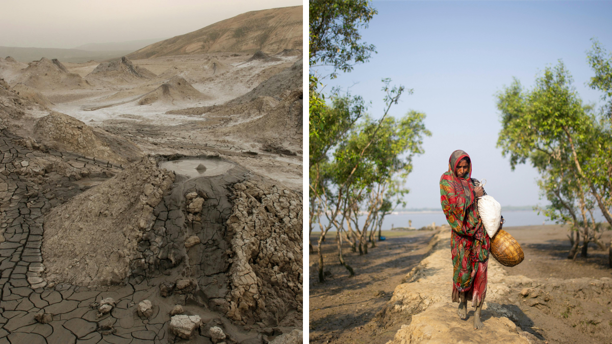
The Sundarbans (Bengali: সুন্দরবন, Shundôrbôn) is a natural region spanning southern Bangladesh and part of West Bengal, India. It is the world's largest tidal halophytic mangrove forest, covering approximately 10,000 square kilometers (3,900 sq mi), primarily in Bangladesh. The Sundarbans is a UNESCO World Heritage Site and includes three protected forests in Bangladesh: Sundarbans South, East, and West. This area is known for its dense mangrove ecosystems and serves as the largest reserve for the Bengal tiger. Additionally, the Sundarbans National Park is a Tiger Reserve and Biosphere Reserve located in the Indian delta.
Bu Tinah (Arabic: بوطينة, Būṭīnah) is a small archipelago in the United Arab Emirates, located 25 km south of Zirku and 35 km north of Marawah. It is part of the Marawah Marine Biosphere Reserve, the region's first UNESCO-designated marine biosphere site. Closed to visitors, Bu Tinah is rich in biodiversity and supports mangroves, coral reefs, and endangered species like the hawksbill turtle and dugongs. The island's thriving marine habitat is important for climate change research, demonstrating resilience in high temperatures and salinity, and it is a designated protected area in Abu Dhabi.
The Black Forest (German: Schwarzwald) is a mountainous forested region in Baden-Württemberg, southwestern Germany. It stretches approximately 160 kilometers (99 miles) long and up to 60 kilometers (37 miles) wide, bounded by the Rhine valley to the west and south. The highest peak is Feldberg, at 1,493 meters (4,898 feet). This region is primarily wooded and composed of crystalline basement rocks and Bunter Sandstone. Its natural boundary features a vegetation line that separates the fertile Altsiedelland from the less inhabited Black Forest, which saw permanent settlement during the High Middle Ages. Tectonically, it appears as a raised fault block, resembling a heavily forested plateau from the east.
Masuria (Polish: Mazury; German: Masuren) is a picturesque region in northern Poland, renowned for its 2,000 lakes. Once part of East Prussia inhabited by Polish-speaking, Lutheran Masurians, it occupies much of the Masurian Lake District and is included in the Warmian-Masurian Voivodeship, with Ełk as its largest city. Covering about 10,000 km² and home to around 500,000 people, Masuria is known as Kraina Tysiąca Jezior in Polish and Land der Tausend Seen in German. The lakes, formed by glaciers during the Pleistocene ice age, create a hilly terrain interspersed with rivers and forests, which cover about 30% of the area.
The Bay of Fundy (French: Baie de Fundy) is located on the Atlantic coast of North America, between New Brunswick and Nova Scotia in Canada, touching a small area of Maine. The name "Fundy" may derive from the French word "Fendu" (meaning “split”) or the Portuguese "funda" (meaning “deep”). Known for having the highest tides in the world, Burntcoat Head in Nova Scotia features a mean spring range of 14.5 meters (47.5 feet). The bay is part of the Western Hemisphere Shorebird Reserve Network and is managed by New Brunswick, Nova Scotia, and the Canadian Wildlife Service.


 No fees, cancel anytime


")
")