Get Premium
Dark mode theme is available exclusively for premium users. Learn more about the benefits of subscribing.
No fees, cancel anytime.

 Dark Mode Ad-Free Browsing Unlimited Content
 Ad-Free Browsing Unlimited Content Dark Mode
Join 1.2 million Panda readers who get the best art, memes, and fun stories every week!
Because architectural facades are noticed first, the beauty of urban design is often overlooked. But thanks to the World Urban Planning Instagram account, we can see a city’s framework in full view.
The page features stunning aerial images of Copacabana's picturesque coastlines, distinct and innovative infrastructures in Saudi Arabia, and lush greenery in a forested suburb in the Netherlands, among others.
We've put together some photos that stood out. Scroll through this list and see the world in a different light, literally.
This post may include affiliate links.
A well cared tree row covers a huge area just north of Sapporo city. The urban forest surround the community, and connect two green areas together. Such urban forest contribute to a more walkable, livable and sustainable city (and has contributed to the identity of the place). Not only do they help in the removal of pollutants from air and water, but also contribute to more green and vibrant neighborhoods. Streets become more enjoyable to walk along. Urban green space enhance the quality of our daily lives and can return millions of dollars annually in health benefits.
I had a look at Google Earth and the whole thing is actually huge. This image is of course completely oversaturated making it look like a jungle.
Google satellite view, it really looks that green. BP is not letting me post the screen shot.
Load More Replies...G Map link - https://www.google.com/maps/place/43%C2%B008'58.2%22N+141%C2%B017'45.9%22E/@43.149493,141.2935127,17z/data=!3m1!4b1!4m13!1m8!3m7!1s0x5f0ad4755a973633:0x33937e9d4687bad5!2sSapporo,+Hokkaido,+Japan!3b1!8m2!3d43.0617713!4d141.3544507!16zL20vMGdwNWw2!3m3!8m2!3d43.149493!4d141.296093?entry=ttu
This is the kind of urban hell that planners love to inflict on hapless population: All of the pleasant greenery in one rigidly controlled place, NOTHING anywhere else. Please show me which streets "become more enjoyable to walk along."
Palmanova was built in 1593 during the late Renaissance period. It is one of the many old star forts from this period. This 9 pointed star fort, designed by Vincenzo Scamozzi, is an attempt to follow the ideals of an utopian city. In 1960 the fort was declared to be of national treasure and became a national monument, and in 2017 it was included in UNESCO’s World Heritage Site list.
1590s: This design will help ward off the Saracen raiders, who spread plague and rape our women and slaughter our children! 2020s: *gasp* a flower-shaped city!
Saracen is a crusade thing... Timeline is way off. They also don't raid since they were a defensive force. You are thinking of the Umayyad Caliphate as if they are rapists and slaughterers i would say yes since they were also doing a crusade(Jihad in arabic) and that is what crusaders do... Source: My name and the internet.
Load More Replies...Rennes's history goes back more than 2,000 years. Rennes has grown incredibly since the 1950s, with its rural flight and the industrial development. During that time the city had great building plans to gain a population of 200,000 inhabitants. Today it has 700,000, and is the seventh biggest city in France. ⠀ ⠀ Here from a more rural development north of the city centre. A spiral development.⠀ ⠀
It's pretty to look at, but in the end it's the same urban nightmare you see in any small town. Very crowded in the center too
This is all residential, and I do t think it’s crowded. Looks fine to me.
Load More Replies...None of these have any of the sort of easy-to-walk-to commerce that BPs are always hating on America for lacking.
In the UK we have the ubiquitous corner shop which are everywhere, in France they’ll have a tabac pretty much everywhere and anywhere.
Load More Replies...Not really. Have lived in many cul-de-sacs in my life and I’ve never known any trouble with cars and one road. It looks wide enough to take two cars passing each other quite easily.
Load More Replies...The World Urban Planning Instagram page has over 65,000 followers as of this posting. In addition to significant landmarks, it also features specific spots in each country, such as the Shanghai World Expo site, the BMW Tower in Munich, and this highway roundabout in the middle of the desert in the UAE.
Brondby Garden City is located just a mere 15km west of Copenhagen. ⠀ Garden Cities have commonly been inspired by Ebenezer Howard’s Garden City concept; improving quality of urban life by establishing small peripheral garden cities around a central city. ⠀ ⠀
In 1964 the municipality of Brondby agreed to reserve an area for a "garden city". The architect wanted the gardens to be divided into circular shapes. He explained that the shape was to symbolise a historical village where people met at the well located in the center. By designing this way, the architect believed social interaction would increase between residents.
It seems that the "well meeting-place" of the traditional village in the architect's vision has become a car park. That pretty much sums up what's wrong with life today. Imagine if there was a communal fire pit and seating area under a beautiful big tree or something instead and the cars were kept out of the way.
Where would you park the car? I would also advise against building a fire pit directly under a large tree.
Load More Replies...This seems like something you'd see in a dystopian movie where everyone thinks the place is paradise, but one person finds that not everything is as it seems.
All that space with grass, they should plant trees and shrubs. To me these look like crop circles .....
Maybe grasses are actually what are native to that area? Grasses are actually massive oxygen produces and if there are wildflowers on the mix, will be really important for continuing pollination.
Load More Replies...I'd add a road and garages on the outside of the circle. Leave the inner circle for visitors and UPS. Also, how about some more bike paths, walking paths, parks, dog parks, or playgrounds between the circles - time to update. Maybe, connect the circles better rather than isolate them. Also, how about some local retail along the road.
I'd like the idea of all the common space, but it's all just empty lawns. To me, the ideal home (for a family with kids) would have some lawn under direct ownership of the homeowner for the kids to play in and to relax around your home, a much bigger common field for common use for larger games or play that takes a larger area (kite flying, frisbee, etc.), and a nice amount of woods in a more natural state between the homes.
I bet people fight over parking. Also who wants to carry their stuff that far to the house?
Port Ariane is a port located in Lattes. Lattes is a small commune with about 16.000 inhabitants. The city centre experience flooding once in a while so dykes and a spillway was built the past years. Fascinating circle-shaped marina area with a small park in the middle.
The fort is located just north of the town Elvas bordering Spain. The town has some of the best preserved military architecture (star forts) and was designated as a UNESCO World Heritage Site in 2012. The fort, more commonly known as Forte Conde de Lippe (named after its designer Marshal Lippe), is approximately 150 metres quadrangle with pentagonal bastions in the corners. In the centre of the fort we find a decorated chapel. ⠀
It's where the city population fled to in time of war?
Load More Replies...Actually, star forts have five points, not four. Complete visibility of 360 degree line of sight. I live near a star point fort. Five corner points.
Star forts can have a variety in the number of points. The simplest had four primary bastions (the points), where more complicated ones could have six, seven, even twelve or more. The "trace italienne" - the name of this type of fortification - was merely a method of constructing fortified positions using math, earthworks (to absorb cannon fire), and overlapping fields of fire. Then the nerds had to go and name all the bits, so you've got bastions and redoubts and glacis' and scarps and counterscarps...
Load More Replies...But starforts are usually surrounded by water. They built one on land?
Singapore is one of the highlighted locations on the page. This island country/city-state is esteemed for its impeccable urban planning. Airline Cathay Pacific described it as “the best-planned city in the world.”
In Portugal we can see how a more modern 60-70s suburban development has been built in the vicinity of the old city of Lisbon. The aerial view shows residential apartment buildings connected into a large residential complex. Carnaxide is a former third level administrative subdivision (civil parish) in the municipality Oeiras. It dates back to the 13th century when it became the first suburban parish of Lisbon.
I hate this. Aerially, it looks kinda cool, but everyone is trapped in parking lots and has to wander quite a way to see something other than similar-looking buildings. I'd actually prefer one giant high-rise, frankly; for the same population density, at least you could have plenty of greenspace. Real greenspace, not just tree canopies blocking the sight of parking lots from the overhead cameras.
Polysaccharide. Carbon tends to form 6-carbon rings, and although its inaccurate, (they're schematic not representational of actual form), this is how they're often represented.
Load More Replies...Suloszowa is a small village with almost 6,000 inhabitants, and has one of the longest streets in Poland (stretching 9 km non-stop) as shown in the image. Suloszowa is located just 29 kilometres northwest of Krakow, and is connected to famous attractions including Ojcowski National Park and Pieskowa Scala (14th century cliffside castle).
If it were pretty much any other shape it would take less space and take less travel to go from place to place.
Correct, but this way there is an immense amount of space for agriculture
Load More Replies...And Auschwitz isn‘t far either! (Only 1h drive lol). And just so you know: Auschwitz is called Oświęcim in Polish.
Ancient farms are long rectangles because it wastes less time for the horse to make corners
Pretty typical mediaeval town construction. Houses all together at the center with long narrow fields behind each one.
The now famous, but at that time radical, urban planner Ildefons Cerdà designed the grid pattern in Barcelona named Eixample. The design has long straight streets, wide avenues, and octagonal square blocks with rounded corners placed in a strict grid pattern. This has given better visibility, air and is the grand aerial landmark of Barcelona.⠀
I bet you can hear your neighbors very well. I think they might want to go with some new high rise buildings instead.
I was thinking how close the buildings look! I would hate to be so close to everyone like that
Load More Replies...If I am not mistaken, most of those trees are fruit trees. Free for the picking.
With a landmass size of 720 square kilometers (roughly 278 square miles), Singapore’s city planners had to be purposeful with their land use.
Dr. Liu Thai Ker is primarily credited with Singapore’s modern architecture. One of his insights focused on long-term planning.
Venice in Italy is archipelago of 117 islands formed by 177 canals in a shallow lagoon, and connected by 409 bridges. In the old centre, the canals serve the function of roads, and almost every form of transport is on water or on foot.
That's not really urban planning either - it's just "build on whatever bit of land you can find" because it's an island.
Much of it isn't even land. It is mud with piles driven into it!
Load More Replies...Have you seen the video of the gondolier in Venice who's singing and rowing and then whacks his head on the bottom of a bridge? If you haven't, go to YouTube and search "gondolier hits his head on bridge". It's hilarious - and he was fine so it's OK to laugh. :)
Trivia: Igor Stravinsky and his wife are buried on the square island on the left
Fun fact: Venice is NOT the city with the most bridges in the world. (It‘s Hamburg/ Germany with 2500 bridges).
Did not know it had that many islands. Are these the main ones in photo?
The famous monument Arc de Triomphe is located in Paris. It honours the ones who fought and died in the Napoleonic wars and French revolution. It was designed by Jean Chalgrin, in 1806, who was inspired by the Roman Arch of Titus, and in 1836 the construction finished. It was the tallest triumphal arc with a height of 50 meter, but the Momento a la Revolución (67m) in Mexico and the Arch of Triumph (60m) in North Korea exceeded its height in 1938 and 1982 respectively.
There are cars travelling around the circle which can't get out. Family members bring them food, throw it through the windows.
en tant que français je peux dire que its not great planning, its painful to pass through
Isn't this called "Place de L'Etoile"? Place of the Star, as the streets make a star design.
those wide roads are exactly how the Germans drove right into Paris during WWII
Was there really a reason to mention the North Korean knock-off? Since this site loves bashing America, here's a funny one: Boston is probably the most European of all major American cities. Somewhat more coincidentally, there is a certain point in the city that is visible from so much of the rest of the city. Unfortunately, instead of a triumphal arc, it's a neon sign for a gas company largely owned by a Latin-American dictator. It overshadows Fenway [baseball] Park, home of the Boston Red Sox.
Lombard Street is perhaps the most famous crooked street in the world with 2 million yearly visitors. It is a one-way block where eight sharp turns (total of 600 feet/180 meters) help reduce the steepness. It was built in 1922 to reduce the hill's natural steep 27% grade, which was far too steep for the most common cars.
Living there must be annoying with the constant swarm of tourists (including me many times) driving down it.
The owners are constantly whining about the traffic and the tourists. And each and every one of them knew they were buying in a high-traffic tourist location when they bought there. They can collectively and individually go pound sand.
Load More Replies...I was also thinking of that. I was imaging taking a sled down after a major snow (not that there would be a blizzard there, just thinkging of the fun)
Load More Replies...There is another like this on another hill: Vermont Street on Potrero Hill. But it is south of the touristy area.
I had a doc on Lombard Street in North Beach and I used to cut through this way as it was a lot shorter than going around.
I believe the street is now closed to traffic and is pedestrian only, or only open to residents' cars.
But what I am wondering is, what about the nearby parallel streets? Why is it just the one street like that?
San Francisco is built on multiple hills with different heights and slopes. Lots of the hills and the streets on them are steep.
Load More Replies...“In 1971, when we were still very poor, we already laid down the MRT lines on paper,” he said in a 2017 interview. “We had no money, and we went through a lot of debates on whether we should have the MRT or not.
“In 1982 when we had the money and decided to build the MRT, the lines were already there and the land had already been acquired.”
Bern's old city was built on a narrow hill surrounded by the river Aare on three sides. The compact layout of the city has barely changed at all since its construction between the 12th and 15th century, and has kept its medieval character. In 1983 the old town was listed as a UNESCO World Heritage Site for its original medieval character. A great city where public transportation, biking and walking is a pleasure.
At the north end of the north bridge (on this map), you can see the pit where they keep the bears...
The shapes the red roofs form make it look like chorizos, and I love me some spicy chorizos! =P
Grammichelle was built in 1693, and was laid out with six roads circling around the central square where you find the Town Hall and Mother Church. The six roads later expanded to more roads. Today it is one of the many hexagonal baroque towns you can find in Sicily.
I was also going to make a comment about the lack of trees. This is unreal, with such a lack of trees.
... this looks terrible, no green at all... Will get really hot in summers!
It's a Sicily guys! It's hot and dry. What trees are you talking about? It's hard to grow anything taller than 3 -4 metres and that's not enough to give you proper shade. Narrow streets and tall buildings is the best way to combat heat.
So a big parking lot dominating the city center is cool, just as long as there are no cars in it? I'm being snide; I Googlewandered it a bit, and it seems very pretty, but I'm tweaking the BPs who hate hate hate hate hate hate hate hate hate American cities because they're car-friendly.
It was built in 1693. It sure as hell is not going to be a "parking lot". It is a square, probably used for a market, a kind of temporary shopping mall that appears on certain days of the week! ;-)
Load More Replies...Central Park opened to the public for the first time in 1858 as a 778 acre or 3sq.km park (later on expanded to 843 acres or 3.41sq.km). The park is approx. 4 km long and 1 km in width. To walk across the entire park it would take you approximately 45 minutes. Many think Central Park is one of the largest city parks in the USA, however even San Fransisco’s Golden Gate Park is 20% bigger in size.
And they completely destroyed Seneca Village: https://en.wikipedia.org/wiki/Seneca_Village
Not sure why you got voted down for showing the actual history of the place, balance it out with an upvote :)
Load More Replies...Fairmount Park in Philadelphia is almost three times bigger and Forest park in St. louis is almost twice as big. Central park is actually rather small comparatively.
Neither of them have the clean, straight lines that would indicate the same type of city planning that went into Central Park though.
Load More Replies...Isn't that the place where every main character get mugged or meet scary people in every film in New Your ever made?
Fun fact, the man who designed Central Park is an ancestor of Kim Cattral.
Load More Replies...and this is exactly why shows like Friends always felt unrealistic to me? You literally have to pay millions and wait years to rent an apartment close to central park, let alone with a view
Load More Replies...If you mean the blue roof buildings center right, that’s the Metropolitan Museum of Art.
Load More Replies...A 1 km x 4 km rectangle would have an area of 4 sqkm. Also, it does not take most people anywhere near 45 minutes to walk a km. Some paths in the park are twisty and you could spend hours walking through the park, but there are also more direct routes and you can cross the park in about 15 minutes
I think they mean top to bottom as shown in this picture.
Load More Replies...Urban planner Jason Satori spoke to National Geographic about studies linking city planning to obesity. In his work, he has focused more on public health.
“When we design cities in ways that require people to drive rather than walk, and when we design streets that make biking dangerous, we discourage people from engaging in physical activity."
Runaway Bay is a suburb on the Gold Coast in Queensland, Australia. In 1967, a company bought 182 hectares of land along the western shore of the Gold Coast Broadwater. Development of the area started in 1972 where they had the goal of transforming it into a residential and boating area. The name "Runaway Bay" was coined to promote the area as a tranquil retreat. As other Gold Coast suburbs, many of the homes in Runaway Bay are situated along artificial canals.
Great for so many homes to be fronting water, but the area seems a bit short on bridges.
Yeah, Lotekguy, I definitely think they could use more bridges. Some people have such a long car drive to reach a neighbor right across the water.
Load More Replies...I'm thinking crocodiles, sharks, jellyfish, stingrays, sea snakes, kraken, rancors, gungans and the creature from the black lagoon.
Why so skeptical? Certainly there can't any animals or critters more dangerous than koalas on that idyllic continent. You're thinking of Florida.
Load More Replies...What's the use of a house with next to no yard around it and the neighbours staring directly in your living room?
some people prefer to have no yard so they don´t have to maintain it.
Load More Replies...The Forbidden City (紫禁城) was the Chinese imperial palace, which was the home of emporers and the political centre, from 1420 to 1912. It is located in the centre of Beijing and today houses the Palace Museum. Inside, the 180 acre palace ground, we find 980 buildings with a total of 8,886 rooms. Outside, it is surrounded by huge imperial gardens. The palace exemplifies traditional Chinese palatial architecture, and has influenced the cultural and architectural developments both in East Asia and globally. In 1987, the Forbidden City was declared a World Heritage Site and is listed by UNESCO as the world's largest collection of preserved ancient wooden structures.
Been there. January. -30°C without factoring wind chill. It was PACKED, I was wearing eight layers and still incredibly cold.
And ever-so-slightly off-kilter. I'm hyperventilating just thinking about it.
Load More Replies...This picture looks like a plastic kit for model robot, hanging in a supermarket.
Golden Gate Park is a huge 1,000 acre park. Back in the 1860s San Franciscans felt a need for a spacious park similar to NYC's Central Park which was at that time under construction. Golden Gate Park, established in the 1870s, is however 20 percent larger than NYC Central Park and has been stated as a masterpiece in landscape architecture.
You have such a beautiful park in the middle, then so much repetition surrounding the park.
Sadly, surging homeless - 1 star on Trip Adviser. https://www.youtube.com/watch?v=75EQQeBxVgY
Load More Replies...I lived for 4 years in the Richmond District on 20th x Geary/Anza. I could walk to GGP in just a few minutes.
at least they didn´t destroy a black neighborhood to get the space to build it.
According to the same National Geographic article, many other countries have adopted the same philosophy through bike-friendly streets. Cities like Vienna, Munich, and Denmark are closing off streets to accommodate bikers and ensure their safety.
In the United States, the city of Chicago followed suit in 2023 by installing more than 50 lanes of bike-friendly routes. The government also added concrete barriers in streets with unprotected lanes to ensure safety.
Did you know that the world's longest roundabout is located in Malaysia? The roundabout, completed in 1999, is 3.5 km long and a part of the planned city of Putrajaya. The city was established in 1995, freshly planned, and more than 35% of the total land area is reserved as open green space. ⠀ ⠀
The city is located 25 km south of Kuala Lumpur and serves as the administrative centre of Malaysia. The seat of government shifted in 1999 from Kuala Lumpur to Putrajaya, due to overcrowding and congestion in Kuala Lumpur. This is similar to what the government in South Korea did when they moved most governmental agencies and institutions to Sejong City. A stronger move was done in Myanmar when the capital status was moved from Yangon to Naypyidaw in 2005.
So no one is gonna talk about how that is a giant face looking back? No? Ok.
I'm with you. The more green and blue, the better.
Load More Replies...Port Said is a port city located north-eastern part of Egypt. It was founded in 1859 when the Suez Canal was developed. Within this area we find a number of canals along agricultural farm developments.
I like that all of the development is in such a small area, leaving as much land as possible for agriculture.
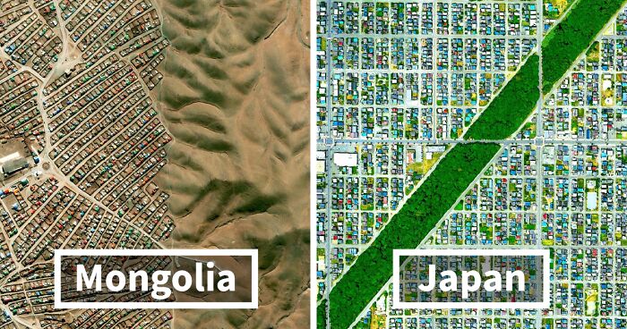
Arvaikheer is town in Mongolia accommodating 30,000 residents. It is the capital of the Övörkhangai Province, and is located in the middle of Mongolia’s 1,5 million sqkm of land. Foremost, the town is known for its traditional art, animal husbandry and equestrian sports. Yearly regional horse festivals are held to celebrate its long history of famous racing horses (dating back to the 18th century). In Mongolia, we find Land use plans at three different levels; National, Provincial and Local. Firstly, the National Land Management Plan covers the entire country of Mongolia and reflect the strategic planning 20 years ahead. Its mission is to develop a plan that is reasonable in its use for development, sustainable conservation and protection of the country. It also shall ensure that it works towards enhanced living standards for its citizens and grow the national economy. ⠀ ⠀
Secondly, the Provincial and Capital City Land Use Plans covers the province with focus on the provincial capital. The plans are required to follow to the National Land Management Plan, and must reflect the environmental issues and matters relating to the protection of the land. This plan reflects the strategic planning 12 - 15 years ahead.⠀
Finally, the Sub-county Land Use Plans is a detailed plan dealing with the immediate land management and development matters within the sub-county. The plan is required to follow the National and the Provincial Plan, and is created every year.
So desolate looking, I guess I'm just used to lots and Lots of green and trees.
Where are the horses? I don't see any space for horses. If they wanted to show us horses, they could have shown us a different area of this city.
The horses are with the true Mongolians in the hills that move with their animals and live in Yurts
Load More Replies...Joanna Trotter of the Metropolitan Planning Council also spoke with NatGeo about the dip in population in Gary, Indiana, due to poor city planning.
“Gary, Indiana, was originally planned for 200,000 people. The closest the city ever got to that number was in 1950 when it had 178,320 people. Today, Gary has 80,000 people—less than it did in 1930.”
Park La Brea is a large housing complex located in LA. It has a total of 4,247 apartments divided into eighteen 13-floor tall towers and thirty one 2-floor tall garden townhouses, making it is the largest housing development west of Mississippi. The townhouses were designed in 1941, while the iconic X-shaped towers were designed in 1948, inspired by Le Corbusier with shared green space for the residents. In the photo we see a few of the X-shaped buildings and townhouses.
I can't decide if I like this or not, but at least there are a good amount of trees.
It seems like at least some thought went into functionality for real people, rather than an architect imposing his opinion about how people should want to live on the development.
Load More Replies...Toledo used to be the capital of the Spanish Empire before the middle of the 16th century. It has an extensive cultural and monumental heritage, and has been ruled by different groups of Christians, Muslims and Jewish cultures. The streets in the Old Town are winding and cobbled and often filled with locals and tourists, as well as a great number of vehicles (which do somehow find their way through the city).
The olives are obviously not grown in the city, I don't see the trees.
Load More Replies...needs more trees. I know Spain cut down 99% of their trees when they built their failed Armada against England but they're had plenty of time to replant.
The cathedral in Toledo is amazing, and totally worth the visit. The Jewish temple is much, much less grand, but is wonderful and serene...
agree, but there is no space. the old town is very small and full of historical buildings. There are plenty of parks around it. And it is surrounded by a river. paseo-glob...x392-2.jpg 
agree, but there is no space. the old town is very small and full of historical buildings. There are plenty of parks around it. And it is surrounded by a river. paseo-glob...x392-1.jpg 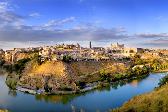
Antigua is one of the six Municipalities of Spain belonging to Canary Island Fuerteventura, and is one of the oldest municipality on the island. In the 19th century the town (also municipality) used to be the capital, but this title has been taken by Puerto del Rosario since. A windmill and some mansions are testimony to the former importance of the place. Particularly striking is the blue and white Art Nouveau villa from the period around 1900. This picture shows residential and resorts within the Fuerteventura, Castillo Caleta de Fuste located a few hundred meters from the sea.
Regarding Gary’s future, Trotter is likewise focused on long-term growth. Her ultimate goal for the city is a potential industrial boom.
“Planning includes better housing and transportation, as well as parks and rivers that are clean and available for use by the public.
“We are preparing Gary not for growth, but for stabilization. We were working with the city to find projects that will attract businesses and strengthen the urban core.”
Buenos Aires, founded 1536, is a city with a grid-pattern. Charles Darwin once describes the grid structure quite remarkably. He explained that Buenos Aires was "one of the most regular [cities] in the world. Every street is at right angles to the one it crosses, and the parallel ones being equidistant, the houses are collected into solid squares of equal dimensions, which are called quadras."
I would love to visit Buenos Aires one day. But maybe not while the Wolverine wannabe is in charge.
"City Planners Made Incredibly Thought-Out Decisions In Urban Design'? A grid pattern of square city blocks? By what definition is that 'incredibly thought out'? How much brain-power did that take?
It's so incredibly big! If you arrive by plane, all you see is city in all directions.
Foster City is a planned city located in California. The city has been ranked as one of top towns to live well and best places to live by Forbes and Money magazine. Foster City was founded in the 1960s on a landfill in the marshes of the San Francisco Bay. When we compare the original 1961 Plan for Foster City to the city it is today, we see a plan which is well conceived and well implemented. The land area of the city is still the same, likewise with the configuration of the "Venice-like" Lagoon system which formed the backbone of the plan, the major roadway network, the land use configurations and major public facilities. Foster city is said to be a successful urban planning project which, already in 1958, pioneered many planning and urban design standards we value today in good placemaking and sustainability.
Sounds cheep especially if you are on the water - https://www.realtor.com/realestateandhomes-search/Foster-City_CA/beds-3-3
Load More Replies...Having lived there for 8 years in an apartment, the best part are the bike paths that go around the whole development on the water. I highly recommended bringing your bikes and go for an hour ride. You can also go all the way up North to SFO - check it out on google maps - good restaurants and great and 'cool' location on the bay - perfect climate.
Yeah, living on what was once marshland sounds like it would not be good when it comes to earthquakes or rising water levels because of the climate.
Load More Replies...Lincoln park established in 1867 is a park in the center of the urban Washington DC. Pierre L'Enfant, the French-American, behind the design of the streets in Washington DC, or known as the L'Enfant Plan, included Lincoln Park in the original plan of 1791. In L'Enfant's Plan, most streets would be part of a grid system. Some streets had an east-west direction, and others north-south direction. The diagonal avenues which intersected with the north-south and east-west streets in circles and rectangular plazas were later places where notable Americans were honoured and provides an open space for the general public.⠀ ⠀
In the top you can see the road leading up to the neoclassical white-styled Capitol Hill.
The big crisis with DC's urban planning is that everything funneled into Pennsylvania Avenue, which would have been called "Main Street" in any other American city... and then after the Oklahoma city bombings and 9-11, they progressively shut down Penn near the White House and Capitol for fear of truck bombs. Long before that even, the White House was surrounded by a square, and the Capitol by a traffic circle.
Not so much funneled in, but funneled out. He planned a way for the resident on Pennsylvania Ave. (The president) Could get out from any direction quickly, while potential invaders would get lost or walk in circles for long enough for the president to be long gone
Load More Replies...LOL I was just complaining about the annoying layout. All the circles and avenues mess up the square grid system and make it easy to get lost. I've lived here all my life and still forget sometimes!
I actually like how DC is laid out and how the streets are named in order by alphabet or numerals.
Load More Replies...And the conspiracy crazies want you to believe that it is laid out in Masonic symbols.
Other U.S. cities make it easier for their residents who prefer sustainable living. Chicago’s Sustainable Development Division provides aid and assistance for those who want to grow plants and fish in mini greenhouses called “hoop houses.”
Division head Kathy Dickhut recognizes the importance of these structures, especially when growing crops under the city’s weather pattern.
“In hoop houses, crops like kale can be grown 10 months out of the year, even in a Chicago climate.”
Wemding is a town and municipality with about 6000 inhabitants. The town is perhaps most known for the Zeitpyramide, a public artwork started in the early 90s and is scheduled completed in the year 3183. However, the historic town center is worth mentioning for having been declared a historic monument and was kept protected thanks to the circular town walls we see in this image. In the middle we see a marketplace together with the middle-class houses. The town has been referred to as the town of the fuchsias as the botanist Dr. Leonhart Fuchs was born and raised here. Therefore every year for two days the marketplace is filled with plants and scents, and a fuchsias pyramid is built with 1.000 fuchsias. This year the event was cancelled due to COVID-19, but will take place 29th – 30th May 2021. Quite a spectacular sight if you happen to be in the area.
This thread is three years old, going by the date in this description. BP is a master of recycling old stuff.
Sun Lakes is a master-planned community developed around the mid 70s by a single builder, Robson Communities. The Sun Lakes Resort was created for retired citizens to provide excellent and relaxing surroundings. In the area you find 10,000 homes, five golf courses, five country clubs, two shopping centers and a medical and education center.
Powered by AC, surrounded by fake greenery in a desert.
Load More Replies...Note the demographics, median age 69, 98.4% white. Total illogical use of desert lands, green golf courses, lawns, and lakes, all as artificial as the people who live there.
While I 100% agree about land use in the desert, what do you mean about the people being artificial?
Load More Replies...Move to Arizona and die - you're already in hell, so no need to worry!
Of course it is. This is Arizona! Greater Phoenix has 200 golf courses in the middle of the stinkin' desert.
Load More Replies...and massive humidity and wasted water for golf courses... depriving the desert of it's millions of years of aquifer water - such massive waste.
Today we are sharing one of our favourite photos. Elche is one of the 20 largest cities in Spain. It is the successor of La Alcudia which Greeks, Carthaginians and Romans had in possession at a time. Elche lost its some of its importance when it was moved from the sea, but became important for its traditional footwear industry when the railway was introduced. The "Palmeral of Elche" is an UNESCO World Heritage for its over 200.000 palm trees.
Have you read properly? The Palmeral is an immense palm tree forest and there's a garden in Elche called "El Huerto del Cura" which is one of the most beautiful ones in Spain. lack of trees?? Come on😉 https://visitaelche.com/wp-content/uploads/2023/04/Huerto-del-Cura-1.webp
Load More Replies...This looks, and bear with me because it's a weird metaphor, like "two parallel lines to a given line through the same point" diagram from introductory textbook of hyperbolic geometry.
Here from the city of Vigo in Spain, a country which has an abundance of plazas. We see the mid-rise residential areas circling around the plaza. The square is currently an only pedestrian square. It was paved and got a playground, including the historical monument that was sculpted by Julio Gonzalez Pola. The square's large size makes it ideal for walking, relaxing or sunbathing. If you visit make sure to look at the architecture as it has an interesting architectural heritage spanning from the nineteenth century to the first part of the twentieth.
La Plata was founded in 1882 and is a planned city. Grand schemes of planned cities were popular in the late 19th century. The city was designed in a very strict grid-pattern form, and with many avenues and diagonals. ⠀ ⠀
The center is named Plaza Moreno and is the heart of the city where both the city hall and the cathedral is located. The city is very green and is an example of a hygienic city that became very important with the industrialisation.
Pointe-Noire, the second biggest city in the Republic of the Congo and national commercial centre, has about 1 million inhabitants. An important urban concern in the country is that new suburbs are being developed without any planning permits given by any governmental authority or local urban planning authorities. The suburbs are being created ad-hoc, and has resulted in massive sprawl. The developments being carried out are products of unplanned urban development. Despite being unplanned, they do not have characteristics of slums or informal settlements. However, the unplanned areas are lacking local infrastructure such as schools, recreational spaces, playgrounds, inroad and pipe networks.
This looks pretty well planned out. Complete with lots of trees. But that traffic circle (junction) at the bottom looks hellish.
The park opened in 1992 with the aim of becoming an iconic place in Madrid as the city was named the European Cultural Capital. The park consist of recreational, leisure and cultural areas. In the 220 hectares of land there is a 30.000 m2 lake, 1,9 km long river, 13 km with paths, 21 hectares olive groves, 19 sculptures, a garden, and a auditorium. No doubt, it's huge! Before the municipality of Madrid created the park it was a waste ground used as a refuse dump. The bad soil conditions were there but this was didn't stop them. However, one area with olive trees had miraculously survived (Olivar de la Hinojosa) even though the olive grove was nearly deteriorated. Many of these beautiful, over hundred year old, olive trees were taken care of and treated to be used in the park.
St Vincent Gardens is located in Albert park in Melbourne, and is a park of national significance. The park created in the 1850s is a great example of residential development around a landscaped square. It takes the form of a large rectangular area with semi-sircular crescents at both ends and has a tram passage between. Some say the development of this area is one of Australia's best town planning examples, which surely can be discussed further. But no doubt, it is a great resudential area. The aesthetic, historical, architectural and social significance made St Vincent Gardens registered in the National Trust of Australia and the Victorian Heritage register. Today it is a attractive place for having weddings, going for a walk or just playing in the park.
Patterson Park was established in 1827 and donated by William Patterson, businessman and founder of the Baltimore and Ohio railroad, to the city for a public walk. The city bought more of his land in 1860 to expand the park. Today it is about 137 acres (0,5 km2). As you can see in the photo, the park has many attractions, large trees, paved walkways, athletic fields, playgrounds, swimming pool and more. A lovely park to take a stroll on a sunday afternoon.
For a short time I lived across the street from this park. No trees outside of the park. Just rows and rows of row houses
Charles de Gaulle is the 2nd busiest airport in Europe after London Heathrow, and 8th busiest in the world. The airport has 3 terminals, and terminal 1 (as shown in the photo) was designed by Paul Andreu in the shape of an octopus. Andreu hoped to build other terminals based on the design of terminal 1, but several defects were identified few years after opening the airport in the 1980s and its design has been criticised numerously. Paul Andreu has also designed airports in Manilla, Jakarta, Shanghai, Abu Dhabi, Dubai, Cairo, Brunei and Paris.
Not keen on CDG. Might look nice from the air but that's not all you want from an airport!
Yep. It must be hell to take off on a curved runway. 🤭😆
Load More Replies...In the end of the 17th century Avola (like Messina) was struck by an earthquake that destroyed the city. The city was rebuilt once more as a baroque city in a hexagonal form, as designed by Monk and Architect Angelo Italia, which is still present today (as seen in the photo). It has striking similarities to the hexagonal city of Grammichelle, just 80 kilometres away.
For some reason, i think it would be easy to establish a fort there in the event of a zombie apocalypse
The municipality of Maricá is a growing community located east of Rio de Janeiro. The municipality is divided into four districts: Maricá (city), Ponta Negra, Inoã and Itaipuaçu. (Itaipuaçu district pictured). The municipality is known for its beautiful and peaceful atmosphere and landscapes. However, the city core of Rio de Janeiro can be reached within an hour. Many of the properties located by the seaside are used short-term or by tourists, while the ones further away from the sea are used by residents.
Sveti Stefan, which used to be an island and fishing village, is a small islet and luxurious 5-star hotel resort in Montenegro. The fishermen cottages, stone houses and red tiled roofs (traditional in Montenegro) from the past have been preserved. After Montenegro’s independence in 2006, the government searched for someone who could restore the island to its former glory. Aman Resorts were awarded this privilege due to their exclusivity and extraordinary portfolio. The resort has 50 rooms, cottages, and suites on the islet.
Shuangyu Island, knows as the Double Fish Island due to its shape, is an artificial island currently under construction just south of Xiamen. The architectural design was inspired by a pair of dolphins circling around each other. The island’s size is approximately 2.2 km2 (540 acres) with a 11.4 km coastline, and has been planned as a high-end ecological resort featuring lifestyle, leisure, health and tourism activities.
Next thing, you'll tell me Killer Whales are not whales. Oops - "Orcas are the largest species in the dolphin family." (like Fish ;-) ?
Load More Replies...What about it? Many places have reclaimed land from the sea.
Load More Replies...Bexley is a borough located east of London, with modern development dating back to the 19th century. Bexley’s urban development pattern can generally be divided into two areas. One area is the predominantly older estate villages, while the other area is more urban infill areas with suburban houses and centres. ⠀ ⠀
The borough is designated as one of the ‘opportunity areas’ in The London Plan. The opportunities seen within Bexley include the further development of logistics and industrial/green enterprise development.
Nobody's gonna complain that all the houses look the same? Or is criticism reserved for American cities only here on BP.
I checked the original post. This is an aerial view of Bexleyheath, viewed with West (not North) at the top. It's not an exciting place, but it's not filled with identical houses either. It's just that almost all of them have red tiled roofs. Have a look on Google Streetview - there's a distinctive park in the bottom left quadrant, centred here: https://www.google.co.uk/maps/place/51%C2%B028'09.9%22N+0%C2%B008'19.4%22E/@51.4694276,0.1361434,17z/
Load More Replies...Aiete, is a quiet neighbourhood located the heart of the village of Donostia (also more commonly known as San Sebastian). The terraced apartments surrounding this area are built on a sloping hill and create a beautiful neighbourhood with a community feeling. Furthermore the inhabitants have green space right outside their doors (including the huge Aiete park nearby).
That big green area looks like a large football/soccer field given the markings and size.
Load More Replies...Hamedan is believed to be among the oldest Iranian cities dating back earlier than 1100 BC, and also being the capital city at one point. The city is located more than 1,800 meters above sea level and has green mountainous surroundings. Hamedan city is circular and is formed by Imam Khomeini square (or Hamedan Square as seen in the middle of the photo), the square where six main streets of the city meet. The square as we see it today was created based on a hexagram shape in 1928, designed by German planners and architects.
Sadly, the Iranians tried to reinvent the wheel. Otherwise, they'd be stuck driving in circles for hours.
Load More Replies...Pasay is one of the main cities in Manila Metropolitan Area. This city quickly became an urban town and grew rapidly since the American Colonial period. In this photo we see the difference in housing between people living in more dense and hardscape areas (Villamor district) compared to the green and more lush open areas on the other side of the river (Magallanes district). We need to understand and push forward the implementation of green and sustainable policies for poverty reduction, job creation and green neighbourhoods to counter these issues!
Single-use plastics are a major problem in the Philippines too, clogging urban waterways, exacerbating flooding and polluting the seas. The Pasig River has made a huge comeback but there is still so much more to do. This is one area where relatively simple changes can have an almost immediate impact.
Yes, let's cross the river and tell me you are richer without telling me you are richer. The house sizes are pretty telling.
The banana-shaped Banana Island Resort in Doha (Qatar) opened January 2015 and has been delivering a genuine expression of pure Arabian elegance based on the Maldivian model. The resort is located 3,5 kilometres east from Hamad International Airport on a 30 acre manmade island. Building started in 2012 but missed several already announced opening deadlines in 2013 and 2014, before it finally opened in 2015. The resort has a luxurious hotel with 141 rooms available, and 45 of these are poolside villas and Maldivian types of villas located on the water.⠀ ⠀
"we've run out of land to build for the rich, let's just make some land"
You rather live with your camel in the desert in a tent? Got it. LOL. Ever hear of the Palms Island in Dubai and other artificial islands? https://en.wikipedia.org/wiki/Palm_Islands
Load More Replies...Marrakesh, founded around 1070, is the fourth largest city in Morocco. Marrakesh, like other Moroccan cities, consist of an old city filled with street vendors located inside a wall made of pisé (red/pink clay). Outside the walls you find modern areas bordering to the old city. The old city became an UNESCO World Heritage Site in 1985 because of its impressive number of masterpieces of architecture and art, and outstanding example of a living historic town with its tangle of lanes, its houses, souks (markets), fondouks, artisanal activities, traditional trades and more. The tourism to Morocco has increased a lot the last decades as the government has stressed the importance tourism repeatedly.
If you have been there, you will realise this was not planned, it just happened. So many tiny streets and alleys leading nowhere. A nightmare for unwary tourists.
It does look too haphazardly to have been planned.
Load More Replies...Songdo City is a planned 'smart city' built on 6 sq.km of artificial land just 35 km west of Seoul, South Korea's Capital City. Songdo is one of South Korea's answers to the urban development of business district like the ones in Dubai and Shanghai. It is moreover one of the largest private real estate development ever done in history. The city includes high-rise buildings, architectural hallmarks such as a copy of the Central Park and Venice's waterway, 40% green area, bike and walking paths. It is a smart city due to its tunnel vacuum waste system (and thus no trash trucks are seen), complies to LEED requirements, gets its energy from a local heating facility, and places emphasis on alternative transportation to privatised vehicular movement. The city is an example of an Low-Carbon Green Growth city, as introduced by the former president Lee Myung Bak who saw a need for more sustainable development across the entire country.
Those are apartment building for the most part - not business towers, though I'm sure they are coming or there already. What is "energy from a local heating facility - Oh, geothermal". https://en.wikipedia.org/wiki/Songdo
Load More Replies...Siheung City has almost 500.000 inhabitants and is located northwest in the peninsula of South Korea. In the picture we see blue aluminium roofs spread over a vast area with industrial buildings. Traditionally colors have played a significant role in Korean history, and was often a indication for social status. Blue tile was a sign of high social status. Many got similar blue tiles for their roofs as part of the New Village Movement in the 1970s (modernisation of the rural area) initiated by the president. Today even the presidential residence completed in 1991, named blue house, has blue tiles.
Rotanda West is planned circular-shaped community which came about the early 1970s. It is located by the Gulf of Mexico and has more than 8,000 plots for housing. This area, much like Sun Lakes in Arizona, is a place made as a relaxing area to residents who want to live in peaceful and green areas. However, it has received criticism for being a closed and gated community only serving one type of people.
Move to Miami! I bet there are very few Progressives there too.
Load More Replies...I bet crime is low, lots of golfers, and water lovers. Hmmm, I wonder who that appeals to vs diverse Miami. I wonder how diverse Tokyo is - LOL - Tokyo is overwhelmingly a mono-racial society with 98% of the population being Japanese, and the remaining 2% being Korean, Chinese, Philippine, British, American, Brazilian, and Peruvian.
Frisco is a city with a land area of 62.4 sq.mi (161.6 sqkm), and 200,000 inhabitants. From 2000 to 2009 Frisco was the fastest growing city in the United States. Just 30 years back in 1990, there were only 6.000 people living in the city (194k increase). In 1904 the town was named Frisco city in honor of St. Louis–San Francisco Railway on which the town was founded.
Immediately to the East is an elementary school; the traffic loop is even slightly visible. A few blocks further to the East and South is a plaza featuring a permanent indoor farmer's market. To the Southwest is a WalMart SuperCenter. But surprisingly for such a large city, no bus service. Most American cities that size have bus service. (There is free shuttle service to the elderly and disabled.)
Load More Replies...The urban form of Chiang Mai (from Thai meaning: New City) is quite interesting. Chiang Mai was established in the 13th century as the capital of an area consisting of today's southern China and northern Thailand. The historic center of Chiang Mai was walled and nearly a perfect square, in accordance to principles of feng shui. There used to be five gates surrounding the city, and outside the walled city where there is a lake where one believes rice farming took place. The city has been influenced by Chinese capital city planning standards as the palace and religious centre is towards the north wall, in the centre of the north-south direction. However, except for some main streets which connects to the gates, the standards for a Chinese capital city is not based on a grid design.
Pantin Cementary (pictured) is one of the Parisian cemeteries located northeast of Paris. However the oldest garden and municipal cementary is Père Lachaise Cemetery. It was established in 1804, and is the largest cemetery located in the urban Paris (110 acres). It was named after the confessor to Louis XIV, Père François de la Chaise. The famous architect Alexandre-Thęodore Brogniart created the layout for the cemetery as requested by Napoleon Bonaparte.
I mean, a cemetery CAN be called a "city of the dead" (necropolis)...
Load More Replies...Pete Lachaise cemetery is not the oldest in Paris. It’s still considered ‘new’ compared to the other famous Parisian cemeteries. Fact, the first person buried in Lachaise, was a five year old girl named Adelaide de Villeneuve.
Edku is a city located 42km north-east of Alexandria along the Mediterranean Sea that houses about 100,000 inhabitants. The primary industries within the area includes energy (LNG plant), rice milling and silk weaving industries.⠀ ⠀ Here from Edku town, an urban form similar to that of the old town (Medina) in Marrakech (Morocco).
Cárdenas, founded in 1828, is a city and municipality in Cuba located 140km east of Havana (Cuba’s capital). The city was designed and inspired by the American grid pattern, and not the traditional Spanish central plaza typically found in most Cuban cities. However, most of the streets have a narrow form. The city was one of the first cities in the country to have electric service, public transportation (trams, since 1913), telegraph and telephone.
how can you tell from that high up? Maybe there are smaller green spaces? Not every city needs a central park sized green oasis.
Load More Replies...Durrat Al Arus is a gated tourist town built on a manmade island in 1996. It was designed to be an integrated holiday home city with all forms of leisure activities including retail, F&B, cafes, resorts, hotels, private villas, theme parks, aqua parks, yacht marina, equestrian club and golf club. Although a lot was built and still operating, most of the facilities have either closed down, been abandoned or sold to private investors. The town is considered to be very liberal and open-minded. Quite the opposite from typical Saudi Arabian culture and traditions.
The Saudis do seem to have a way of wanking a load of money on things only for them to be completely undesirable and impractical.
What is lacking in these typical American sprawl developments? The fail of considering climate change and public health. For planners this is of great importance as cities - for decades - have planned in a way which made people sit down in their cars, houses and offices without moving much in between. This has changed our health for the worse. This is caused by many factors, but definitely the combination of cars and cheap fuel which created the urban sprawl. ⠀ ⠀ Studies of life expectancy in cities and urban sprawl/rural areas have found that those living in city centers may often have a longer life expectancy than those living in the outside areas, due to their more active lifestyle and higher use of public transportation.
Yes, lets build for all of these "water-needing" people in a place that doesn't have a lot of water to begin with.
Lousy example for what is being criticized. That major route up the middle provides heavy commerce within walking distance of any homes in the squares. The center-left square is probably the least-valued housing, but is centered around what appears to be a school, with tennis courts and a swimming pool. Really, the only thing "wrong" is why are people moving to desert states like Arizona, when there is so much largely empty land in states like Tennessee, North Carolina, Missouri, etc. If I would improve this, it would be to add some pedestrian "short cuts" to better access the commercial buildings along the central artery.
The corporate headquarters of Apple is named the Apple Park. It opened in 2017 and accommodates more than 12,000 employees within the 318,000 sqm office and laboratory space (80% of the campus is green space). However, it has more than 14,200 parking spaces covering an area of 325,000 sqm. Cupertino Parking Regulations required 11,000 parking spaces, while Apple provided 22% more parking than required. Apple Park has been heavily criticised for contributing to urban sprawl and car-dependency. Fortunately, Apple provides buses to the campus and offer bicycles to get around in the campus, and neighbours have seen an property value increase.
"Apple Park has been heavily criticised for contributing to urban sprawl and car-dependency." It's too bad, Apple has not left to Texas, yet taking its jobs and taxes with it like Tesla. Then the stupid writer would be complaining about the lack of jobs and urban decay. Gotta love dumb Progressives.
King Abdullah Sports Stadium located in Jeddah has combined traditional islamic architecture and innovative design to create a flexible, sustainable and functional stadium accommodating 60,000 seats (the largest stadium in the country). Beside the stadium other facilities such as a 10,000 seat indoor multipurpose hall, 1,000 seat outdoor athletics track and stadium, 4 normal-sized football fields and 4 small-sized football fields, 6 tennis courts and athletics facilities. Perhaps the most surprising number is the 23,000 parking spaces spread over a land area of 3 sq.km. In comparison, what is claimed to be, the largest parking lot in the world is located in Canada as part of the West Edmonton Mall, and accommodates 30,000 parking spaces.
Jumeirah Village Circle (JVC) is a master development by Nakheel launched in 2005, it is built over an area of over 8.7 sq.km. The development is divided into 6 main districts separated by green space and radial roads from the centre of the development. JVC consist of Villas, Townhouses, Apartments, Offices, Commercial/Retail/F&B and Hotel Serviced Apartments. While it is one of the few developments in Dubai with an overall open space network, there are limited job opportunities within JVC requiring most people to travel by car. Currently, there is also limited and unattractive public transport.
Any city without good public transport is an instant no from me. It shows an utter lack of imagination.
Come move to LA or NYC! Get mugged on public transportation, sit next to mentally ill drunk homeless, and so much more!
Load More Replies...It’s in the middle of the desert… it’s not meant to be green.
Load More Replies...This is among the cooler listicles for sure. When thinking about it ... a circle around the innermost part, diameter like 1...2 km, radial main roads from there, about 6, a few more rings, and fill the gaps with rectangular grid - and from there, let it grow itself. Reserve some space for forests or parks, accomodate the buildings and infrastructure to the landscape and bodies of water you find, not the other way, and integrate a subway system right from the beginning. Would be a rough description of the approach I consider most promising, but, of course, large urban structures are subject to development and to a somewhat organic growth and shrinkery - we just set a starting equipment and setup, but how it turns out in the long term, is ... forseeable, somewhat so, but not total, and too tight a planning may ruin many great ideas, so that ain't to be!
Really cool article BP! Interesting to see which cities grew and which ones were planned. I would like to nominate Budapest, particularly District 8 and 5. 5 is the row housing with a fairly distinct building style, and District eight is filled with industrial buildings and disused rail lines, along with the Soviet commie blocs from that era
I think that the critics here couldn't plan a birthday party. They are SO annoying.
It would not look like much from above, but the town I grew up in was a planned community. It was broken up into sections (Parks) such that no child ever had to cross a major street to get to elementary school. No more than one major street to get to middle school, and no more than two to get to the high school. This was many years ago, but almost nobody drove to my school back then, as the town was so walkable...
This is among the cooler listicles for sure. When thinking about it ... a circle around the innermost part, diameter like 1...2 km, radial main roads from there, about 6, a few more rings, and fill the gaps with rectangular grid - and from there, let it grow itself. Reserve some space for forests or parks, accomodate the buildings and infrastructure to the landscape and bodies of water you find, not the other way, and integrate a subway system right from the beginning. Would be a rough description of the approach I consider most promising, but, of course, large urban structures are subject to development and to a somewhat organic growth and shrinkery - we just set a starting equipment and setup, but how it turns out in the long term, is ... forseeable, somewhat so, but not total, and too tight a planning may ruin many great ideas, so that ain't to be!
Really cool article BP! Interesting to see which cities grew and which ones were planned. I would like to nominate Budapest, particularly District 8 and 5. 5 is the row housing with a fairly distinct building style, and District eight is filled with industrial buildings and disused rail lines, along with the Soviet commie blocs from that era
I think that the critics here couldn't plan a birthday party. They are SO annoying.
It would not look like much from above, but the town I grew up in was a planned community. It was broken up into sections (Parks) such that no child ever had to cross a major street to get to elementary school. No more than one major street to get to middle school, and no more than two to get to the high school. This was many years ago, but almost nobody drove to my school back then, as the town was so walkable...


 No fees, cancel anytime


")
")


")
")