Get Premium
Dark mode theme is available exclusively for premium users. Learn more about the benefits of subscribing.
No fees, cancel anytime.

 Dark Mode Ad-Free Browsing Unlimited Content
 Ad-Free Browsing Unlimited Content Dark Mode
Join 1.2 million Panda readers who get the best art, memes, and fun stories every week!

There’s a wonderful online community on Reddit that’s dedicated to beautiful, intriguing, and artistic maps that will wow you and make you see the world from a whole other perspective. As someone who loves doodling maps in my spare time, I’m in heaven. And even though our generous and benevolent social media overlords [cough cough] don’t allow us to mention the full name of the subreddit because of one particular word that it uses, make sure you visit the group, check out their latest maps, and maybe even become members yourselves, dear Pandas!
In the meantime, let’s enjoy some gorgeous and interesting maps, shall we? Remember to upvote your fave pics as you continue scrolling. In need of an extra mega map fix? You’ll find Bored Panda’s previous posts about the ‘Map [Whoops Can’t Mention That Word Here Anymore]’ community right here, as well as here.
We reached out to the founder and moderator of the subreddit, Patrick McGranaghan. He told Bored Panda all about how his passion for maps was first sparked, as well as how amateur cartographers can develop their sense of style and design to create better maps and do their imaginations justice.
More info: Reddit | Twitter | Tumblr
This post may include affiliate links.
That’s awesome! Also, you should totally visit Washington. There are many excellent places to hike.
Oh yes, it completely changes my perspective on things to see a map of the state's which a stranger has visited. Clickbait BP at it again.
You should add dates , it will mean a lot later in your marriage to look back on these
That's wonderful. It's so nice to see animal or bird populations increase like that. Thank you to all the conservationists who are making that happen.
My stupid brain said "why are the following the state line?" before realizing that it's a river
@Bill: Perhaps for humans, but for birds of prey it was not a „scare“. The effects were real and significant.
Load More Replies...In the early 70's, we used to fish at a lake in N.W. Wisconsin that had a bald eagle's nest. It was a huge deal at the time. I now live in Minneapolis and seeing a bald eagle is probably a weekly event. So great to see them bounce back.
Now if hunters would do three things: 1) used copper shot 2) track what they shoot 3) be better shots there would be even higher numbers. Lead poisoning is a terrible thing to see in a Bald Eagle or any raptor who eats carrion. And think of the suffering of the animal hunters shoot w/o tracking. Shame.
FYI, the Trump sdministration rolled back any of the Clean Water Act protections. Also, the Clean Water Act was originally instituted by Republicans, they used to be far more progressive than they are today. Now they are assaulting clean water and air. One source: https://www.politico.com/news/2020/01/23/trump-epa-curbs-water-protections-102779
My brain is seriously hurting after this one the illusion is crazy.
"I developed my passion for maps very early. My family traveled and moved around a lot. My dad taught me how to read maps and I would help him navigate. I used to flip through our Rand McNally atlas to pass hours traveling across the countryside. Maps are invitations to explore and visit new places. They give security in the knowledge that there's a way to get to your destination. If all else fails, a map will be your guide," Patrick shared how he first became acquainted with maps and how his passion grew. It hits close to home.
Patrick also reminisced about the moment he came up with the idea for the subreddit, back when he was living in a small flat in Taipei, in Taiwan. "I knew that I had a good idea and it felt almost electric. Like a fork in the road and your destiny is changing. When I moved back to the states I was able to find a career making maps (as a land surveyor) and I am grateful every day that I can do something that I love."
We dont have many railroads in the upper part of south america because we have a very mountainous geography so it is dangerous. Also we don't have proper highways because of the same reason. In europe and 800kms car travel takes about 8hrs here that same distance take us about 17hs.
Load More Replies...The outback and the Himalaya (Hindu Kush?) really are some of the most empty places left on earth
I agree with lapetos even though he has been heavily down voted so I probably will too. This map makes me kinda sad. An indicatiob of the humans invading the earth and destroying it. You should see how people would react if they would see a map of any other pest. (For instance of a building)
There is actually very little of the UK that is that flat. East Anglia is the flattest part of the country which is made up of the counties Suffolk, Norfolk and Essex where you get a diverse range of fens and marshlands and the beautiful beach used in the closing scene of Shakespeare in Love (Holkham Beach). East Anglia is the largest bulge outwards on the bottom right hand side.
Load More Replies...Northern Ireland is there so its the UK. Great Britain is just England,Scotland and Wales.
Load More Replies...Agreed. There's no perfect projection (I've asked someone with a degree in geography over in Europe who actually studied projections comparatively for a class), but the Mercator is.... a bit much-ish.
Load More Replies...This ! I'm so tired of Mercator projection and its Northern-biased view of the world. Do people still believe that Greenland is bigger than South America ? It's 9 times smaller. And Africa is much larger than North America. All countries of Europe fit in Brazil alone. And while it is still very large, Russia is in no way larger than Africa.
Some of us would need a magnifying glass for our countries to be seen! ☘ 😆
Load More Replies...Basically Africa, the Middle East and South America are the only ones not faking it.
Geodesy is the study of the shape and locations of things on the earth. The earth is a tri-axial oblate spheroid, not nice and round. Making maps can be done using a variety of projections from the center of the earth onto geometric surfaces that best fit the area to be mapped. Cylinders, cones, and flat planes. Mercator maps use a cylinder. Calculating where the position of a point on land will fall on a map surface is complicated. With todays computers and satellites, raw latitude and longitude are used rather than map coordinates to get around.
Doing what we love for a living is a godsend. And though everyone might be there, plenty of us have felt the 'electric' feeling that Patrick's talking about where genuine excitement meets the potential for greatness.
Even though a lot of the amateur cartographers found on the subreddit have great ideas and are overflowing with creativity, their execution needs work to make the end results look less "hasty and skeletal." Patrick explained that some people need to develop their tastes for style and design. Luckily, he had some helpful tips for you and me.
"It is not that they are bad, it's just that they don't know that they can make their maps so much better. I'm talking about things like fonts and information boxes, detail and vicinity maps, adding gradients to water features, thoughtful color choices, shadows behind place markers. The subtleties are what make maps exquisite," he detailed.
I like how the population is not just indicated with color, but also with how well-fed the depicted bears are.
None of them are looking happy but the ones in the southwest are very sad :'(
Load More Replies...i’m stalled out at the phrase ‘the glorious nation of finland’ which is a bit odd. i’m certain it’s my fault.
During the Dust Bowl in the US Midwest, President Roosevelt implemented a program to plant trees in rows as windbreaks to stop the wind from ripping up bare topsoil. The program worked well, and you can still see some of those trees standing today.
I hope many of them are still standing today. Most tree species are meant to live hundreds of years and it's sad to consider them disposable after "only" 80 years.
Load More Replies...In the Sahel slashing and burning of forest in order to clear land for agriculture is the cause of the creaping Sahara, Farmers continue to plant their crops until the soil is depleated. Then move on ... repeating over again.
Really hope this is happening. It has been talked about for decades and needed cross country agreements.
There's also the 'Dig it' initiative. The topsoil has become real hard, so even though it rains enough it is not getting in, so they are digging up places to get to better ground and making it green again
A few years ago, the entire country of Ethiopia took the one day off, and everyone went out and planted trees all over.
Or perhaps it’s just because Russia really is enormous. 😉
Load More Replies...I love this! My kids had a big globe night light when they were small! We would spin it at bedtime to decide where our bedtime story would take place.
"The best way to learn how to do these things is to look at lots maps and see how other cartographers solve these problems. Imitate the masters. Read a few books on cartography and design. Some of the books that influenced me are 'Info We Trust' by RJ Andrews, 'Cartography' by Kenneth Field, and 'Things Maps Don't Tell Us' by Armin Lobeck. If you can integrate the ideas in these books you'll be a league above the average amateur cartographer."
As for the future? Patrick's waiting for the Covid-19 pandemic to die down and go traveling again. Among his plans is visiting the Baltic countries, especially the Soviet map store in Latvia.
Can't tell but did they use a ☘ shamrock for Ireland (can't zoom in close enough 🙁) ?
It looks like maybe something similar that has five leaves and no stem—it really is hard to tell.
Load More Replies...You know it's not actually this artist or any OP putting these things on BP, right? Tip: click the grey source tag under a post to find out where it was originally posted/by whom.
Load More Replies...Lol at first I thought it was just saying that there were only two wolves left in 2020.
Glad they made a come back, some native wolf species elsewhere were driven to extinction.
In France they were no wolves left by 1930. Now there are hundreds (they're discreet and move a lot, it's difficult to count how many exactly) and yes, they came back on their own from Italy in the 1990's.
So where were all the wolves in the 70's? I know people wearing real fur was a pretty big trend back then but not sure if that's what was going on here...
I have heard of a mink coat, but I have never heard of a wolf coat.
Load More Replies...Then YT channel Out Of The Woods is for you! https://www.youtube.com/c/OutoftheWoods623 He feels Tennessee has the best timber in the world and after a few videos you'll tend to agree...
Load More Replies...It’s still being milled! Every time I drive from the coast inland I see lumber trucks and/or large bits of bark that have shaken loose in the road. It’s just so wrong! They’re the tallest trees on the planet and only cycads are older.
Load More Replies...With nearly 1.3 million members, the map-loving subreddit is a cartography powerhouse on the net (and it’s making me itch to start drawing a few maps of my own again). In June of 2020, the subreddit had just shy of a million members, so they're continuing to grow steadily.
The group has been on Reddit since the late spring of 2011 and will be looking forward to its 10th birthday in just a few short months. What with the rise and fall of online groups every single day, reaching the decade-long mark is no easy feat and it speaks to the quality of the content they share.
To anyone wondering about why it's just Indo-European languages depicted: This info-graphic is part of a comic set in post-apocalyptic Scandinavia. A pandemic has killed most humans (and other mammals, too) and turned surviving infected into zombie-like creatures. The survivors have turned back to their old gods and rely on mages and cats to guard them from the trolls and beasts roaming in the un-cleansed areas. Stand Still, Stay Silent: http://sssscomic.com
That sounds like a really interesting comic. Although you dont really need a reason to make a tree of only one language family.
Load More Replies...This is fascinating. I also love Hungarian out there all unique on its own.
As someone who comes from a family who speaks Assamese (seen above Bengali on the left), it was really cool to see it represented!
I speak Konkani and I was so happy to see it there too!! We love to see under-represented Indian languages :')
Load More Replies...I speak two germanic and one slavic language. I still need a "romance" one.
I speak one of each. Plus, an Altaic (?). Linguists still discuss it, but it does have connections.
Load More Replies...I love that your name uses three different diacritical marks!
Load More Replies...I wonder if there is a similar map of Spain with the Canary islands (that are always in a tiny square) being the focus of the map with the rest as a tiny drawing.
I love how the Hawaiian Islands are the same size as the continental U.S. Fun fact: Hawaii is the most remote place in the world in that it is farther from any other land mass than those landmasses are to anything else.
Well, mainland US did put Alaska as a footnote so this is fair. I wonder if Hawaii did the same?
Reminds me of the suggestion that as the Isle of Wight is the largest island exclusively in England it should be referred to as the English mainland.
The Cascades and Rockies have those as well as the Alaska range.
Load More Replies...I'd like to play the game that would go along with it. Reminds me of a cool strategy video game about Civil War I had some 30 years ago (yes I'm THAT old).
Alaska is not all snow you know... At least you didn't put in igloos. Native Canadians use them, not native Alaskans
In previous interviews with the founder of the subreddit, Patrick, Bored Panda learned all about the history of how the group was founded, as well as what kinds of maps you can expect to find. Patrick, a land surveyor from Colorado, founded the community while he was living in Taiwan in 2011.
A map geek through and through just like some of my colleagues and I, Patrick wanted to create a place where people could easily find and discuss beautiful maps. Patrick is also a member of the North American Cartographic Information Society, the Carles Close Society for the Study of Ordnance Survey Maps, the Rocky Mountain Map Society, among other groups.
So cool as a map, and not so cool if you think about the atrocious reality that was behind these maps at the very moment they were printed in the newspaper.
Load More Replies...When I was renovating my home I took down the old plaster to put up drywall and found they were insulated with some very well preserved newspapers. Front page headlines like "Hitler Appoints Henchmen" It was a amazing to me to read the ones from the 1930s-1940s in the perspective of real time, from the viewpoint of the people in my Canadian province. All I've ever know is the perspective on hindsight as I was born long after. I donated them all to my local museum and really hope someone gets the same wonderful gift of a new perspective they gave me. (I also learned from museum staff that my grandfather had donated some very cool things to the museum, he had passed a few years prior to my museum trip, and I had no idea, but he was certainly there with me that day.)
Always save the actual news stories after a big event. In five years, the story they will tell about it on the news and other places will be completely different.
That's because poachers can't follow them into the mountains very well.
Load More Replies...This explains a lot about that pollution map we saw at the beginning of the pandemic - Northern Italy is basically one huge pollution trapping high sided valley.
I’m going to have to look more closely later—it’s very early in the morning in California and I need to go back to sleep.
Load More Replies...This is from the comic "xkcd" by Randall Munroe: https://xkcd.com/1688/
I like how the comment at the bottom, second from the left, looks like a bus.
i think it all leads to "is it larger than a breadbox" lol also idk if this is right
According to the founder, there was a time not too long ago when the internet was much more chill about using certain words while naming online groups. “In the years since the culture on the internet has taken a much more puritan bias and some people don't like that name,” he explained and I can’t help but agree with him—you have to really watch what you write and say nowadays. And the internet sometimes seems like it doesn’t understand subtlety, sarcasm, irony, or jokes anymore.
It is always so confusing. I know that UK is NI plus Scotland, Wales and England but it gets really complicated. Are the isles of Man, Jersey and Guernsey considered countries or they depend on UK?
Guernsey and Jersey are British Crown Dependencies, and part of the British Isles. They are not part of the UK (although residents will sometimes add UK to the address on long distance postcards to make sure they reach home!).
Load More Replies...Yes, but you'll only make the confusion worse! Sometimes people use the shortened name Britain instead of Great Britain but mean the same thing, but really Britain does only really refer to England and Wales. The name Britain goes back to Roman times when they called England and Wales "Britannia" (or "Britannia Major", to distinguished from "Britannia Minor", ie Brittany in France). The Roman province of Britannia only covered the areas of modern England and Wales.
Load More Replies...Oh, this is a really dangerous map to post anywhere. 'British Isles' is not a term recognised by anyone from the Republic of Ireland. It can even be felt as a very offensive term when used to group these countries.
I gather they mean geographically speaking, they should have put that in brackets.
Load More Replies...The Channel Islands ARE part of the UK, not part of GB, it's a governance thing but this map is incorrect. Alderney and Sark should be within a Gurnsey oval, and the British Islands oval (which nobody uses or refers to) should be replaced by the UK one, someone's tried too hard to be clever here?
I lived in Almere (north of Amsterdam) for over a year. It has a beautiful forest area with a lot of wild animals. Its crazy because it looks super normal but its all created in the 70s. You can find sea sells in the forest.
Pssssst, just so you know, Almere is not north of Amsterdam. It's directly east.
Load More Replies...In Germany we say "God created the world and the Dutch created the Netherlands".
From this map, looks like the saying is very fitting
Load More Replies...Holland is one of the more fascinating lands... they fought the sea and "won"
Calling the Netherlands as "Holland" is like calling the USA as Texas.
Load More Replies...I will buy a beer for the first non Dutchie who can pronounce '-Gavenhage and 's-Hertogenbosch correctly.
I used to pass Den Bosch a lot and I will never learn how its supposed to be called.
Load More Replies...As the Dutch say "God created the World, but the Dutch created Holland". The Dutch government levies a poll tax on every citizen to maintain the sea defences, people who whinge about taxes should look at the map to see what would happen if they stopped paying.
Never heard anyone complain about those taxes though 😉
Load More Replies...Correction to the title needed. The above map is a map of what would be left of the Netherlands if the sea levels would rise 5 meters. Global warming and such. It's a warning of anything
I always thought that would put the beach near 's-Hertogenbosch (a.k.a. Den Bosch) 🤔
Load More Replies...The netherlands is sinking because the sea levels are rising, so this might be the future
I can assure you it won't. We're doing this since 1533 already
Load More Replies...Actually the correct term is not straight line but great circle, the shortest distance between two point on the surface of a sphere.
Obviously you are not familiar about 'shortest straight line distances. On a round globe, the shortest distances are always a curve, which follows the curvature of the planet. The line is Never straight. For instance flying from Seattle to Tokyo, is accomplished by curving northward to Alaska, and is why Anchorage Internation is always so busy.
Why not, but I can't imagine the time that would take. McAllen/Hidalgo County is 8 hours from Dallas!!! And almost 12 hours to Amarillo. & that's just TX!
Load More Replies...That's why a connection across the Bering Strait (between Russia and the U.S., Alaska) was a key element in the proposal of a global energy grid. Imagine solar energy being available 24 hrs a day. However; as this proposal was made in the 'cold war' era, the U.S. voted it down.
At first glance, I thought this was a redrawing of the equator. I would like to visit a world where the orientation of the globe was like this, where the pacific is much of the southern hemisphere, and an Arctic ice shelf lies on the Sahara, how different it would be.....
Well, to begin with, the Arctic and the Sahara wouldn’t even exist...
Load More Replies...Yes because of the eartlh's curve This happened also when I flew from Toronto to Hong Kong.
Time. Roads following that line? Complete lack of infrastructure for most part. Weather? Ground conditions in the far north? You'll need a boat at some point. Travel visas.
Load More Replies...Patrick explained to Bored Panda that there’s a bit of everything for everyone in the group: from historical and funny maps to imaginary and linguistic maps and more. “One of my favorite interactions is when a map is posted of an obscure place and someone in the comments says they live there or has a story about that place,” he said.
“Maps are a way to visualize the world in a way that is easy to grasp. They are an aid in learning about new lands and faraway places. They help us find our way when we are lost,” Patrick pointed out, adding that during the pandemic they can be great ways for us to travel while staying at home.
Am I the only one who wants to know about where to go pee? Anyone? Ok, then
I asked that question while visiting Carlsbad Caverns- Guide said they did have a few selected places in the cave system for that purpose!
Load More Replies...Would totally need a lot of mental fortitude to endure being underground so long
Wow - this blows my mind. I want to know how long people stay underground working there. It surely takes days just to get to the lowest work areas. I'm going to google this...
Aww, my university is too young to be on this map. It was founded as late as 1479.
I wonder what Oxford will do for its 1000th anniversary in 2096. I won't be here. Well, maybe, if I live to be 109.
How should one define a university to differentiate it from other communities of scholars?
Institutions of higher, or tertiary, education and research which awards academic degrees in various academic disciplines.
Load More Replies...Some of these stopped operating for hundreds of years and were later re-started
It is quite old! However there might be an issue with the "Continuous Operation" part due to some 18th-century hard-times for the University.
Load More Replies...I distinctly remember flocks and flocks of Flamingoes in Jamaica Bay in New York City as a child, seeing them from the train on the way to the Rockaways...
Plastic Flamingos are actually a product of a company called Union Products, which is not in Florida. People in Florida think they're tacky and (outside some specific snowbird neighborhoods in Miami) are a joke... Usually to piss off neighbors. Fun fact: the plastic flamingo is the official bird of Madison Wisconsin.
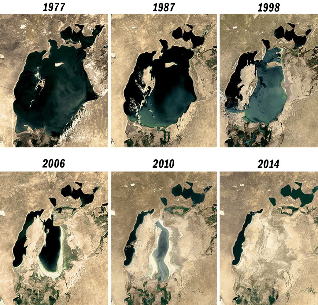
Load More Replies...Flamingos on Aral mer must be bummed. Soon there wont be enough water left to flush a loo
That little pink park of Mexico is the Yucatan. I have a home there. I've visited the flamingo nesting grounds a few times ... beautiful.
One of the categories on the subreddit is dedicated to political realignments that redraw borders and all I can say is that I’m a major fan. They’re imaginative, creative, funny, and make us look at history in an entirely different way. Playing ‘what if…’ games is a lot of fun.
Why do people love maps? Because they’re aesthetic. Because they’re like picture books for adults. Because you can get lost in them for days and they awaken your sleeping desire to go on an adventure. Because they reveal a novel way of looking at life that we’re not used to. And because squiggly lines are fun to draw. Or at least these are all the reasons why I love cartography (yours might be different).
I live in Portland, OR which sits on top of a volcano. Granted, it’s an inactive volcano but with the way the climate is going who knows what could happen. :p
Load More Replies...Olympus Mons is so heavy that if you dumped it onto Europe it would sink down to the Earths crust.
Do you think Mars just 'bled out'? It must have erupted for a 1000 years and covered the whole planet in an ash cloud.
Does anyone tilt their head and see it as a lizard chilling on a mossy rock?
True to its form then, mossy, boggy, stoney and vast
Load More Replies...Try thetruesize dot com. You can choose any country you'd like and drag it unto another country to compare their size.
Load More Replies...Wow--that's really interesting. Those projection maps are really misleading
Personally, I don’t mind that the map precedes the territory, no matter what Jean Baudrillard says. Why? Because, like unusual and intriguing books, they have ways of sparking new ideas and expanding our minds. Who needs the actual territory when we have such gorgeous maps to look at from the safety of our homes?
Inspired by the English countryside so hey it checks out
Load More Replies...Thankfully Alexis we didn't have to memorise counties! It would be the continents and countries of the world. A lot of study on physical landscape, natural hazards (weather, tectonic), urban issues and challenges, geographical skills (eg cartography). Though if you didn't know roughly were most counties were you'd look a right prat!
Load More Replies...You have top row showing Lancashire, and North Yorkshire and then under Lancashire are two white patches which are Merseyside and Greater Manchester. Staying on the left and under those is Cheshire, then under that is Shropshire which is above Herefordshire. Does that answer your question?
Load More Replies...Derbyshire, Gloucestershire, Hampshire, Lancashire, Leicestershire, Northamptonshire, Nottinghamshire, Warwickshire, Worcestershire and Yorkshire. Copy and paste, from Google.
Just a few missing (tut, tut Google!) and Yorkshire is more than one county (just to make it challenging!), so you have: North Yorkshire, East Riding of Yorkshire, South Yorkshire and West Yorkshire. Then also, Cheshire, Lincolnshire, Staffordshire, Shropshire, Herefordshire, Cambridgeshire, Hertfordshire, Bedfordshire, Buckinghamshire, Oxfordshire, Wiltshire and Berkshire. Devon used to be called Devonshire but it is now only used as a nickname. I think 🤞 that's all of them!
Load More Replies...The word shire derives from the Old English sćir, from the Proto-Germanic skizo (Old High German sćira), denoting an "official charge" a "district under a governor", and a "care". In UK usage, shire became synonymous with county, an administrative term introduced to England through the Norman Conquest, in A.D. 1066. In contemporary British usage, the word "counties" also refers to "shires", mainly in places, such as Shire Hall.
Ironically only two of the original 5 shires are coloured. The system was pioneered by the precursor kingdom Wessex, and spread to the rest of the country as the kings of Wessex became kings of England. Some modern counties represent entire early medieval kingdoms, such as Kent, Essex and Sussex.
Vatican City has the highest crime in the world in relation to the population. As in more crimes per person than any other country, due to the high number of crimes and small population.
I imagine that a lot of then are small theft due to the massive ammount of turists?
Load More Replies...I wonder where Vatican is on the list of countries with the highest proportion of green areas to built up areas.
Visited here 2 years ago. Could have spent a week there. WOW!!! the architecture, the antiques, the statuary, amazing place...
Which map was your favorite one and why? What’s the most aesthetic or interesting map you’ve ever seen in real life? Do you have any maps at home? Are you a major geek like me and love drawing maps for your Dungeons & Dragons groups (I hope I’m not alone!)? Share your thoughts and, hopefully, your love for maps in the comment section below.
Hawaii looks a little burned, but I bet it still tastes awesome!
In the UK it was called 'soccer' by the higher social classes, because football was the shortened form for 'rugby football'. Soccer was played by the working classes.
Load More Replies...If you go to a sokker match in South Afrika, you will encounter the mythical "Vuvuzela"
Argh!! Don't remind me! The 2010 World Cup! They became distinctly less mythical to many of us that year. 😉
Load More Replies...In fairness, in south africa most call it Ibhola which translates to "A Ball", which is a lot closer to football than soccer... but as soon as we start using english, we use soccer. I take offense that they used Afrikaans Sokker in this map which is understood by about 10% instead of zulu which is understood by more than 50% or xhosa with about 25%... even sotho/tswana is understood by more than 20%
Can anyone from Ireland confirm this map? On my vacation to Ireland a few years ago I've encountered the term Football, but not Soccer.
Irish person to the rescue!! Definitely Football. Not soccer unless you want to see a room (I mean pub) full of people cringe. Would put us off our Guinness!
Load More Replies...Well remember the term soccer came from the UK where it was a nickname for Association Football, as opposed to Ruby Football. In the 1860's the US went with called Association Football Soccer and Rugby Football as Football. The UK kept using both until the 1890's when they dropped Football from the name Rugby football. Though they did use Soccer as a nickname for Association football until the 1930's
It varies in Ireland whether we call it soccer or football. In my area anyway, when we talk about football we are usually referring to Gaelic football.
Load More Replies...So she rules them all in the North, your rule them all in the South I guess ?
As seen in "The Man in the high castle" an excellent Amazon Prime Series
It says "reservation", but yeah, I was going to say the same. Imagine who would live there, would there actually be space enough? We could never apologize enough to the First Nation people
Load More Replies...... Wasn't Japan part of the ALLIES in WW1 though? I'm pretty sure in 1914 they conquered and later annexed the former German Colonies in the Marshall Islands, the Carolines, the Marianas, the Palau Islands and the port of Tsingtau (now Qingdao, in China).
The German gave them California and the west coast looks like.
Load More Replies...You could ask this same question on so many other topics
Load More Replies...What I find interesting is that in Indonesia Sulawesi decided to go it alone—why, I wonder.
Notice there are no pink regions. That's why you rarely see Flamingos in Canada.
I'm proudly living in the red on the left in beautiful Victoria, on Vancouver Island!
So you people really need to keep buying those filthy food products full of palm oil ? Please just watch their ingredient list, and boycott them.
I hate the amount of stuff that has palm oil in it because I am stupid allergic to it - and you wouldn't believe all the stuff that they cram that crap into.
Load More Replies...No wonder Nature unleashed COVID-19 on us. The next one will almost certainly be nastier!
Yup, my country and the greed/corruption is revolting. We're literally screwing the world for money and destroying for our grandkids and future generations.
Why do you assume they google it because they are worried?
Load More Replies...Do you mean snus? Because snuff is not the same thing (you snort it)
Load More Replies...And the reason Scandinavian countries were "worried" about America was because of the lies a certain orange T spewed about them so abundantly in the recent past?
Why are we googling Sweden?! Well, atm about their covid situation I guess, and maybe for snus prices..
The Holy Roman Empire was a federation, that's why
Load More Replies...Ah, Europa Universalis. Best strategy game ever. Played it so much I could name many of these countries
Always start with a small country, build alliances, see how long it takes before you're dragged into a war with the Ottomans
Load More Replies...To paraphrase Terry Pratchett: All roads lead away from Rome. People just occasionally walk the wrong way.
Haha! I bet that quote originally said Ankh-Morpork!
Load More Replies...Minnesota has one of the highest concentration of Somali immigrants. Might be the highest concentration of Somalis outside of Somalia iirc, but that might be wrong.
Yeah, I remember being really surprised when I moved to Minneapolis in 2005. I was expecting Norwegians and Prince.
Load More Replies...Missouri and Chinese? That's cool! I live there and didn't know that
Surprised that it's Korean in Virginia. They must be concentrated in NoVA, the metro region around DC.
I don’t think this is correct. My state claiming to have a large population of Nepalese people actually has more immigrants from India, Iraq, Myanmar, and Vietnam. I get that this is just one data source but if it’s inherently flawed for my state, I’m guessing it is for yours too.
Perhaps the people from those countries choose to “assimilate” harder and speak English at home at a higher clip than the Nepalese? My family is from a non English country but spoke English at home mainly. It helped my parents and grandparent learn faster, I’m assuming other families go through the same deal.
Load More Replies...Call it whatever you want. It’s about the American people vs the electoral college. It only feels regional because we don’t count people’s individual votes. The only moral way to is to count each persons vote equally.
Yes. That would make the US overwhelmingly Democrat.
Load More Replies...Looking from the outside in... the USA elections is made for the republicans. explain to me, how do people representing 15 million less people have the same amount of votes in the senate?
Almost every democracy treats one man=one vote strictly at its most basic level. The person who can be considered a leader of state/country has to win a region-wise diverse representation.
Load More Replies...True, I am in dallas and most of us where Biden supporters but when me and my family went on vacation rural, most had trump signs which made us a bit pissed off. I think they think Trump would make it more... I don't really know, maybe like more money? I have no idea.
They vote for democrats cause their smart. If they vote america might have the chance to finally become a democracy!
Load More Replies...Legit question - what is the difference between Holland and the Netherlands? Is Holland just one province? Tia!
North Holland and South Holland (so, one whole Holland lol) are two of 12 provinces that make up the Netherlands
Load More Replies...I suppose it's the same as England... England is just 1 country within Great Britain but for years GB was just referred to as England.
Though the entire country of the Netherlands is shouting "Hup Holland Hup" (Go Holland Go) in support of the national football team. So yes, Holland is actually 2 provinces but can be used to mean the entire country.
This is due to a Soviet agricultural project that drained the water for farm lands to grow crops. They were supposed to have a feeback mechanism to replenish the water, but they never implemented it. Still till today they drain water from it for agiculture. This is due to draining, not any other factor
Used to be the fourth biggest lake in the world. In the 1960s water level started dropping because water from the rivers that fed the lake were used for (ultimately wasted on) growing crops too thirsty for the climate
Isn't this timely. I wonder how many people would have noticed Texas standing alone in the USA prior the winter storms this past week?
When Rome defeated an area, they would assimilate those soldiers, and then send them to other areas. So you might get a Spaniard in Israel, a German in Algeria, and a Morrocan in England!
Syrian Archers, Slingshooters from the Baleares....
Load More Replies...I always wondered what happened with all the non caucasian citizens and slaves that lived in Europe during the Roman Empire. Did they get assimilated? For examole does Italy have a greater genetic connection with Africa than Germany because they were more international? Or its so long ago that you cannot really see the difference?
I am not a specialist, but I don't think that most of the roman slaves came from Africa, they were mostly european. I guess that the non caucasians were assimilated, the ancient world was not racist, differences between people were based on culture and social class, not race (=colour of skin)
Load More Replies...When the first started filming the tv show Dallas, they filmed outside scenes in California. There was one scene that they had of a "oil field" across the street from houses. It was supposed to be in the country outside of Dallas. The homes were all stucco, the "fence" was all concrete blocks and the oil field was typical vacant "desertified" land outside of the Los Angeles area. NO WHERE in Dallas does it look remotely like that.
Going further north: Vancouver - Literally anywhere except Vancouver.
55 years in the future. Star Trek, the Wrath of Kahn (1982) First use of a full-frame 3D computer-generated sequence in a feature film. Prior films had used various computer-generated images, but they were displayed on a screen within the film, or overlaid within a filmed scene.
Load More Replies...Since there seem to be a dozen districts listing "other" it seems worthwhile to break that down a bit further. What are the "other" options?
There are other minor religions like Jainism, Zoroastrianism, Donyi Poloism, Sananahism, tribal religions, regional animism where people worship a forest or mountain.
Load More Replies...It would be interesting to compare difference within these areas with regard to family, education, economics. Would there be any?
You can check - https://en.wikipedia.org/wiki/List_of_Indian_states_and_union_territories_by_literacy_rate
Load More Replies...I always have been interested in other religions. I'll have to look into Sikhism... I don't know that much about it.
Its the most common religion in each place dummy 🤪
Load More Replies...How do you know it's deforestation and not just a desert?
Load More Replies...could help to bring irrigation in other place. wonder if could be a good or bad thing
Aside from the massive flooding, what would happen to the land AFTER the dam? Would be a drought
Load More Replies...What is the red area in the middle of europe? Are they natural elks or just introduced ones?
Jup, it's true. Elks came back to the bavarian forest, a large national park on the border between germany, czech republic and austria. https://www.lwf.bayern.de/biodiversitaet/wildtiermonitoring_jagd/078726/index.php
Load More Replies...If you zoom even more out, you get the option to see the maps of other terrestrial planets and moons in our solar system. Mars for example: https://www.google.com/maps/space/mars/@19.3312011,19.2159715,22671583m/data=!3m1!1e3
That's true of most railway systems. As industry consolidated manufacturing many small town rail freight services became unprofitable. And as road travel became more practical, transport via trucks and busses caused passenger service demand to decline. Rail was orders of magnitude faster than horse-and-cart, regardless of how many lines the cargo had to go through. Once you had the option to send freight direct from A to B aboard trucks, the downfall of rail began.
Load More Replies...I think it is because almost a quarter of the people live under the poverty line.
Load More Replies...Nah, they're just orthodox. Suicide is a huge sin to them.
Load More Replies...OK, what do the Greeks know that nobody else does? Or is it their famous yogurt?
I'm sure many of these countries can credit their levels of public safety nets that hold despair at bay. I still wonder if the English refrain from suicide because it's "undignified".
Or maybe it's the free access to mental health care and support.
Load More Replies...Ireland: Eire, Scotland: Albain, Wales: An bhreatain Bheag, England: Sasana, Portugal: An phortaingeil, Spain: An Spainn, France: An Fhrainc, Belgium: An Bheailg, Luxembourg: Lucsamburg, Holland: An Isiltir, Germany: An Ghearmain, Poland: AN Pholainn, Swizerrland: An Eilbheis, Italy; An Iodail, Denmark: An Danmhairg, Norway: An Ionua, Sweden: An tSualainn, Greece: An Ghreig, Turkey; An Tuirc, Romania: An Romain, Austria: An Ostair, Russia: An Ruis. This is all without accents, and based on my (very rusty) ability to read Irish Orthography.
Now, if only there was a way to know how to properly pronounce them all...that'd be perfect!
All other countries: *have relatively normal day-night cycles* The UK and France: burnt-anak...e-jpeg.jpg 
Don't forget US with American Samoa, Puerto Rico, Haiti and even Alaska is weird, and some other islands in the middle of the pacific
Load More Replies...It's not about the language, it's about the territory. So Algeria is out (not a colony anymore), Mayotte is in (for example).
Load More Replies...Thank you for having us back. That idiot trump(shudder) doesn’t know a thing
Load More Replies...Germany mainly split into Catholic or Protestant in the 16th century after Luther. In any area, if the top ruler stayed Catholic or became Protestant, the region followed suit. They have stayed mostly the same for 500 years. Obviously, the black/grey part results from Communist rule, which is generally hostile toward religion.
There are a lot of maps that show there's still a huge difference there. :(
Sadly, it does not prove that religion being away doesn't many religionlike ideology isn't... Sadly again, they weren't secularists of any kind, but made a new orthodoxy out of a philosophical book about work and wealth that wasn't even close to being gotten right - but, as if it were to compensate for the name's abuse, every other urinal in eastern germany is named after Mr. Marx... Oh wait, does that actually work that way?
Load More Replies...It's from the Russian oppression of religion in East Germany during their occupation.
Load More Replies...It's quite true. The former GDR appears in many many different ways that you can paint on a map (e.g. income, people without graduation, single households, migration). Also nowadays, many people everywhere in Germany are atheists anyway and only belong to a religious denomination on the paper. There are really very few religious people in the east of Germany.
Load More Replies...As with all those US maps, you have to factor in population. The areas with a very high proportion of Christians are also the rural areas. You can tell the location of various cities by the non-religious specks - Munich and Stuttgart in the South, Frankfurt and the Ruhrgebiet in the West, Hanover and Hamburg in the North... to name just a few that are visible.
Load More Replies...I wish one day we can have a realistic VR experience of cities like Rome, how cool would that be?
Well, I'm pretty sure that will happen at one point or other. Just look at the way computer game companies like Ubisoft have recreated ancient Egypt, ancient Greece, Victorian London, etc for their games.
Load More Replies...Yes. They’re probably tired of angry white people in red hats screaming at them to “go back to your country”
Load More Replies...STOP IDIOTS PLEASE. NATIVES ARE NOT UNDEREDUCATED. MY MOTHER GOT A FULL SCHOLARSHIP YO AUSTIN COLLEGE. WE HAVE LITTLE NATIVE BLOOD, BUT WE STILL HAVE SOME. MY FRIENDS MOTHER HAS A LARGE BUSINESS AND SPEAKS FOUR LANGUAGES. NATIVES ARE JUST AS EDUCATED AND RACISM IS THE REASON THE U.S IS DIVIDED
Statistics disagree with you, Ella. Lack of education does not mean that person is stupid or lazy, only that they have less opportunities than their better educated peers.
Load More Replies...And yet people will cry when you point out who the non-native American people are who don’t give a shît about anyone.
The map should be bright white, as the sun never sets on the British empire and the entire kingdom's a charred wasteland.
The black bit? State of Acre (https://en.wikipedia.org/wiki/Acre_%28state%29)
Load More Replies...I love the stern, disapproving looks from the Scandinavian countries.
As far as I can make out it says "The Madhouse - Old Song, New Melody" in Dutch (I'm German, not a Dutch speaker)
the north dakota one is NDSU :) (that's the one I'm most familiar with)
I think it's Holland - those are tulip fields? East at the top.
We also have "this seems Spanish to me", but that generally means that something seems suspicious. Just looked up the origin of the railway station idiom - it's actually not clear but a popular theory is that soldiers after WW1 just wanted to go home and didn't (want to) understand anything but how to get to the railway station. Seems a bit doubtful to me tbh but apparently the idiom came up sometime around that time.
Load More Replies...I never thought about it that it’s different in other languages.
In Romanian the expression is also "e in chineza" - "It's in Chinese"
In France you can also say "c'est de l'hébreu pour moi" (Hebrew) instead of chinese
Now we need to know what it is in China and continue in that fashion until you hit a previous country.
Latin America should just be called, Victoria America... also, Brazil just said NO
probably in brazil it's just named vitoria as they are portuguese
Load More Replies...Not really. In my native country whose native language is of Latin descent (and has never been part of the British Empire) it means "victory". Just like the queen's name 🙂
Load More Replies...The bottom-right bit of Australia is covered in specks but really it should be a solid blob because the entire /state/ is called Victoria
We are trying to fix that situation. Unfortunately big stains are harder to get out.
Load More Replies...I like how the commonwealth's just trying to act normal. Also, why is India full of clowns?
Most of the land in the west is owned by the federal government ... hence why so few people live in those areas. As an example, 85% of the land in Nevada is owned by the federal government.
Most of it falls under the Bureau of Land Management and isn't for sale. Though you can lease the use of some of it for various purposes. https://blm-egis.maps.arcgis.com/apps/webappviewer/index.html?id=6f0da4c7931440a8a80bfe20eddd7550
Load More Replies...What do you mean ? I find it so relaxing to imagine all these areas where other species don't have to put up with us humans (well, not directly at least).
Load More Replies...Click on the link below the picture, it takes you to the original post. Click on the image and it gives you the high-rez version.
Load More Replies...Looks as though you need at least 15 edges for it to be recognizable as the Lower 48
https://mathigon.org/course/circles/spheres-cones-cylinders#sphere-maps
Load More Replies...My dude is the JRR Tolkien of maps instead of languages
I went to Estonia (I live in Prague) and one of the things I was looking forward to the most was watching the stars when we stay in the woods. It was the only day the sky was cloudy and it was raining. :D
My version of that was sunrise in the sahara...it was cloudy.
Load More Replies...If the U.S. is always that blown up on maps, maybe it's overcompensating for something
It's only smaller due to it's distance from the equator. Look at Russia or Antarctica. But if bashing The U.S. makes you feel better...
Load More Replies...Domestic dogs and cats in several countries, don't remember now if it's yearly or every two years
Load More Replies...Also excluded are the temperate rainforests, ie: Northwestern coast of British Columbia, Canada.
Yes, it clearly says "tropical rainforests"
Load More Replies...Polar desert... i remember being a kid and telling som guy in school that the south pole was a desert and he laughing at me :-/
It's a bit misleading to count "all" deserts, but only TROPICAL rainforests...There are rainforests (not to mention other forests) elsewhere, too. And technically polar ice shelves are deserts as well, because ther's no (liquid) water and thus no significant plant life.
I like how people on coast of norway sleeps longer. It's the only country that's divided
I think that has to do with lines close together (because of all the fjords) which makes it appear darker. It also happens on de west coast of Canada and the east coast of the US and on Iceland.
Load More Replies...I don’t know what I’m looking at, but I want some yummy tapas ahorita!
Italy over here not killing anything. Just catching pigeons with fava beans. Love it.
I can't read "Democratic Republican" without wanting to sing it as "Southern M***********g Democratic Republicans"
I once wanted to visit Hanover, and the lady at the tourists' information seemed really surprised that I wanted to spend four hours there. She genuinely didn't know what to recommend me to see in that time.
Load More Replies...As an Austrian, I would like to protest. Map Nr. 3 is wrong. While the dialect in the south is almost normal and becomes completely normal as soon as you cross the border to Austria, the dialect in the north is anything else but normal. We need subtitles to understand them.
Hehe, in the north, we don't have ANY dialect in some parts ... Hochdeutsch is spoken regularly in the daily life. But ... I don't really like bavarian dialects, but love the one from Vieann (called "Schmäh).
Load More Replies...To be fair a lot of the territories of the Mongol empire were very lowly populated while Rome conquered very populated areas. Management and conquest wise it makes a huge difference.
You could also notice that Roman Empire was built in roughly 500 years and Mongol empire in roughly 50 years. But they were two completely different civilizations anyways. Sedentary VS nomadic. Farmers and urban dwellers VS shepherds and horse riding warriors. And of course, two completely different eras, 1000 years apart. Map comparison is still interesting though, to give an overview of the extent of historical influence these 2 empires had over the whole Old World.
Load More Replies...Mongols were great at capturing, terrible at keeping. Their empire, at it's largest, lasted less than fifty years.
Rome: I conquered most of the known world! Mongols: and I took that personally.
The Roman Empire is still alive in our culture, our laws, our political system....
Someone also made a map of the Mediterranean superimposed over the US.
Fun Fact: Every country's province flag designs can be put on a scale from Japan to Liberia.
Wow - I had no idea about Liberian provincial flags! Definitely worth looking up - thank you!
Load More Replies..."Around", not "of". Or leave out "Sea", as the sea is actually the only place whose topography is disregarded
Not really, but the man that built the Eden Project is now building a massive orchard of heritage fruit trees, in Cornwall. (I live in Cornwall btw)
Load More Replies...Cornwall is beautiful! Years ago I took a lovely walk along Land's End and stayed in a hostel in Penzance that claimed to have an old smuggler's tunnel. Also played darts at a local pub - very friendly crowd.
I would imagine that Spain is high on the scale because each household is "allowed" to grow 2 cannabis plants per year.
We (Netherlands) are allowed 5 so legality is not the reason..
Load More Replies...Netherlands and Portugal are surprisingly low - you know, those countries which have decriminalized drugs.
And also the island where 1/3 of the population has been charged for pedophilia
Because 3 people live there one of which is a kiddie diddler?
Load More Replies...Pitcairn is fascinating - the majority of Pitcairn Islanders are descended from the nine mutineers of the famous Mutiny on the Bounty and 18 Polynesians and one infant who arrived with the mutineers in 1790. Today there are about 50 people living there. There have been cases of widespread sexual abuse -particularly of young girls. Former mayor Steve Christian- a direct descendant of mutineer/ leader Fletcher Christian - was convicted of rape and child sexual abuse along with 6 other men in 2004.
I mentioned the sexual abuse cases because other people brought it up in the comments, but there is a lot more to the Islands. Polynesians inhabited and then left the area before the Mutiny on the Bounty crowd settled it in 1790 - and as I said above, most of the Islanders descend from those settlers. Now it's a UK Territory and it looks like an absolutely beautiful place. Also the marine environment is extraordinary, and in 2015 the British Government decided to establish the largest marine reserve in the world around the Pitcairn Islands. Fascinating culture/ history/ ecosystem!
Load More Replies...Funnily enough, that's also almost a perfect map of the insurance claim regions for total loss valuation on automobiles.
I laughed out loud, and I don't even know why it's funny
Load More Replies...You just have to overlay maps of Charlemagne's empire and Reich I, II and III, and there you are.
Load More Replies...Except The Vatican - they still lose out in a game rigged in their favour
Load More Replies...It used to be a pair of lips turned sideways to surround the word, and then it evolved into each of these.
Love the chi instead of the x in Greece :) — they did it in Cyrillic too but you can't tell
My wife and I took a ferry there from Vancouver for a few days and wish we spent the entire vacation there. Amazing and beautiful place.
This helps all the people who are boycotting Nestle. I hate that company!
As a Spanish woman I will never get used to live in flat countries like the Netherlands and Belgium. You look around and its all flat. I have been in those countries almost six years and I am still not used to it.
Go to the south, Limburg is full of hills, although wr call them mountains
Load More Replies...It's the average. So yeah, 1/3 of the Netherlands are BELOW sea level, up to -6 meters.
North Dakota, South Dakota, Nebraska, New Mexico and Kansas. Forever in our hearts. And you know, Alaska and Hawaii.
That Great Lakes mega region is a bit far fetched. You can drive for hours without seeing a town, building, et in many places.
After Nixon has resigned people from Massachusetts started using bumper stickers that said "Don't blame me! I'm from Massachusetts".
Still not as impressive as DT's landslide win, when he got 114% of all votes worldwide.
It's as if all the Abraham Lincoln voters are attracted to red areas.
Inaccurate. The average American would never be so specific, much less know where NASA is located.
No, but that came from the North too : they realized they'd rather be Americans than Mexicans.
Load More Replies...I’m surprised that’s it. I hope this number grows. Also don’t forget PR!
The land area which makes up the Southwest US formerly belonged to Mexico, so it should come as no surprise.
Load More Replies...This doesn't include Alaska, Arizona, Georgia, North Carolina, or Pennsylvania. Of which he won 3.
Load More Replies...Mississippi ... 115.21 versus 114.16 in South Dakota.
Load More Replies...Soon to change. Can't give everyone money without more production and expect the dollar to not devalue.
The Human Development Index (HDI) is a statistic composite index of life expectancy, education (literacy rate, gross enrollment ratio at different levels and net attendance ratio), and per capita income indicators, which are used to rank countries into four tiers of human development. A country scores a higher HDI when the lifespan is higher, the education level is higher, and the gross national income GNI (PPP) per capita is higher.
Load More Replies...I wanted to know the story so I looked it up - here's an article about how this happened: 'When two city planners hate each other' https://missoulian.com/news/local/when-two-city-planners-hate-each-other---missoula-slant-streets-a-viral-hit/article_e75d44b6-3d47-53f1-97fc-425119ba4b45.html
Not true. In the north, no one would know what you mean with Krapfen. It's Berliner. And in the middle part, it's either Kreppel or Berliner, but also never Krapfen. The map is quite accurate.
Load More Replies...Poor Kentucky is absolutely surrounded but gets no shine! Where was the Torkelsons set? It’s hard to see most of this on mobile.
what about Georgia? Utah? Nevada? Idaho? Montana? Maine? Mississippi? and more.
Load More Replies...I'm in the light brown looking at snow right now! Wish it was like this every year!
It says DC is never, but DC isn't a state, so it doesn't get to vote in federal elections.
It would be simple to say that people drive more carefully closer to home. But if you are familiar with Boston you know that the areas in the upper right part of the map are the downtown area. So if you live there, you live in an apartment building. No space to own a car. At the same time, the traffic patterns are very congested and confusing like every urban downtown.......with a high amount of foot traffic. In the lower right areas, there are more houses, or even houses split into apartments, so a lower population density, more room to park on the streets and thus to own a car. The streets in these areas are often narrower, easy to cross, traffic moves more slowly, etc.
Glad you love it, Aragorn! Do you by any chance have any great maps of Middle Earth to share with us? :)
Load More Replies...I was on this post for almost an hour! I really enjoyed it.
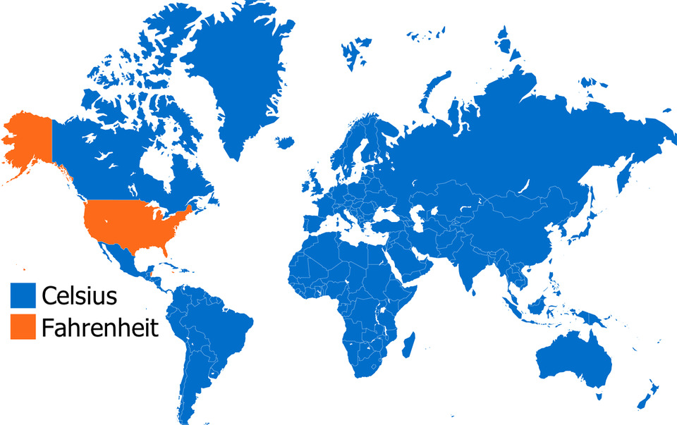
The mapmaker forgot Belize, Palau, the Bahamas and the Cayman Islands which all use Fahrenheit. As for "precision" all that is meant is the smaller difference between individual degrees but most humans can't perceive that small a difference, especially with wind chill, so the point is moot. And, btw- when Fahrenheit invented his thermometer he was trying to compute a scale for measuring body temperature so he chose 100º but his thermometer was off so it when more accurate thermometers came along the 'normal' body temperature had to be back-scaled to 98.6ºF.
Load More Replies...The bottom ones don’t even get a chance because they start off too far down and the list is overwhelmingly long. Just sayin. I know it gets condensed later but the bottom ones don’t get a chance to make the top 40, nobody sees them to upvote them.
My coin dish is a cast aluminum casserole dish in the shape of the continental US. It's weird because compared to most casserole dishes it's tiny, only 12 inches/30.5cm. I can understand wanting to make small baked dishes but why would you want one with that shape? My best guess is for loners who want to celebrate the Fourth of July by themselves. 20210221_1...19875b.jpg 
I loved this post! Went through every map. It inspired me to google all sorts of new things!
Fascinating maps. 🤩 There should be like a museum if it doesn’t exist all on maps! 🗺
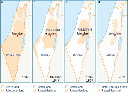
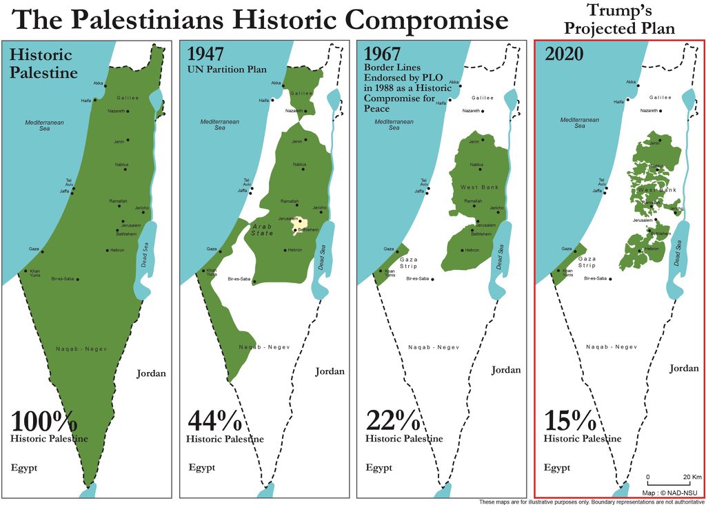
Can they show a map of PALESTINE and how much of the Israelies have taken by force?
That would be all of it... One of tbe few times in history a country has actually seized an ally's territory after a war.
Load More Replies...Glad you love it, Aragorn! Do you by any chance have any great maps of Middle Earth to share with us? :)
Load More Replies...I was on this post for almost an hour! I really enjoyed it.
The mapmaker forgot Belize, Palau, the Bahamas and the Cayman Islands which all use Fahrenheit. As for "precision" all that is meant is the smaller difference between individual degrees but most humans can't perceive that small a difference, especially with wind chill, so the point is moot. And, btw- when Fahrenheit invented his thermometer he was trying to compute a scale for measuring body temperature so he chose 100º but his thermometer was off so it when more accurate thermometers came along the 'normal' body temperature had to be back-scaled to 98.6ºF.
Load More Replies...The bottom ones don’t even get a chance because they start off too far down and the list is overwhelmingly long. Just sayin. I know it gets condensed later but the bottom ones don’t get a chance to make the top 40, nobody sees them to upvote them.
My coin dish is a cast aluminum casserole dish in the shape of the continental US. It's weird because compared to most casserole dishes it's tiny, only 12 inches/30.5cm. I can understand wanting to make small baked dishes but why would you want one with that shape? My best guess is for loners who want to celebrate the Fourth of July by themselves. 20210221_1...19875b.jpg
I loved this post! Went through every map. It inspired me to google all sorts of new things!
Fascinating maps. 🤩 There should be like a museum if it doesn’t exist all on maps! 🗺
Can they show a map of PALESTINE and how much of the Israelies have taken by force?
That would be all of it... One of tbe few times in history a country has actually seized an ally's territory after a war.
Load More Replies...


 No fees, cancel anytime


")


, The African Union Is Leading An Initiative To Plant The Great Green Wall, A 7,775 Km (4,830 Mi) Belt Of Trees Crossing The Entire Breadth Of North Africa")


")


")


")
")
")


")


")
")

. Officials Blame Unvaccinated Animals From North Korea Crossing Into The South Through The Porous Dmz")
 - Would Be Interesting To See How Different This Is In 10 Years Time")


")


")


")
")


![Europe (Detailed) - Ad 1337 - [6637x4983] [oc]](https://static.boredpanda.com/blog/wp-content/uploads/2021/02/602d118566f68_vlfxej9qb1g61__700.jpg "Europe (Detailed) - Ad 1337 - [6637x4983] [oc]")


")


")


![Exaggerated Elevation Map Of California [oc]](https://static.boredpanda.com/blog/wp-content/uploads/2020/12/5fe34ee73e89b_jijfes35zmy51__700.jpg "Exaggerated Elevation Map Of California [oc]")


![Average Elevation Above Sea Level Of European Countries [oc]](https://static.boredpanda.com/blog/wp-content/uploads/2021/02/602d0ec407adc_th4sqxf1teh61-png__700.jpg "Average Elevation Above Sea Level Of European Countries [oc]")

 Make A Topographic Pie Of The United States")


![Urban Megaregions Of The United States [oc]](https://static.boredpanda.com/blog/wp-content/uploads/2021/02/601d61be93677_i8ltr3zlxoe61-png__700.jpg "Urban Megaregions Of The United States [oc]")


![Europe (Detailed) - Ad 1066 - [6637x4983] [oc]](https://static.boredpanda.com/blog/wp-content/uploads/2020/12/5fe350dd2624e_8nj8ke2sqr061__700.jpg "Europe (Detailed) - Ad 1066 - [6637x4983] [oc]")


")


 And Last Night's Democratic Victory")


")
")
")