Get Premium
Dark mode theme is available exclusively for premium users. Learn more about the benefits of subscribing.
No fees, cancel anytime.

 Dark Mode Ad-Free Browsing Unlimited Content
 Ad-Free Browsing Unlimited Content Dark Mode
Join 1.2 million Panda readers who get the best art, memes, and fun stories every week!
Google Maps is one of those apps that many of us rely on daily (myself included). Whether it’s finding the fastest route, checking traffic, or scoping out the best-rated spots in town, it’s an essential tool.
But besides its usual functions, Google Maps has plenty of surprises if you know where to look. These people did just that—scanning satellite images and street views—and ended up stumbling upon things they never expected. From curious to downright bizarre, here are some of the strangest discoveries they made.
Scroll down to check them out, upvote your favorites, and maybe try your hand at it yourself. You never know what you might find!
This post may include affiliate links.
Playing around with the Google Street View car can be fun, but as these mechanics from Edinburgh discovered, sometimes having too much fun can have consequences. The two goofs forgot about the pranks until the photos were uploaded to Google months later and a concerned citizen called the police. The images depict a man assailing the other.
Luckily, one of the cops who "solved" the case had a friend who had his car serviced at the mechanic's shop where this took place. Dan Thompson, the shop's manager, told authorities: "It was in the spur of the moment [...] It seemed like the obvious thing to do so I threw myself on the ground and Gary grabbed a pick-axe handle from the garage."
If Google Maps suddenly vanished, we'd all be in trouble. It’s hard to even wrap your head around its scale when you look at the numbers. With over 2 billion monthly users, it’s the most popular navigation tool in the world. And in 2024 alone, it provided directions covering 1 trillion kilometers, which, according to Google, is like Earth orbiting the sun more than a thousand times.
But keeping a map this massive up to date is no small task. Google is constantly refining its data, making 100 million updates to the map every single day. That’s over 4 million updates per hour! And no wonder so many people rely on it to find their favorite spots. With 250 million businesses and places mapped out, getting where you need to go is extremely convenient.
If you're going to get caught lying to your spouse, you should try to make it count. Not like Donald Ryding, who was caught smoking in his driveway by Google Street View long after he told his wife that he'd kicked the habit. The car captured an image of Ryding trying to be furtive outside of his Merseyside home in England.
Mrs. Ryding said, "I couldn't believe it - there was no denying it now we'd seen him smoking. When Street View first launched, they didn't blur out faces, but there was no need to with him - he was covered by a cloud of smoke anyway." Burn.
Of course, Google Maps isn’t just about navigation. One of its coolest features is the ability to explore the world through satellite images and Street View. I use Street View all the time—to get a sense of a new place, check for parking (pro tip!), or just wander through different cities from my couch. It’s an amazing way to glimpse everyday life in countries all over the world.
Stan Herd lives nearby and he does amazing work similar to this. He's done big ads and was even in an oreo Comercial for his field art.
This image was captured in South Africa in 2010. While the man depicted in the image capture looks like an escapee from the United States, many pointed out he could be a municipal worker. In South Africa, some municipal workers wear orange as part of their uniform.
It's unclear where the man is running from or what he's running towards.
But have you ever wondered how Street View actually works? How does Google capture all those visuals, constantly update them, and upload them into a single app? And why go through all the trouble?
As Harold Stark explains in a 2017 Forbes article, back in 1998, when Google founders Sergey Brin and Larry Page started the company, they had a vision to “organize the world’s information and make it universally accessible and useful.” Google Maps is a huge part of that mission. By collecting an enormous amount of geospatial data and making it available in a mobile app, Google is essentially creating an interactive digital world.
After a teen in Groningen, Holland had his bike taken, he couldn't get the police to do anything about it. But six months later he found photo evidence using Google Street View. Cameras captured an image of the alleged culprits trailing behind the victim prior to taking the bike.
The 14-year-old used the image to help authorities apprehend two suspects.
Heard of this from a guy who served on Palau. He only knew it was near a shooting range the US military uses. With the help of google earth I found the possible location and went there during my visit to Palau a few years back.
Paulette Landrieux disappeared on November 2, 2020 without leaving a trail. At the time, the police spread a search message for the 'potentially confused woman', but even after a large -scale search she was not found.
The public prosecutor recently wanted to close the file unsolved after two years. But a person who made a final attempt caused a breakthrough: the man searched for the images of her house on Google Street View. There, as a miracle, you could see how the woman crossed the street to her neighbor's house.
The police then searched the garden of that man and found the corpse of Landrieux on the bottom of a hill, in the direction of the Meuse (Maas) river. The woman probably fell, but an autopsy must give a definitive answer.
Personally, as a researcher, I would study Google Maps the first day in such a case, but maybe it was not yet on Street View at the time.
To bring that world to life, Street View launched in 2007, letting users see real images of locations rather than just a flat map. But Google doesn’t do it all alone. For the base maps, they pull data from organizations like the U.S. Geological Survey, the Forest Service, and city councils, stitching together everything from massive highways to tiny backroads.
The convicted murderer, considered one of Italy's most wanted criminals, had been working as a chef under a different name in the town of Galapagar (near Madrid in Spain). Google Maps imagery showed a man who looked suspiciously like Gammino chatting outside a fruit and veg shop, and it was confirmed to be him by police later.
But how did they found the image? A face recognition program roaming the internet 24/7?
The story of the shipwreck on North Sentinel Island revolves around the MV Primrose, a cargo ship that ran aground near the island in 1981. The crew initially believed it was a routine stranding, but they soon realized the danger when the indigenous Sentinelese, a fiercely isolated tribe, began appearing on the beach armed with bows and arrows. The crew was stranded on the ship for several days, defending themselves with makeshift weapons and calling for help. Eventually, they were rescued by helicopter, narrowly avoiding contact with the Sentinelese, who remain one of the most isolated groups in the world.
Then, of course, there’s the Street View imagery, the part we love most. To capture those shots, Google sends out cars fitted with special 360-degree cameras, driving through streets, neighborhoods, and even quiet residential areas. You’ve probably seen one of these Street View cars yourself! Some lucky people even spot them in time to strike a pose—or, in the case of a group of kids in Syracuse, chase it down the street, securing their place in Google Maps history.
In 2015, a car that had both been missing since 2006 was found while employees at a Michigan mortuary home were decorating their building for Christmas. While looking in a nearby pond, they saw what looked like the roof of a car, promptly solving a nine-year-old missing person case. It turns out that the car had been visible on Google Street View this whole time.
Authorities did not suspect foul play, as it appears 72-year-old Davie Lee Niles may have driven into the body of water by accident.
it appears to be the "Redlands R". Put there by university student in 1913.
But cars aren’t always enough. To capture hard-to-reach places, Google also uses boats, snowmobiles, motorcycles, and even backpacks equipped with cameras for areas where vehicles can’t go, like the ancient ruins of Machu Picchu.
On a corner of Sagrada Família, in BH, there was a man who would sit next to a lamppost all day long. He had been spotted by the google maps car since 2015 in the same place. Recently, he disappeared. I was worried and went to find out what had happened
So, if you ever spot a Google Street View camera in the wild, why not give it a wave? Pull a funny pose! Who knows, you might end up immortalized in Google Maps, with a great story for your next team-building event or a killer “Two Truths and a Lie” icebreaker.
People were understandably freaked out when, in 2013, a pentagram appeared to be carved into the ground in a deserted part of Kazakhstan. Thanks to Google, the image came to public attention. No sign of life appears to be even close to the creepy symbol. In fact, Lisakovsk is the closest city to this patch of land, and it's about 12 miles away.
Before conspiracy theories could spin out of control, archaeologist Emma Usmanova told LiveScience: "It is the outline of a park made in the form of a star." Still, some don't believe Usmanova and think it could be linked to a more sinister, darker secret.
In the Greek city, those with pools are supposed to pay a special tax for them. There were 324 pool declared in Athens' suburbs — but after looking at Google Maps, authorities found out there were actually 16,974 pools in the area.
And since Google is capturing everything, everywhere, you can bet there are some weird, funny, or downright eerie things hidden across the app. If you’re ever bored or feeling a little adventurous, maybe take some time to hunt for them. Who knows what you’ll find?
I pulled up Google Maps just to see the taxiway configuration and the plane isn't there. It sure looks like the same general image as in OP's post, it even has the black rectangle next to where the plane is/was. It's entirely possible Google edited the image because someone reported it due to this post, but all I can say is the wingless plane isn't there now!
The fee for legal dumping would have been just $18. Police spotted the illicit dumping via Google Maps.
Atomic testing site..Nevada test range
This B-2 at Whitman AFB seems to be shown disabled after sliding off the runway. You can see the plane leaning on its left wing and emergency personnel around.
There seems to be some sort of small structure in the middle of each of those six pointed areas.
It’s just a chunk of ice that has shifted, no secret criminal mastermind’s bolt hole
A man told authorities he'd sold his home for €280,000, but the taxmen of Italy thought that didn't sound quite right. So, they cross-referenced an image of the property's distinctive pool to find the building — its location and size made them sure the declared sale price was wrong. Turns out he'd lied to the tune of seven million euro.
Of all the things I was expecting to see while looking at area 51 on Google maps the last thing I was expecting was a baseball field.
I wonder if it's like terrestrials vs extraterrestrials?
Sandy Island was first noted on nautical charts in 1876. Since it had a designated location, Google Earth tried to account for it in imagery, but couldn't do so. Finally, in 2012, a group of Australian scientists went to the region to discover that it didn't exist or no longer exists. They effectively "undiscovered" the island.
A Canberra. (loved modelling as a kid) 450px-Canb...e7c012.jpg 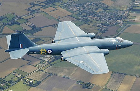
WAIS (Western Antarctic Ice Shelf) divide camp, nice find! I flew a twin otter on skis out of there a few years ago, recognized the ski way orientation to the camp and confirmed with coordinates. Here’s some images of the camp from the ground! For those wondering it’s a scientific camp open seasonally. When I was there it was used for researches to access “nearby” areas of interest of the Thwaites glacier, nicknamed the Doomsday glacier. There was a joint effort from USAP (United States Antarctic program) and BAS (British Antarctic Survey).
In October 1949, a Douglas C-47 Skytrain (tail number 316062) crash-landed near the station. No one was killed, but three on board were injured. The wreckage has been preserved by the cold weather and dry conditions.
Here I am, just cruising around google maps, when this...Thing (I guess?) catches my attention. The little bugger is just sneaking across a trail on a lonely mountain in the middle of the Canadian Rockies and I haven’t the foggiest what it is. Anyone else got a clue, ‘cause I sure as hell don’t
Yes to all the obstacles you mentioned.
Excluding the obvious obstacles of drilling in the middle of a vast desert, this region of Saudi has hydrocarbon reservoirs deeper than other regions.
Hydrocarbon wells in eastern Saudi are typically around 12,000 ft deep, while in the Rubi Al Khali desert the same reservoir would be around 18,000 ft deep. This is because the geological beds are dipping southeast. And this particular desert was a basin, so more sediments were deposited there.
Thus drill time is higher, and so costs are higher to drill there.
honestly I'm not really trying to conspire here all too much, I don't think that there's some extremely secret and malicious reason as to why they pasted planes around, but I know for a fact that it isn't a composite image, and I'm curious as to why they'd paste random planes around.

This is fun and cool. No Karens or Kardashians, no bridezillas, no office dramas. Just quirky weirdness and mystery. Love it. Thank you.
There are a lot of digitally altered photos here, but most were very interesting. Thanks.
This is fun and cool. No Karens or Kardashians, no bridezillas, no office dramas. Just quirky weirdness and mystery. Love it. Thank you.
There are a lot of digitally altered photos here, but most were very interesting. Thanks.


![Dad Of Two Asks, “Am I The [Jerk] For Leaving My Date At The Bar After She Insulted My Kids?”](https://www.boredpanda.com/blog/wp-content/uploads/2025/03/bar-kids-date_wide-Cover-67d277766e3ca.jpg)


 No fees, cancel anytime


")
")


")
")