ADVERTISEMENT

Depending on how old you are, you might remember having to pull out a paper map to find your way around a place. Back then, we didn’t have Siri or GPS. We were forced to put on our thinking caps and navigate the world in a slightly more complex way. Or risk getting completely lost. In today’s digital world, more than a billion people use Google Maps every month, but that doesn’t mean physical maps are a thing of the past.

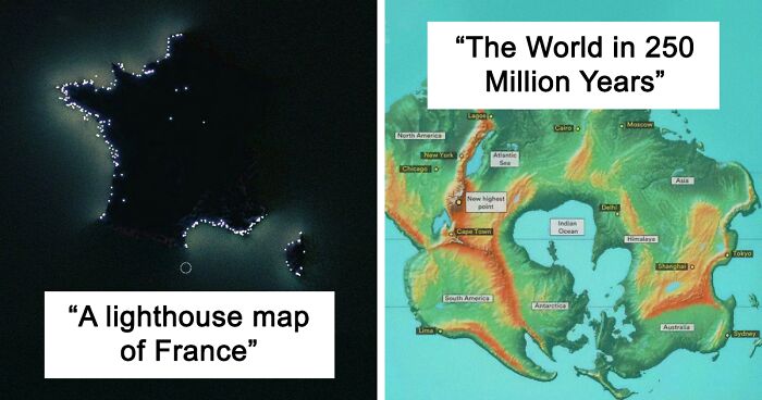
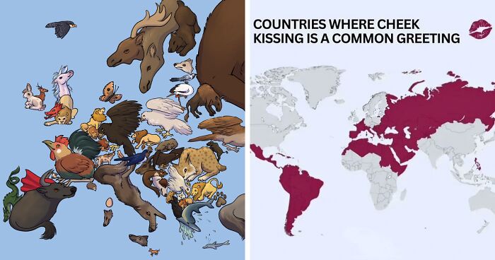
Maps aren’t only used for navigation after all, as this online group proves. It has more than 5.3 million members sharing fascinating maps detailing everything under the sun. From the most overworked countries in the world, to a visual representation of all the lighthouses in France, and even places where cheek-kissing is a common greeting.

We've picked the most intriguing posts from the page, to take you on a journey fit for the most curious of cartophiles. And on the subject of cartophiles, Bored Panda was lucky enough to chat to Ian Wright. He's a map guru and founder of Brilliant Maps, a popular cartography site. You'll find that interview between the images. And as a bonus, we've also included the fascinating story about a fake town that once appeared on a map, suddenly became real, then vanished again.

#1

The Alps, Hand-Drawn By Myself In Tolkien's Style, Please Suggest Any Improvements!

Detailed artistic map of the Alps, featuring intricate mountain illustrations across Europe.

NACHODYNAMYTE Report

Add photo comments
POST
BoredLittleLeafSheep
Community Member
2 weeks ago DotsCreated by potrace 1.15, written by Peter Selinger 2001-2017

Very cool! Had to click into Reddit to get a higher definition look and it is beautifully done. 👏👏👏

View more commentsArrow down menu

Ian Wright is a little bit obsessed with maps. But not the geographical kind. The cartophile and founder of Brilliant Maps tells Bored Panda he’s been interested more in the political, historical and economic sides of maps for as long as he can remember.

“My adult interest was really rekindled when I decided to walk London's Tube map, above ground of course. I found it was a really unique way to better get to know the city. And I also started looking more into what makes the Tube map unique,” he revealed.

Wright says this sparked an idea to start sharing maps he’d found on Twitter, the former bluebird app now known as “X”. Today, his account has more than 129,000 followers and over 16,000 posts. He’s branched out and built a successful business around his passion for maps.

“I initially started sharing maps on Twitter as a way to learn about the platform. At the start it was just fun sharing cool maps I'd seen,” he said during our interview. Wright tells us that after a few posts went viral, he realized that the platform wasn't the best place to include more data or nuance about the posts.

ADVERTISEMENT

“So I started the Brilliant Maps website as a place to better explain the maps and put them into a wider context,” he said. And that led to him releasing the Brilliant Maps book in 2019.

RELATED:
    #2

    Roads Of The Roman Empire

    Map of Roman Empire circa 200 AD, illustrating ancient roads not commonly seen in geography textbooks.

    T33FMEISTER Report

    Wright says besides the obvious getting us from point A to B, maps are a really useful tool to help quickly explain the world in ways that other forms of visualizations lack. “Unlike charts, graphs, or tables, maps inherently connect data to a place,” he explained. “This allows you to quickly see the difference between places today or the same place over time.”

    Wright adds that maps are a great tool for visualizing the world and a great tool for learning about the world. “My kids have both learned about maps at school as a way to better understand the differences between our neighbourhood, city, country and world,” he revealed.

    ADVERTISEMENT

    While some believe the digital age might lead to the death of traditional maps, Wright disagrees. “In terms of navigation it's tough to beat Google Maps,” he told us. “However, there's nothing like holding a paper map in your hand. I'm especially fond of historical maps. I recently purchased an original Booth Poverty Map of London and a 16th century map of Brugge, where I lived for a year with my wife.”

    Wright says he’s also a big fan of atlases “as you often spot something you never knew you didn't know (unknown unknowns).”

    So where does Wright see the future of maps heading? "I think the sort of maps I publish on Brilliant Maps aren't going away anytime soon, although if AI gets a bit better it may be the one making them!" he told Bored Panda.

    ADVERTISEMENT

    "In the real world, I think it's likely we'll likely get some sort of Augmented Reality, where you can ask an AI agent about what you're seeing in real time, better optimize your route based on certain criteria, etc."
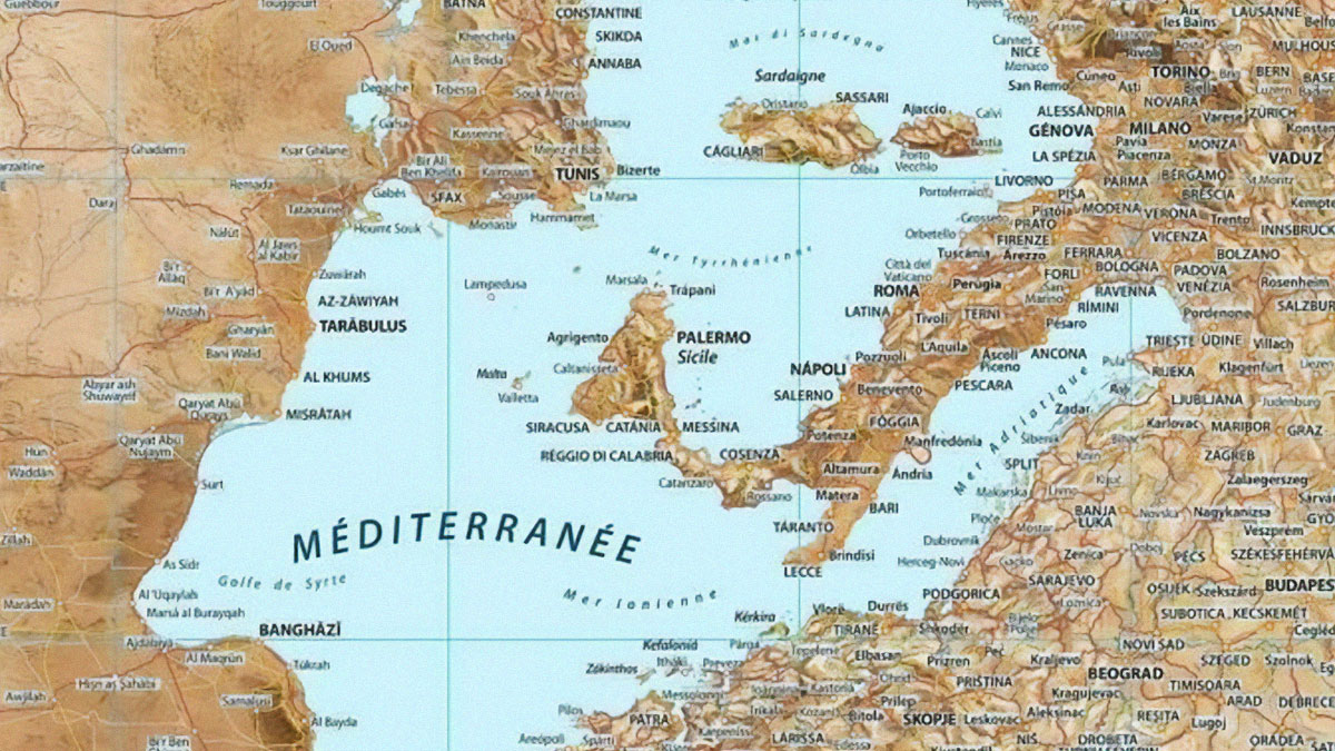
    #4

    In Maori The Official Name For France Is Wiwi (Oui Oui)

    Unique map illustration showing Europe with Māori place names, highlighting areas like Paris and Rome.

    shinjirarehen Report

    #5

    A Lighthouse Map Of France

    Map of France illuminated by lighthouses, showcasing an unusual perspective from geography textbooks.

    AdAbject6946 Report

    #6

    Map Of Africa On The Year 1880 Ad, Before The European "Scramble For Africa"

    Colorful 1880 map of Africa, displaying tribal and state borders before the European colonization.

    Individual-Sun-9426 Report

    Maps are generally seen as pretty reliable. But you might be surprised to know that cartographers (the people who make maps) sometimes insert fake towns and streets onto them. They aren’t doing this to confuse travelers but rather to catch anyone who tries to forge the map, or infringe on copyright.

    ADVERTISEMENT

    The fake places are known as “paper towns” and “trap-streets”. And in a super bizarre turn of events, one of the phantom towns became real for a short while, before swiftly disappearing again.

    #7

    Are You Certain That God Exists?

    Map showing percentage of population absolutely certain God exists in USA and Europe, highlighting geographic differences.

    FLVCKO_JODYE Report

    #8

    What Antarctica Looks Like Without Ice

    Unusual geography map depicting an abstract landmass with varied terrain against a deep blue ocean background.

    vladgrinch Report

    Add photo comments
    POST
    Marie Clear
    Community Member
    2 weeks ago DotsCreated by potrace 1.15, written by Peter Selinger 2001-2017

    Oh, I think we'll be brining this map out as "official" very soon!

    View more commentsArrow down menu
    ADVERTISEMENT
    #9

    Map Of Europe Made Up Of Its National Animals

    Illustrated animals forming a map, creatively replacing traditional geography textbook visuals.

    Ibis_Wolfie Report

    Add photo comments
    POST
    JinxBox
    Community Member
    2 weeks ago DotsCreated by potrace 1.15, written by Peter Selinger 2001-2017

    Tiny finnish bear never felt comfortable next to huge bear next door

    View more commentsArrow down menu

    In the 1930s, Otto G. Lindberg and Ernest Alpers from General Drafting Co. were making a road map of New York state. They decided to make up a fictitious hamlet called “Agloe”, and marked it on a dirt road, somewhere between Rockland and Beaverkill. The duo came up with the name by combining letters of their own names. The map was printed and that was that… or not.

    ADVERTISEMENT

    As it turns out, a well-known map company called Rand McNally created their own New York state map a few years later. They seemingly fell straight into the trap, placing "Agloe" on the same spot as General Drafting Co. had.

    Naturally, when Lindberg got wind of this, he mapped out his revenge and took the matter to court, but his rivals warned that he wouldn't win the case. The defendants claimed that “Agloe” did in fact exist. And they had grounds to prove it.

    #10

    Has Russia Ever Been At War With You?

    Map showing European countries at war with Russia, marked as "Yes" or "No" in green and red colors.

    Master1_4Disaster Report

    Add photo comments
    POST
    Ivan Stojnov
    Community Member
    2 weeks ago DotsCreated by potrace 1.15, written by Peter Selinger 2001-2017

    Serbia here. Never been in war with Moscow but in the Balcan wars we were betrayed by our rusian ally and after WWII Stalin tried very hard to kill Josip Broz Tito (president of Yugoslavia) and take over the country but never succeeded. So, almost.

    View more commentsArrow down menu
    #12

    Kiribati: The Only Country Spanning All Four Hemispheres

    Map showing Kiribati and Ecuador near the 180° meridian, highlighting geography not in typical textbooks.

    ChemistStrong5527 Report

    ADVERTISEMENT

    McNally pointed out that Agloe had a general store, and if Lindberg and his team visited the area, they'd find the shop at the intersection marked on the map. They weren't wrong. Strangely, a shopkeeper had spotted Agloe on a map, and decided to start a business there. This is despite a lack of any surrounding houses or signs of life. Nevertheless, that shop provided enough proof for General Drafting to avoid being sued for copyright infringement.

    #13

    So This Is What They Meant By The Dwarf Planet

    Map comparing Pluto and Australia in size; a unique geography perspective.

    the_pacman_88 Report

    Add photo comments
    POST
    Tucker Cahooter
    Community Member
    2 weeks ago DotsCreated by potrace 1.15, written by Peter Selinger 2001-2017

    That's going to be nightmare for the Indian Pacific train to navigate around

    View more commentsArrow down menu
    #14

    USA Abortions Ban With And Without Exceptions For R**e

    Map showing U.S. states with varying abortion laws, including bans and exceptions, highlighting geographic differences.

    sycamoreshadows Report

    Add photo comments
    POST
    chi-wei shen
    Community Member
    2 weeks ago DotsCreated by potrace 1.15, written by Peter Selinger 2001-2017

    Did BP really have to censor r a p e? In the context of this map, an explanation of exceptions is necessary.

    View more commentsArrow down menu
    #15

    Ship-Log Entries 1740-1855

    Ship's log entries from 1740-1855, showing global trade routes from England, Netherlands, Spain, and France on world maps.

    Place_ad_here Report

    Agloe's general store didn't last long. We'd hazard a guess it had to do with a lack of demand. But the whole ordeal certainly put the town on the map, so to speak. Author John Green even mentioned it in his novel Paper Towns. "When its protagonist Margo disappears, she leaves oblique clues as to her whereabouts. The trail leads to somewhere and nowhere – Agloe," reported the Guardian.

    ADVERTISEMENT
    #16

    Countries Banned From The Olympics

    Map showing countries banned from the Olympics for war aggression and political stances, 1920-2024.

    PSIDAC Report

    Add photo comments
    POST
    Karina
    Community Member
    2 weeks ago DotsCreated by potrace 1.15, written by Peter Selinger 2001-2017

    "russia is banned, but they sure are gaming. Given a different name to compete under, so noone will think about all the drugging and waring

    View more commentsArrow down menu
    #17

    British English vs. American English: What’s Taught In Schools?

    Map showing countries using American English in red and British English in blue, highlighting language distribution globally.

    vladgrinch Report

    #18

    The Hippie Trail, Where Western Hippies Travelled Throughout The 60s And 70s Usually To Consume D**gs And Spiritual Awakening(Oc)

    Map of the Hippie Trail showing routes from Europe to Asia, highlighting major cities not in your geography textbooks.

    Wally_Squash Report

    Add photo comments
    POST
    JinxBox
    Community Member
    2 weeks ago (edited) DotsCreated by potrace 1.15, written by Peter Selinger 2001-2017

    I was born on the hippie trail ✌🏼 "Hippie parents" has always been an explanation enough when people ask how on earth did I end up being born in Kathmandu

    View more commentsArrow down menu

    Some maps still feature the little hamlet of "Agloe." It was even visible on Google Maps, until it was removed in 2014. Despite its non-existence, people flock to visit "Agloe", intrigued by the back story of this mythical "paper town". And maybe today, a general shop would be useful commodity on that deserted dirt road after all.

    #19

    All Countries That Legalized Same-Sex Marriage So Far

    Unique geography map showing countries in dark blue and light gray.

    Impressive_Produce3 Report

    ADVERTISEMENT
    #20

    Countries With Compulsory Voting

    Map showing global status of compulsory voting with color-coded legend for enforcement levels.

    Ok-Revolution-83 Report

    Add photo comments
    POST
    Judes
    Community Member
    2 weeks ago DotsCreated by potrace 1.15, written by Peter Selinger 2001-2017

    In Australia the fine for not voting is AU$20, so yes it's enforced but barely.

    View more commentsArrow down menu
    #21

    Every Dot Is A Football (Soccer) Pitch

    European map highlighting urban areas in red, displaying diverse geographical features.

    katxwoods Report

    "Agloe" wouldn't be the only phantom place to appear on Google Maps. In 2009, a place called Argleton attracted camera crews and made headlines. But when reporters visited the "village" near Ormskirk, Lancashire, all they found was... nothing much but a muddy field.

    #23

    Where Cheek Kissing Is A Common Greeting

    Map showing countries where cheek kissing is a common greeting, highlighting areas not typically in geography textbooks.

    rayg10 Report

    Add photo comments
    POST
    Tucker Cahooter
    Community Member
    2 weeks ago DotsCreated by potrace 1.15, written by Peter Selinger 2001-2017

    Well, at least they made an effort to include New Zealand in the map, pity it's adrift in the Southern Ocean

    View more commentsArrow down menu
    #24

    Countries ‘Colonized’ By Europe

    Map showing countries colonized by Europe, partially controlled, and never colonized in different shades.

    Big_Abrocoma496 Report

    Add photo comments
    POST
    Russell Tilling
    Community Member
    2 weeks ago DotsCreated by potrace 1.15, written by Peter Selinger 2001-2017

    Since humans most likely originated in Africa, everywhere has been 'colonized' by humans migrating out of Africa. The UK has been colonized by Romans, Angles, Saxons, Vikings, etc.

    View more commentsArrow down menu

    "I grew up in the area and spotted on the map one day that it said 'Argleton'. But it's just a farmer's field close to the village hall and playing fields. I think a footpath goes across the field, but that's all," said Mike Nolan, the man who originally spotted the village on Google Maps. "The name 'Argleton' is similar to 'Aughton'. Maybe someone made a mistake when keying in the name?"

    ADVERTISEMENT

    Maybe. Or maybe Argleton, like Agloe, is simply a paper town in a digital world where people love a good mystery.

    #25

    None Of The Countries That Bordered Poland Before 1990 Exist Today

    Map comparison of Eastern Europe in 1989 and 2022, highlighting geography changes from the USSR era to present.

    The_Unknown_Soldier_ Report

    #26

    The World In 250 Mil. Years From Now

    Future map showing Earth's continents merging into Pangaea Proxima, highlighting cities and geographic features.

    Bobbergobbler Report

    Add photo comments
    POST
    Sue Denham
    Community Member
    2 weeks ago DotsCreated by potrace 1.15, written by Peter Selinger 2001-2017

    Is that New Zealand off on its own on the far right? Woohoo - we made it onto the map *and* managed to stay away from all the madness.

    View more commentsArrow down menu
    #27

    Is It Legal To Cook Lobsters?

    Map showing where cooking lobsters alive is legal or illegal in Europe, highlighting in green and red.

    No_Significance_8874 Report

    #28

    U.S. Counties With A Life Expectancy Above 80 Years

    Map showing U.S. counties with life expectancy over 80 years, highlighting areas not seen in standard geography textbooks.

    Nidzovantije Report

    Add photo comments
    POST
    Weasel Wise
    Community Member
    2 weeks ago DotsCreated by potrace 1.15, written by Peter Selinger 2001-2017

    A lot of the shading is in the northern states....probably cuz meat rots slower in the fridge. 🤣

    View more commentsArrow down menu
    #29

    Africa's Religious Divide

    Map illustrating religious divide in Africa, highlighting Muslim, Christian, and Hindu regions.

    Ta9eh10 Report

    Add photo comments
    POST
    UpupaEpops
    Community Member
    2 weeks ago DotsCreated by potrace 1.15, written by Peter Selinger 2001-2017

    I would be interested in where traditional faith is more prevalent

    View more commentsArrow down menu
    #30

    A World Map Found In The Lobby Of A Chinese Hotel

    Unusual world map with China at the center, highlighting geographic perspectives not seen in textbooks.

    Constant-Cress2906 Report

    Continue reading with Bored Panda Premium
    Unlimited content
    Ad-free browsing
    Dark mode
    ADVERTISEMENT
    #32

    Countries Without A Metro System In Europe

    Map highlighting European countries without a metro system in red.

    quindiassomigli Report

    #34

    Germany Economy Is The Same Size As The Highlighted Countries

    Map comparing Germany's economy size with neighboring countries' combined GDP in 2024.

    rayg10 Report

    Add photo comments
    POST
    Karina
    Community Member
    2 weeks ago DotsCreated by potrace 1.15, written by Peter Selinger 2001-2017

    did they include the norwegian oil fund here? Because this crashes a bit with what i have read. I know germany has money, but still.

    View more commentsArrow down menu
    #35

    Football Matches That Are Banned By Uefa & Fifa

    Map showing territorial disputes in Europe and Asia with colored sections indicating Spain, Armenia, Ukraine, and Kosovo regions.

    kakafonie Report

    Add photo comments
    POST
    Fat Harry (Oi / You)
    Community Member
    2 weeks ago DotsCreated by potrace 1.15, written by Peter Selinger 2001-2017

    I really feel that Spain and Gibraltar could probably just get on with it.

    #36

    Netherlands Over Time

    Comparison of maps showing the Netherlands in 1300 and today, highlighting geographical changes over time.

    AliceInBoredom Report

    Add photo comments
    POST
    Multa Nocte
    Community Member
    2 weeks ago DotsCreated by potrace 1.15, written by Peter Selinger 2001-2017

    It took Hans Brinker many years of leaving his thumb in that dike to produce what we now see. ;-)

    View more commentsArrow down menu
    #37

    Religion And Literacy Rate In Nigeria

    Maps of Nigeria showing religion distribution and literacy rates. Islam: 51.1%, Christianity: 46.9%. Literacy: 77.6%.

    ellatino230 Report

    Add photo comments
    POST
    TotallyNOTAFox
    Community Member
    2 weeks ago DotsCreated by potrace 1.15, written by Peter Selinger 2001-2017

    That is only logical given that the Islam in that part of Earth pretty much denies education to girls and women often enforced by massive violence

    View more commentsArrow down menu
    #38

    Most Common Birth Country For Foreign Residents In The Us (Excluding Mexico)

    Map showing the most common country of birth for foreign-born residents by U.S. state, excluding Mexico.

    anonymous Report

    ADVERTISEMENT
    #39

    Sweden When They Voted On To Change To Euro Currency. 💶 No Side Won With Only 55.91%, But The Biggest Populated Regions Voted Yes

    Map showing areas in Sweden with voting results, highlighting regions in red and green from geography textbooks.

    HejInternet Report

    Add photo comments
    POST
    WindySwede
    Community Member
    2 weeks ago DotsCreated by potrace 1.15, written by Peter Selinger 2001-2017

    Haparanda? Is that because of the close proximity to Finland? With border shopping?

    #40

    Mean Age Of Women At Birth Of First Child

    Map showing the mean age of women at birth of first child across Europe, highlighting variations in age data.

    theworldmaps Report

    Add photo comments
    POST
    Guess Undheit
    Community Member
    2 weeks ago DotsCreated by potrace 1.15, written by Peter Selinger 2001-2017

    Showing again a high correlation, this time between wealth and birth age.

    View more commentsArrow down menu
    #41

    Countries By English Proficiency

    World map showing countries by English proficiency levels, with color-coded categories from very high to very low.

    AdIcy4323 Report

    #42

    Politicians K**led In Mexico Since The Start Of 2024

    Map of Mexico showing places where 38 politicians were affected since 2024, marked with red location pins.

    Winter-Leadership986 Report

    #43

    All The Countries Mentioned In The Bible

    Map highlighting countries in the Middle East and North Africa, not typically shown in geography textbooks.

    Persistent_Bug_0101 Report

    Add photo comments
    POST
    Multa Nocte
    Community Member
    2 weeks ago DotsCreated by potrace 1.15, written by Peter Selinger 2001-2017

    So why don't the rest of us get a "Get out of jail free" card from Christianity?

    View more commentsArrow down menu
    #44

    Christianity In The Middle East

    Map showing percentage of Christians in Middle Eastern countries including Egypt, Saudi Arabia, Iran, and others.

    Individual-Sun-9426 Report

    Add photo comments
    POST
    #45

    The German Language Area Before And After The World Wars

    Map showing German language areas in 1910 and 2021, highlighting changes after the world wars.

    Homesanto Report

    Add photo comments
    POST
    Kenneth Barns
    Community Member
    2 weeks ago DotsCreated by potrace 1.15, written by Peter Selinger 2001-2017

    Today I learned ... that German is (or rather, that German dialects are) no longer the majority language in Lorraine and Alsace, having been displaced by standard French in the last generation or so.

    View more commentsArrow down menu
    #46

    5G Availability By Country

    Global map showing new 5G locations as of 2023, highlighting areas not typically found in geography textbooks.

    throwawayyy19283747 Report

    Add photo comments
    POST
    ƒιѕн
    Community Member
    2 weeks ago DotsCreated by potrace 1.15, written by Peter Selinger 2001-2017

    So says my cell phone provider but of course they lied to me.

    View more commentsArrow down menu
    ADVERTISEMENT
    See Also on Bored Panda
    #47

    Piracy In 21st Century

    Map showing piracy risk in the 21st century, highlighting high-risk areas like Gulf of Guinea and Horn of Africa.

    andromeda324 Report

    Add photo comments
    POST
    ƒιѕн
    Community Member
    2 weeks ago

    I take it were not talking about pirating software, cause if that was the case this map is oh so wrong.

    View more commentsArrow down menu
    #48

    The Black Population In The Us In 1900 vs. 2020

    Geography maps showing U.S. population distribution in 1900 and 2020, with varying green shades indicating density percentages.

    IllustriousDudeIDK Report

    Add photo comments
    POST
    Corwin 02
    Community Member
    2 weeks ago DotsCreated by potrace 1.15, written by Peter Selinger 2001-2017

    looks like they spread out some more from the south to the west and north , what I find weird is only a 0.8% increase in total black population

    View more commentsArrow down menu
    #49

    Population Growth In Western European Countries Between 1950 & 2020

    Maps showing European population changes from 1950 to 2020, highlighting significant demographic shifts.

    reddit.com Report

    #51

    Us States With A Ban On Construction Of Nuclear Power Plants

    Map showing U.S. states with statewide moratoriums highlighted in blue.

    IsleFoxale Report

    #52

    Countries Not Self Identified As Democratic

    Map showing countries not self-identified as democratic, including Afghanistan, Brunei, and Saudi Arabia.

    Individual-Sun-9426 Report

    Add photo comments
    POST
    General Anaesthesia
    Community Member
    2 weeks ago DotsCreated by potrace 1.15, written by Peter Selinger 2001-2017

    Like a politician self-identifying as "I am not a crook", self-identifying as democratic can be misleading.

    View more commentsArrow down menu
    #53

    Christianity In The Us By County

    Map showing Christianity distribution by county in the US, highlighting Protestantism, Catholicism, and Mormonism.

    zevalways Report

    ADVERTISEMENT
    See Also on Bored Panda
    #54

    Global Cancer Rates In People Under 50

    Global cancer rates map for people under 50, showing cases per 100,000 worldwide using a color gradient.

    Acceptable_Tennis_14 Report

    #55

    United States Counties Where Selling Of Alcohol Is Completely Prohibited

    Map of the United States highlighting counties where alcohol sales are completely prohibited.

    dphayteeyl Report

    #56

    The Percentage Of Homes With Air Conditioning Across The World

    World map showing air conditioning usage percentages by country, highlighting USA, Japan, and Saudi Arabia.

    Individual-Sun-9426 Report

    Add photo comments
    POST
    Corvus
    Community Member
    2 weeks ago DotsCreated by potrace 1.15, written by Peter Selinger 2001-2017

    Air conditioning has become pretty common in Europe, actually.

    View more commentsArrow down menu
    #57

    Five Areas Of Brazil With The Same Population

    Map of Brazil showing five areas with equal population distribution.

    eortizospina Report

    Add photo comments
    POST
    MC C
    Community Member
    2 weeks ago DotsCreated by potrace 1.15, written by Peter Selinger 2001-2017

    why did this map make two different sets of areas the same color? Is this map creator only aware of 3 colors?

    #58

    The Word "Soda" Sweeps Across The Us

    Map showing US regional terms for carbonated drinks in 1947 and 2024: "Pop," "Soda," "Coke."

    Cow_Fam Report

    Add photo comments
    POST
    Ray Ceeya (RayCeeYa)
    Community Member
    2 weeks ago DotsCreated by potrace 1.15, written by Peter Selinger 2001-2017

    I can't wait until Fox News sees this map. They're going to start calling "Soda" creeping socialism/communism and it's all a plot to make your kids trans. Or something else super weird.

    View more commentsArrow down menu
    #59

    Second Biggest Religion In European Countries

    Map of Europe showing predominant religions by country not typically seen in geography textbooks.

    Few_Introduction9919 Report

    Add photo comments
    POST
    Bernd Herbert
    Community Member
    2 weeks ago DotsCreated by potrace 1.15, written by Peter Selinger 2001-2017

    German here: "Second biggest" is quite relative. Nowadays the majority of people is not religious at all. So your baseline is much much smaller to begin with. And second biggest in Germany means around 6% of the population.

    View more commentsArrow down menu
    #60

    Countries Where Wikipedia Editors Have Been Prosecuted

    Map highlighting countries where Wikipedia editors have faced prosecution, showing areas in red.

    quindiassomigli Report

    ADVERTISEMENT
    See Also on Bored Panda
    #61

    Spread Of The Industrial Revolution

    Map showing the spread of the Industrial Revolution across Europe from the 1840s to 1880s.

    Galadriaume Report

    Add photo comments
    POST
    Ace
    Community Member
    2 weeks ago DotsCreated by potrace 1.15, written by Peter Selinger 2001-2017

    Weird that they've left off half of the UK, as if the spread only happened in a SE direction and the NW of Britain remained unaffected.

    View more commentsArrow down menu
    #62

    Countries Where Leaving Your Religion (Apostasy) Is Punished

    Map showcasing apostasy laws across different countries, highlighting regions with death penalty, prison, and other penalties.

    coronaredditor Report

    #63

    Israel Travel Advisory Map

    Travel advisory map of Europe with color-coded safety ratings: safe, potential threat, avoid, prohibited.

    AdIcy4323 Report

    #64

    17.11.2024 Russian Massive Missile Attack On Ukraine

    Geography map with colorful arrows showing air target movement across Ukraine during a missile-drone attack.

    Alikont Report

    Add photo comments
    POST
    Corvus
    Community Member
    2 weeks ago (edited) DotsCreated by potrace 1.15, written by Peter Selinger 2001-2017

    All this happens because we allow it to happen. In 2022, the rest of Europe should have immediately sent troops to Ukraine. Putin would have withdrawn immediately (he is a coward), and the whole war would have been avoided... alas, too late now.

    View more commentsArrow down menu
    #65

    Darkest Legal Front Side Window Tint By State

    Map showing the darkest legal front window tint percentages by U.S. state.

    YutongH Report

    Add photo comments
    POST
    Rocket Surgeon
    Community Member
    2 weeks ago (edited) DotsCreated by potrace 1.15, written by Peter Selinger 2001-2017

    Wait is the tinting of the states opposite to what the tinting of the windows is allowed? Michigan is listed as 0% but is totally black, implying their windows are the darkest.

    View more commentsArrow down menu
    #66

    Percent Of People Over 25 Who Have Completed High School In The United States

    Map showing high school completion rates for people over 25 across U.S. counties, highlighting geographical variations.

    Reecethehawk Report

    Add photo comments
    POST
    Multa Nocte
    Community Member
    2 weeks ago DotsCreated by potrace 1.15, written by Peter Selinger 2001-2017

    Wyoming is because they only have 12 people who actually live in the state. ;-)

    View more commentsArrow down menu
    #67

    Nearly 30% Of The World's Landmass Is Named After Italian People Or Cities

    World map highlighting Italy and regions named after Italian cities and people in various shades of green and red.

    EuropeanAustralian Report

    ADVERTISEMENT
    See Also on Bored Panda
    #69

    Fertility Rates Decreased Nationwide From 2005 To 2022

    Map of U.S. showing fertility rate changes by state from 2005 to 2022, highlighting a nationwide decrease.

    Ok_Somewhere9687 Report

    Add photo comments
    POST
    Karina
    Community Member
    2 weeks ago DotsCreated by potrace 1.15, written by Peter Selinger 2001-2017

    fertility rates or acsess to proper education and healtcare? Like birthcontroll

    View more commentsArrow down menu
    #70

    With Almost Every Vote Counted, Every State Shifted Toward The Republican Party

    Map of the United States showing margin changes from 2020 in various shades of pink and red.

    EverestMaher Report

    #71

    Countries In The "Western Sphere" According To Harvard's School Of International Relations Published 2017

    World map showing Western Core, Periphery, and Westernization regions, not in typical geography textbooks.

    Sad-Dragonfruit-489 Report

    Add photo comments
    POST
    #73

    The Ivy League Universities Of The USA

    Map showing Ivy League universities in the northeastern United States.

    dphayteeyl Report

    Add photo comments
    POST
    JessieJ&LilyLovebug
    Community Member
    2 weeks ago DotsCreated by potrace 1.15, written by Peter Selinger 2001-2017

    There was a study conducted a few years ago that found that the quality of education at an Ivy League school was not greater than that of other universities and colleges; the only greater benefit was in the connections made as a result.

    View more commentsArrow down menu
    #74

    Since 2022, The Tesla Model Y Has Been The Best Selling Car In California. While Nationally, Pickup Trucks Still Hold The Top 3 Spots (#1 Ford F-Series, #2 Silverado, And #3 Ram)

    Map showing the best-selling cars in each U.S. state for 2022, highlighting various popular models across the country.

    Solaris-Bloch Report

    Add photo comments
    POST
    Carl Roberts
    Community Member
    2 weeks ago DotsCreated by potrace 1.15, written by Peter Selinger 2001-2017

    I live in California. Tesla drivers have replaced BMW drivers as the most obnoxious d-bags on the highways

    View more commentsArrow down menu
    ADVERTISEMENT
    See Also on Bored Panda
    #75

    U.S. Counties Where The Non-Hispanic White Americans Is 90% Or Higher

    Map showing U.S. counties where non-Hispanic White population is 90% or higher, focusing on geography data.

    vividmaps Report

    Add photo comments
    POST
    Joemama
    Community Member
    2 weeks ago

    This comment has been deleted.

    View more commentsArrow down menu
    #76

    The Only Counties That Voted For The Winning Party Since The 2000 U.S. Presidential General Election, Blaine, Mt, And Essec, NY

    Map highlighting counties voting for the winning party since 2000.

    ViolentNun Report

    Add photo comments
    POST
    MC C
    Community Member
    2 weeks ago DotsCreated by potrace 1.15, written by Peter Selinger 2001-2017

    winning party for what? President, House Majority, Senate Majority? Also, this really doesn't make sense, in the US we are not a parliamentary system, so we don't vote for a party

    #77

    Percent Of Adults Getting Less Than 7 Hours Of Sleep Per Day

    Map of the United States showing obesity prevalence by county with color-coded percentages.

    doNOTbanthisaccont Report

    Add photo comments
    POST
    Fat Harry (Oi / You)
    Community Member
    2 weeks ago DotsCreated by potrace 1.15, written by Peter Selinger 2001-2017

    Add me to that. Animals, a full-time job, and a newborn baby in the house will do that to you.

    View more commentsArrow down menu
    #78

    Californias Presidential Results Map 2020 V 2024

    California maps showing district changes from 2020 to 2024, not found in standard geography textbooks.

    Puzzleheaded-Art-469 Report

    Add photo comments
    POST
    #79

    "First Wave" Of Rocket Alerts In Israel. Rockets Were Sent Directly From Iran

    Map with numerous red location markers in Israel, showing geography not typically seen in textbooks.

    Amirjun Report

    Add photo comments
    POST
    ADVERTISEMENT
    See Also on Bored Panda
    Ic_polls

    Poll Question

    Do you still use physical maps for navigation?

    Yes, often

    Sometimes, but rarely

    Never, only digital

    I prefer not to navigate